
-
Research Article
-
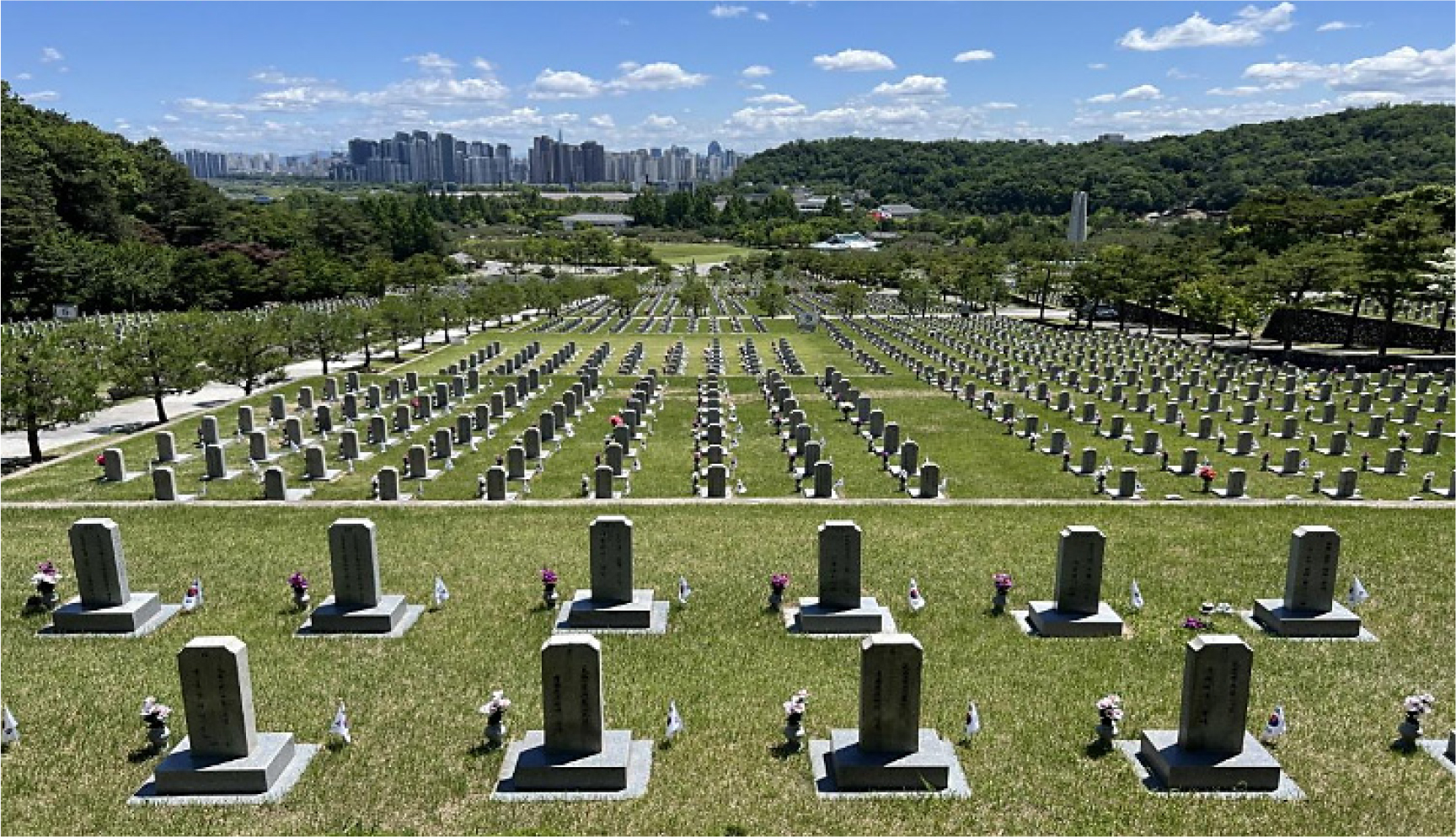
‘죽은 자들 앞에서 정치 지도자 되기’의 문화경관 - 한국 국립묘지 참배 의례 공간정치와 영토화된 정치적 리더십 -
The Cultural Landscape of Becoming a Political Leader before the Dead: The Spatial Politics of Commemorative Rituals at South Korea’s National Cemeteries and Territorialized Political Leadership
-
송원섭
Wonseob Song
- 본 논문은 한국 정치 엘리트의 국립묘지 참배를 애도의 표현이자 동시에 정치적 리더십이 생산되는 국가의례로 분석한다. 이를 위하여 본 논문은 2023년부터 2026년까지 국립서울현충원과 …
This paper analyzes the repeated visits of South Korean political elites to national cemeteries as state rituals through which political leadership is …
- 본 논문은 한국 정치 엘리트의 국립묘지 참배를 애도의 표현이자 동시에 정치적 리더십이 생산되는 국가의례로 분석한다. 이를 위하여 본 논문은 2023년부터 2026년까지 국립서울현충원과 국립대전현충원을 중심으로 공개된 대통령, 정당 지도부, 정부 고위직의 참배 장면을 핵심 사례군으로 설정하고, 국립5・18민주묘지 관련 보조 비교사례와 함께 정책브리핑・청와대 브리핑・현충원 포토자료, 언론 기사 및 사진, 현충원 조직・시설 자료를 교차 분석하였다. 분석 결과, 첫째, 국립묘지 참배는 새해 첫 일정, 취임 직후, 현충일과 같은 정치적 문턱에서 정치의 시간을 질서화한다. 둘째, 현충문-현충탑-분향-묵념-방명록으로 이어지는 의례적 동선은 정치인의 신체를 국가적으로 승인된 애도의 문법 속에 배치한다. 셋째, 공식 사진과 언론 사진, 그리고 그것에 결합된 서사는 죽은 자들을 엄숙한 배경으로 후퇴시키는 동시에 살아 있는 정치 지도자를 전경화한다. 또한, 서울현충원이 중앙정치의 국정 개시 무대로 기능한다면, 대전현충원은 분산된 국가기관과 지역정치가 애국적 정당성을 수행하는 보조 무대로 기능한다. 결론적으로 한국의 국립묘지는 애국적 기억의 저장소일 뿐만 아니라, 죽은 자들을 매개로 살아 있는 정치 권위를 반복적으로 승인하게 하는 상징적 인프라이다. 본 논문은 문화지리학의 관점에서 국가추모, 영토화, 의례화된 이동, 미디어화된 시각 위계, 정치적 리더십의 생산을 연결하는 분석 틀을 제시한다.
- COLLAPSE
This paper analyzes the repeated visits of South Korean political elites to national cemeteries as state rituals through which political leadership is produced as much as mourning is expressed. To do so, it constructs a core set of cases drawn from publicly circulated visits by presidents, party leaders, and senior state officials to the Seoul and Daejeon National Cemeteries between 2023 and 2026, while using supplementary comparative cases from the National May 18 Cemetery. Official photographs and policy briefings, media reports and press images, and institutional materials on the cemeteries’ organization and facilities are cross-read. The analysis shows, first, that cemetery visits order political time at threshold moments such as the first schedule of the year, the immediate aftermath of inauguration, and Memorial Day. Second, the ritual route from the memorial gate to the memorial tower, incense offering, silent bowing, and memorial-book writing places the politician’s body within a nationally sanctioned grammar of mourning. Third, official and press photographs, together with their captions, push the dead into a solemn background while foregrounding the living political leader. The Seoul National Cemetery thereby functions as a central stage for inaugurating national politics, whereas the Daejeon National Cemetery works more often as an auxiliary stage for the distributed performance of patriotic legitimacy by state agencies and regional political actors. In conclusion, South Korea’s national cemeteries are not merely repositories of patriotic memory but symbolic infrastructures through which living political authority is repeatedly authorized through the dead. From a cultural-geographical perspective, this paper links national mourning, territorialisation, ritualised movement, mediatized visual hierarchy, and the production of political leadership.
-
‘죽은 자들 앞에서 정치 지도자 되기’의 문화경관 - 한국 국립묘지 참배 의례 공간정치와 영토화된 정치적 리더십 -
-
Research Article
-
북한 토지황폐화의 지형적 분포 패턴 - 산지 중심 인식의 재검토 -
Topographic Patterns of Land Degradation in North Korea: Rethinking the Mountain-Centered Perspective
-
안유순
Yoosoon An
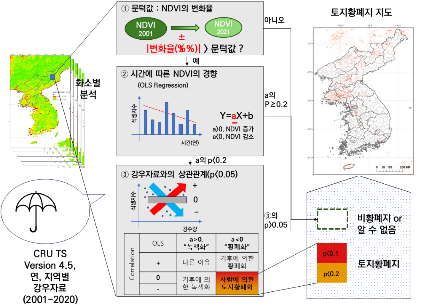
- 이 연구는 북한의 토지황폐지가 어떠한 지형적 조건에서 발생하는지를 규명하고, 기존의 산지 중심 인식을 재검토하는 것을 목적으로 한다. 이를 위해 MODIS NDVI와 강수자료를 …
This study aims to identify the topographic conditions under which land degradation occurs in North Korea and to re-examine the prevailing perception …
- 이 연구는 북한의 토지황폐지가 어떠한 지형적 조건에서 발생하는지를 규명하고, 기존의 산지 중심 인식을 재검토하는 것을 목적으로 한다. 이를 위해 MODIS NDVI와 강수자료를 기반으로 도출된 토지황폐지 자료(2001–2020)를 중심으로 SRTM 기반 지형자료를 결합하여, 고도, 경사도, 지형수문지수(TWI), 그리고 Geomorphon 지형 유형과의 관계를 분석하였다. 분석 결과, 토지황폐지는 비황폐지에 비해 낮은 고도와 완만한 경사, 높은 TWI 값을 가지는 지역에 집중되는 경향이 나타났으며, 이러한 패턴은 토지황폐지의 기준과 관계없이 일관되게 확인되었다. 로지스틱 회귀분석 결과에서도 경사도와 고도는 유의한 음의 영향을 나타내어, 완만하고 저지대일수록 토지황폐지 발생 가능성이 높은 것으로 나타났다. Geomorphon 분석 결과에서도 토지황폐화가 인간의 접근성이 높을 것으로 예상되는 특정 지형 유형에 선택적으로 발생하는 경향이 확인되었다. 결과적으로, 토지황폐지는 산지보다는 저지대 및 완만한 지형에서 집중되는 경향이 뚜렷하게 나타났다. 이러한 결과는 북한의 토지황폐화가 급경사지인 산지보다는 인간의 토지이용이 집중될 가능성이 높은 완만한 지형에서 주로 발생하는 공간적 패턴을 보임을 시사한다. 본 연구는 토지황폐화를 사회생태적 맥락에서 재해석할 필요성을 제시하며, 향후 토지 관리 및 농업 생산성 회복을 위한 정책 수립에 기초자료를 제공한다.
- COLLAPSE
This study aims to identify the topographic conditions under which land degradation occurs in North Korea and to re-examine the prevailing perception that it is primarily associated with mountainous areas. To this end, land degradation data derived from MODIS NDVI and precipitation records (2001–2020) were integrated with SRTM-based topographic data, and their relationships with elevation, slope, topographic wetness index (TWI), and geomorphon-based landform types were analyzed. The results indicate that land degradation tends to be concentrated in areas characterized by lower elevation, gentler slopes, and higher TWI values compared to non-degraded areas. These patterns were consistently observed in both the core degradation areas and the extended degradation areas. Logistic regression analysis further shows that both slope and elevation have significant negative effects, suggesting that the likelihood of land degradation increases in lowland and gently sloping areas. The geomorphon analysis also reveals that land degradation selectively occurs in specific landform types where human accessibility is likely to be higher. Overall, land degradation is more prominently observed in lowland and gently sloping areas rather than in steep mountainous regions. These findings suggest that land degradation in North Korea exhibits a spatial pattern associated with topographic conditions where human land use is more likely to be concentrated. This study highlights the need to reinterpret land degradation within a social–ecological context and provides a basis for future policy development aimed at land management and agricultural productivity recovery.
-
북한 토지황폐화의 지형적 분포 패턴 - 산지 중심 인식의 재검토 -
-
Research Article
-
교통약자 수요 기반 저상버스 배치 전략을 통한 이용 형평성 개선효과 분석 - 서울특별시를 사례로 -
A Study on the Effects of Demand-Based Low-Floor Bus Deployment Strategies on Transportation Equity Improvement for Mobility Disadvantaged Persons: The Case of Seoul, South Korea
-
김명환, 이재현
Myeonghwan Kim, Jae Hyun Lee
- 저상버스의 도입은 휠체어 이용자와 고령자 등 교통약자의 승・하차 편의를 직접적으로 개선하는 핵심 정책 수단으로 활용되어 왔으며, 이에 따라 저상버스 보급 확대 및 …
Low-floor buses have been deployed as a key policy instrument to improve boarding and alighting accessibility for mobility-disadvantaged persons, including wheelchair users …
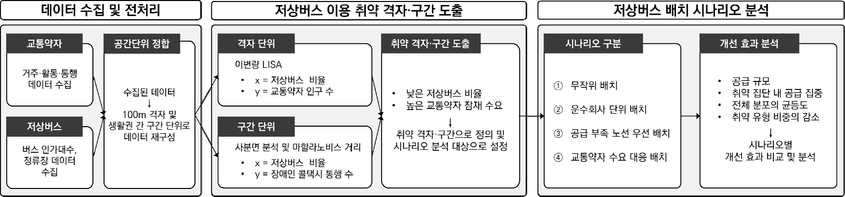
- 저상버스의 도입은 휠체어 이용자와 고령자 등 교통약자의 승・하차 편의를 직접적으로 개선하는 핵심 정책 수단으로 활용되어 왔으며, 이에 따라 저상버스 보급 확대 및 교통약자의 편의 보장을 위한 연구가 이어져왔다. 그러나 저상버스는 한정된 자원 제약 조건 하에서 점진적으로 도입되고 있으며, 이러한 현실을 고려한 각기 다른 배치 전략에 따른 이용 형평성 개선 효과를 분석한 연구는 제한적인 실정이다. 이에 본 연구는 2023년 서울특별시를 대상으로 교통약자의 잠재 수요와 저상버스 공급 간의 공간적 불균형을 100m×100m 격자 단위와 생활권 연결 구간 단위에서 분석하였다. 이변량 국지적 Moran's I와 사분면–마할라노비스 거리 결합 분석을 통해 이용 형평성 취약 격자 및 구간을 도출하고, 수요 기반 배치, 공급 부족 노선 우선 배치, 운수회사 단위 배치, 무작위 배치의 네 가지 시나리오를 설정하여 형평성 개선 효과를 비교하였다. 분석 결과, 교통약자 수요 대비 공급이 부족한 취약 공간에 우선 저상버스를 도입하는 수요 기반 배치 전략 활용 시 이용 형평성이 상대적으로 크게 개선되는 것으로 나타났다. 이는 저상버스 보급 정책에 있어 교통약자의 공간적 수요가 배치 기준 설계의 주요 원칙으로 고려될 필요가 있음을 시사한다.
- COLLAPSE
Low-floor buses have been deployed as a key policy instrument to improve boarding and alighting accessibility for mobility-disadvantaged persons, including wheelchair users and the elderly. However, despite extensive research on bus supply expansion and user convenience, empirical analyses of how alternative deployment strategies under constrained resource conditions affect service-use equity remain limited. This study aims to compare the equity outcomes of alternative low-floor bus deployment strategies in Seoul, South Korea. Using 2023 Seoul data, we measure the spatial mismatch between mobility-disadvantaged demand and low-floor bus supply at two scales: 100 m × 100 m grid units and inter-community corridor units. Equity-vulnerable grids and corridors are identified through bivariate local Moran's I and a combined quadrant–Mahalanobis distance analysis. We then compare four deployment scenarios: demand-based, supply-deficient route priority, transit operator-based, and random. The results show that the demand-based strategy yields the largest improvements across service-use equity indicators. These findings suggest that the spatial demand of mobility-disadvantaged persons should be considered a core principle in the design of low-floor bus deployment criteria.
-
교통약자 수요 기반 저상버스 배치 전략을 통한 이용 형평성 개선효과 분석 - 서울특별시를 사례로 -
-
Research Article
-
지형지시자와 현생 응력장을 고려한 활성 가능 선형구조의 판별
Prioritizing Potentially Active Lineaments Using Geomorphic Markers and Current Stress-Field Constraints
-
이소해, 안재섭, 오정식
Sohae Lee, Jaeseob Ahn, Jeong-Sik Oh
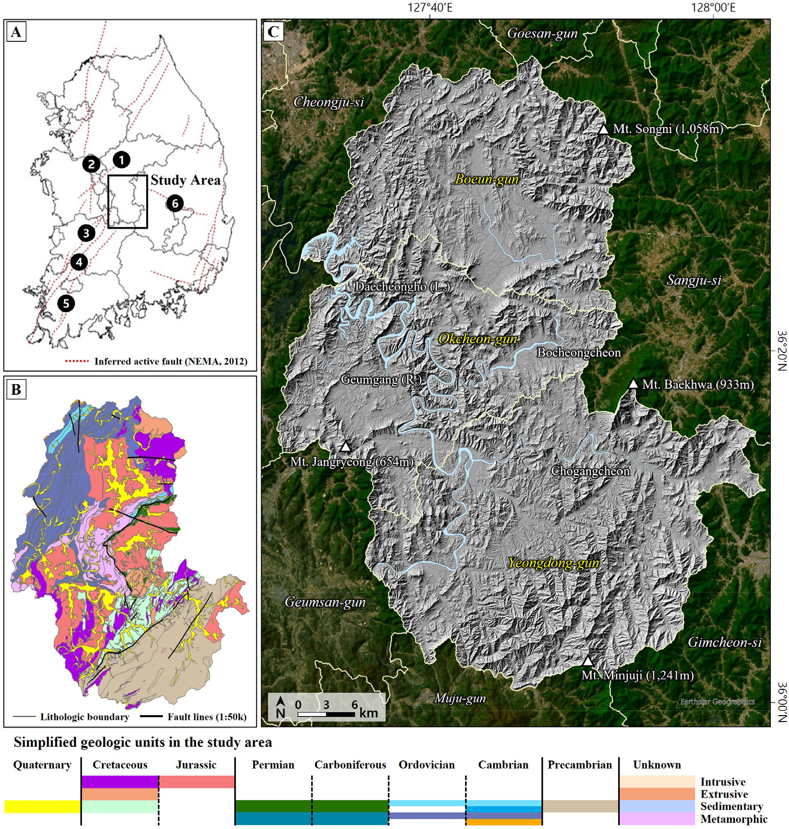
- 판 내부 지역에서는 단층 활동에 의한 지형 변형이 미약하여, 지표에 나타나는 다수의 선형구조 중 단층과 관련된 구조를 판별하기 어렵다. 본 연구는 충청북도 …
In intraplate regions, geomorphic deformation associated with fault activity is often subtle, making it difficult to distinguish tectonically related structures from numerous …
- 판 내부 지역에서는 단층 활동에 의한 지형 변형이 미약하여, 지표에 나타나는 다수의 선형구조 중 단층과 관련된 구조를 판별하기 어렵다. 본 연구는 충청북도 옥천·보은·영동 일대를 대상으로 선형구조 분석, 단층 관련 지형지시자, 현생 응력장 조건을 통합하여 활성 가능성이 큰 선형구조를 판별하였다. DEM 기반 지형 분석을 통해 선형구조를 추출하고 지형지시자 분포를 바탕으로 단층 유형을 해석한 뒤, 이를 현생 응력장과의 기하학적 적합성으로 재평가하였다. 또한, 전기비저항탐사를 통해 천부 지하구조를 검토하였다. 그 결과 연구지역(약 1,967㎢)에서 총 211개의 선형구조가 추출되었으며, 이 중 지형지시자와 응력장 조건을 동시에 만족하는 3개 선형구조가 활성 가능성이 큰 선형구조로 선별되었다. 해당 선형구조에서는 저비저항대가 확인되어 단층 파쇄대와 관련된 천부 지하구조의 존재 가능성이 제시되었다. 본 연구는 선형구조 분석에 지형지시자와 현생 응력장 해석을 결합한 단계적 선별 절차를 제안하며, 광역 지역에서 추출된 다수의 선형구조 중 활성단층 조사 대상의 우선순위를 효율적으로 설정하는 데 효과적인 접근법을 제공할 수 있을 것으로 기대된다.
- COLLAPSE
In intraplate regions, geomorphic deformation associated with fault activity is often subtle, making it difficult to distinguish tectonically related structures from numerous surface lineaments. This study aims to identify potentially active lineaments by integrating lineament analysis, fault-related geomorphic markers, and current stress-field constraints in the Okcheon–Boeun–Yeongdong area of Chungcheongbuk-do, Korea. Lineaments were extracted using DEM-based topographic analysis, and their associated fault types were interpreted based on the distribution of geomorphic markers. These interpretations were then re-evaluated in terms of their geometric compatibility with the current stress-field. In addition, electrical resistivity tomography (ERT) was conducted to investigate shallow subsurface structures. A total of 211 lineaments were identified within the study area (~1,967 ㎢), of which three were selected as potentially active lineaments that satisfy both geomorphic and stress-field criteria. Low-resistivity anomalies detected along these lineaments suggest the presence of shallow subsurface structures associated with fault damage zones. This study proposes a stepwise framework that integrates geomorphic and tectonic constraints for identifying potentially active lineaments, providing an effective approach for prioritizing targets for active fault investigations in broad regions.
-
지형지시자와 현생 응력장을 고려한 활성 가능 선형구조의 판별
-
Research Article
-
하도 형태에 따른 하천생물지형학적 상호작용의 정량화 - 2020년 섬진강 대홍수를 대상으로 정준상관분석의 적용 -
Quantification of Fluvial Biogeomorphic Interactions across Distinct Channel Morphologies using Canonical Correlation Analysis
-
박건우, 김대현
Gunwoo Park, Daehyun Kim
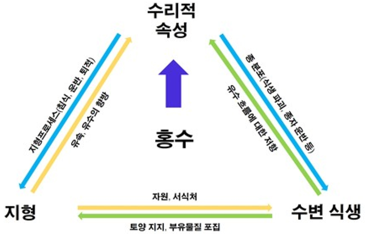
- 하천 생태계는 지형, 수리적 속성, 식생이 복합적으로 상호작용하는 장이다. 하도 형태는 특히 홍수와 같은 교란이 발생했을 때, 이러한 상호작용을 매개하는 핵심적인 요인으로 …
Fluvial ecosystems are governed by intricate, reciprocal interactions among landforms, hydrodynamic processes, and plant communities. Channel morphology plays an important role as …
- 하천 생태계는 지형, 수리적 속성, 식생이 복합적으로 상호작용하는 장이다. 하도 형태는 특히 홍수와 같은 교란이 발생했을 때, 이러한 상호작용을 매개하는 핵심적인 요인으로 작용한다. 지난 2020년 여름, 섬진강에는 대규모 홍수로 유역 전체에 걸쳐 큰 피해가 발생하였다. 본 연구에서는 홍수 당시의 지형, 수리적 속성, 식생 간 상호작용을 정량적으로 평가하고, 이러한 상호작용의 강도와 구조가 직류와 곡류로 대표되는 하도의 형태에 따라 어떻게 다른지 확인하였다. 지형, 수리적 속성 변수를 비생물적 환경 변수군으로, 식생 변수를 생물 변수군으로 나누어 정준상관분석을 수행하였다. 분석 결과, 하도 형태에 따라 비생물적 환경 변수군과 생물 변수군 사이 상호작용이 다르게 나타났으며, 강도와 구조적 측면 모두에서 직류와 곡류 하도 간 뚜렷한 차이를 확인할 수 있었다. 본 연구는 생물지형학적 상호작용을 정량화하는 기법으로 정준상관분석의 유용성을 확인하였으며, 극한 홍수에 대한 하천 생태계의 반응을 조절하는 데 하도의 형태가 미치는 영향력을 강조한다.
- COLLAPSE
Fluvial ecosystems are governed by intricate, reciprocal interactions among landforms, hydrodynamic processes, and plant communities. Channel morphology plays an important role as a mediating factor in these interactions, particularly during flood events. The extreme flooding along the Seomjingang River in 2020 presented a unique opportunity to investigate these dynamics in detail. This study aimed to (1) quantitatively assess the couplings among landform, water flow, and vegetation characteristics during the flood, and (2) examine how the strength and structural organization of these interactions differ between straight and meandering channel segments. Seven variables representing key geomorphic, hydraulic, and vegetation features were measured and subsequently categorized into abiotic and biotic variable sets. Canonical correlation analysis was employed to elucidate the magnitude and structure of biogeomorphic interactions. The results demonstrated that the coupling between abiotic and biotic variable sets significantly varies depending on channel morphology. Distinct differences were observed in both the magnitude and structure of these interactions. This study demonstrates the utility of canonical correlation analysis as a robust approach for directly quantifying complex biogeomorphic relationships and underscores the influence of channel morphology in modulating fluvial ecosystem responses to extreme flood events.
-
하도 형태에 따른 하천생물지형학적 상호작용의 정량화 - 2020년 섬진강 대홍수를 대상으로 정준상관분석의 적용 -
-
Research Article
-
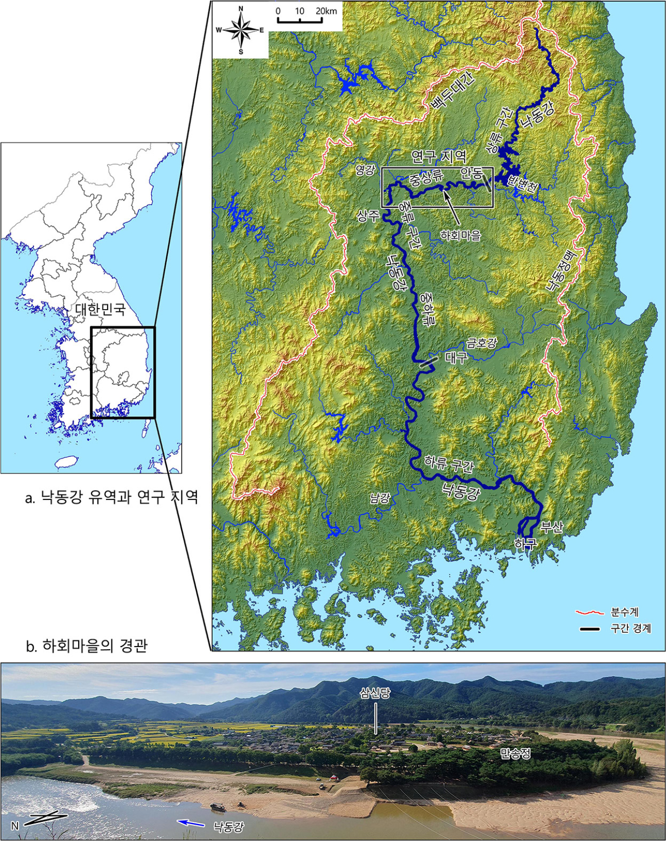
하회마을 일대 낙동강 중상류의 하안단구
Fluvial Terraces in the Mid-upper Reach of the Nakdonggang River near Hahoe Village
-
이광률
Gwang-Ryul Lee
- 유네스코 세계유산인 하회마을의 지형 유형에 대해서는 그동안 다양한 해석이 제시되어 왔다. 본 연구는 하회마을이 위치한 낙동강 본류의 중상류 구간에 대한 하안단구의 분포와 …
Various interpretations have been presented regarding the landform type of Hahoe Village, a UNESCO World Heritage site. This study analyzes the distribution, …
- 유네스코 세계유산인 하회마을의 지형 유형에 대해서는 그동안 다양한 해석이 제시되어 왔다. 본 연구는 하회마을이 위치한 낙동강 본류의 중상류 구간에 대한 하안단구의 분포와 형성 시기 및 형성과정을 분석하였다. 그 결과, 낙동강 중상류 구간에서는 3단의 하안단구 지형면과 1개의 곡류 절단면이 확인되었다. 그리고 홍수위 고도, 하성 원력층의 존재, 단구면의 하상비고 유사성 등으로 판단할 때, 하회마을의 지형은 하안단구 1면으로 확인되었다. 지형면의 최고 하상비고는 범람원이 약 9~10m, 하안단구 1면은 약 17~19m, 2면은 약 30~35m, 3면은 약 50m로 나타난다. 하안단구 1면의 형성 시기는 94ka 무렵이거나 74~96ka의 범위에 해당할 가능성이 크다. 하안단구가 발달한 대부분 지역에서는 낙동강의 생육 곡류 발달 과정을 통해 하안단구가 형성된 것으로 판단된다.
- COLLAPSE
Various interpretations have been presented regarding the landform type of Hahoe Village, a UNESCO World Heritage site. This study analyzes the distribution, formation periods, and processes of fluvial terraces in the mid-upper reaches of the Nakdong River main stream, where Hahoe Village is located. The results identify three levels of fluvial terrace surfaces and one meander cutoff surface in this study area. Based on flood level elevation, the presence of fluvial rounded gravel deposits, and similarities in the altitude above the riverbed of the terrace surfaces, the landform of Hahoe Village was identified as being situated on the fluvial terrace 1. The maximum altitudes above the riverbed for each surface are approximately 9~10m for the floodplain, 17~19m for the terrace 1, 30~35m for the terrace 2, and about 50m for the terrace 3. The formation age of terrace 1 is likely around 94 ka or within the range of 74~96 ka. In most areas where fluvial terraces are developed, they are assumed to have formed through the ingrown meander process of Nakdong River.
-
하회마을 일대 낙동강 중상류의 하안단구
-
Research Article
-
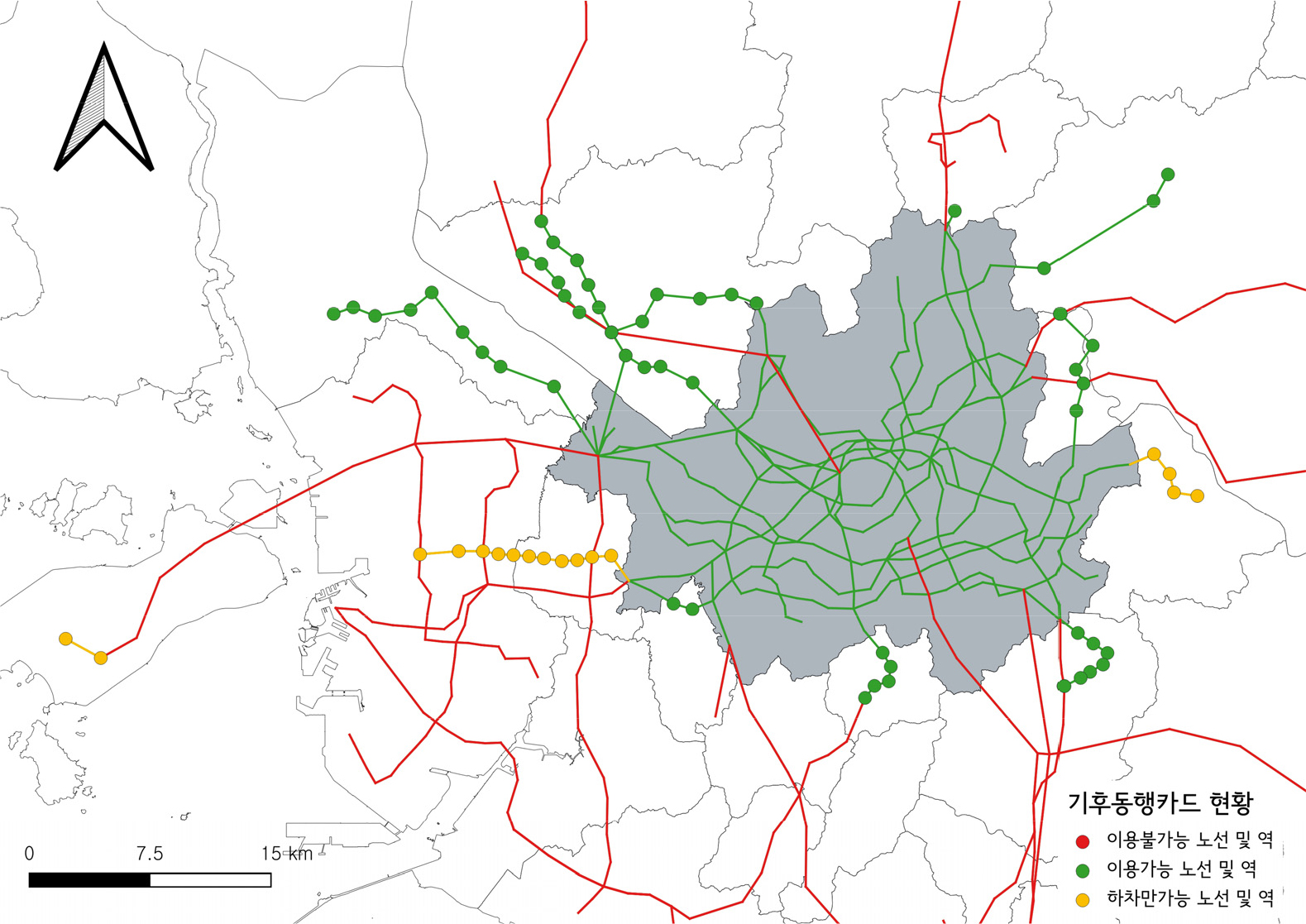
서울시 기후동행카드로 살펴본 신자유주의 대도시권 교통 거버넌스
Neoliberal Metropolitan Transport Governance and Its Everyday Configurations: An Analysis of the Seoul Climate Card
-
신호철, 지상현
Hocheol Shin, Sang-Hyun Chi
- 본 연구는 2024년 서울시가 도입한 기후동행카드를 사례로, 신자유주의적 대도시권 교통 거버넌스의 분절적 구조가 시민의 일상적 이동의 공간 속에서 스스로를 드러내는지 그 형태를 …
Focusing on the “Climate Card”—the unlimited transit pass introduced by the Seoul Metropolitan Government in 2024—this study examines whether and in what …
- 본 연구는 2024년 서울시가 도입한 기후동행카드를 사례로, 신자유주의적 대도시권 교통 거버넌스의 분절적 구조가 시민의 일상적 이동의 공간 속에서 스스로를 드러내는지 그 형태를 분석한다. 그동안의 신자유주의 도시 거버넌스 연구는 기업가주의적 도시 경영전략과 새로운 형태의 민관 거버넌스의 등장을 지적한 바 있다. 그러나 국내에서 이러한 신자유주의 도시 거버넌스가 개인의 일상에서 작동하는 방식을 분석하는 연구는 많지 않았다. 이에 본 연구는 기후동행카드 이용 가능 여부라는 일상적인 주제를 통해 수도권 철도 거버넌스의 구조를 살펴보고자 한다. 이를 위해 2025년 5월 1일 기준 수도권 전철 전 노선의 기후동행카드 이용 가능 여부를 조사하고, 정보공개포털 문서 및 민원 답변 자료를 통해 기후동행카드 이용 가능 기준을 분류하였다. 분석 결과, 역별 이용 가능 여부는 행정구역, 소유권, 운영기관, 협약, 환승역이라는 다섯 가지 기준이 중첩되며 결정되는 것으로 나타났다. 이 복합적 구조는 민영화와 교외화가 누적되며 형성된 파편화된 제도적 경관으로, 서울시는 그 위에서 협약이라는 정치적 수단을 통해 정책 적용 공간을 선택적으로 재구성한다. 이 과정에서 물리적 인프라의 연결성과 행정적 타협이 충돌하는 지점에는 제도적 경계가 지속적으로 재조정되는 ‘회색지대’가 나타난다. 본 연구는 분절적 도시화(Splintering Urbanism) 현상을 대중교통 정책이라는 일상의 영역에 적용함으로써, 신자유주의 거버넌스 담론을 광역교통 생활권과 정책 수혜 범위 간의 불일치라는 시각에서 살펴볼 것을 제안한다.
- COLLAPSE
Focusing on the “Climate Card”—the unlimited transit pass introduced by the Seoul Metropolitan Government in 2024—this study examines whether and in what form the fragmented structure of neoliberal metropolitan transport governance manifests within the everyday spaces of citizens' mobility. While research on neoliberal urban governance has long emphasized the rise of entrepreneurial urban management and reconfigured public–private arrangements, few empirical studies in the South Korean context have analyzed how such governance plays out in individuals' daily lives. To bridge this gap, this study uses the mundane question of where the Climate Card can and cannot be utilized as an analytical window into the governance structure of the Seoul metropolitan railway network. Methodologically, we map Climate Card acceptance across all lines of the metropolitan rail system as of May 1, 2025, and classify the criteria determining card validity by analyzing public information disclosure documents and official responses to citizen inquiries. The analysis reveals that station-level acceptance is shaped by the intersection of five distinct criteria: administrative jurisdiction, infrastructure ownership, operating agency, intergovernmental agreements, and transfer-station status. This composite structure constitutes a fragmented institutional landscape, accumulated through successive waves of privatization and suburbanization, upon which the Seoul Metropolitan Government selectively reconfigures policy space via the political instrument of bilateral agreements. Where the connectivity of physical infrastructure collides with administrative compromises, a "gray zone" emerges in which institutional boundaries are continuously renegotiated. By grounding splintering urbanism within the everyday domain of public transit, this study contributes to the discourse on neoliberal governance by illuminating the spatial and institutional mismatch between the everyday sphere of metropolitan mobility and the reach of policy benefits.
-
서울시 기후동행카드로 살펴본 신자유주의 대도시권 교통 거버넌스
-
Research Article
-
그래프 트랜스포머 기반 표현학습과 연접성 제약 클러스터링 기법을 활용한 수도권 지역화 연구
Graph Transformer-Based Representation Learning and Spatially Constrained Clustering: A Regionalization Study of the Seoul Metropolitan Area
-
전혜민, 이상일
Hyemin Jeon, Sang-Il Lee
- 본 연구는 그래프 트랜스포머 기반 표현학습과 연접성 제약 클러스터링을 결합한 통합적 지역화 프레임워크를 제안하고, 이를 2020년 수도권 1,125개 읍면동 자료에 적용하였다. 기존 …
This study proposes an integrated regionalization framework that combines graph transformer-based representation learning with spatially constrained clustering and applies it to 1,125 …
- 본 연구는 그래프 트랜스포머 기반 표현학습과 연접성 제약 클러스터링을 결합한 통합적 지역화 프레임워크를 제안하고, 이를 2020년 수도권 1,125개 읍면동 자료에 적용하였다. 기존 지역화 연구는 사회・경제적 속성에 기초한 등질지역 접근과 인구 이동 등 공간적 상호작용에 기초한 기능지역 접근으로 나뉘어 발전해 왔으나, 두 접근은 입력 데이터의 구조가 달라 통합적으로 활용되기 어려웠다. 본 연구는 공간 단위를 노드로, 지역 간 인구 이동을 엣지로 하는 지리적 그래프를 구성하고, 그래프 트랜스포머를 통해 각 지역의 사회・경제적 속성, 인구 이동 관계, 그래프 구조 및 지리적 위치를 통합한 지역 표현 벡터를 생성하였다. 이후 이 벡터를 SKATER 알고리즘에 투입하여 공간적 연접성을 만족하는 지역화 결과를 도출하였다. 클러스터 유효도 평가를 위해 전역적 자족도와 SCSA 기반 응집도・분리도 평가를 적용한 결과, k=8, k=13, k=20이 주요 후보로 도출되었다. k=8에서는 수도권의 광역적 하위 권역과 강남 업무지구의 독립성이 확인되었고, k=13에서는 북한 연접 지역, 서해 중부 도서 지역, 서울 남부 신도시 지역 등이 분화되었다. k=20에서는 서울 내부의 삼분 구조, 동탄의 독립성, 서해 북단 도서지역의 특수성이 보다 세밀하게 드러났다. 이러한 결과는 제안된 프레임워크가 등질지역적 유사성과 기능지역적 결속성을 함께 고려하면서, 수도권의 다층적 지역 구조를 공간적으로 연속된 권역으로 도출할 수 있음을 보여준다. 또한 본 연구는 그래프 트랜스포머를 지역화 문제에 적용한 국내외적으로 드문 사례로서, GeoAI 기반 지역 구조 분석의 방법론적 확장 가능성을 제시한다.
- COLLAPSE
This study proposes an integrated regionalization framework that combines graph transformer-based representation learning with spatially constrained clustering and applies it to 1,125 eup, myeon, and dong units in the Seoul metropolitan area as of 2020. Previous regionalization studies have largely followed two separate approaches: homogeneous regionalization based on socioeconomic attributes and functional regionalization based on spatial interactions such as migration flows. To integrate these approaches, this study constructs a geographical graph in which spatial units are represented as nodes and interregional migration flows as edges. A graph transformer is then used to learn regional representation vectors that integrate socioeconomic attributes, migration relationships, graph structure, and geographical location. The learned vectors are subsequently used as input for the SKATER algorithm to derive spatially contiguous regions. To evaluate cluster validity, this study employed global self-containment and SCSA-based compactness and separation measures. The results identified k=8, k=13 and k=20 as major candidate solutions. The k=8 solution revealed broad subregional structures of the metropolitan area and the independent role of the Gangnam business district. The k=13 solution further distinguished areas such as the northern border region, the central western island region, and the southern new-town region of Seoul. The k=20 solution captured a more detailed structure, including the tripartite division of Seoul, the independence of Dongtan, and the distinctive characteristics of the northwestern island region. These results suggest that the proposed framework can incorporate both homogeneous similarities and functional cohesion while deriving spatially contiguous regions that reveal the multi-layered regional structure of the Seoul metropolitan area. In this respect, this study provides a rare example of applying graph transformer-based representation learning to regionalization and demonstrates its potential for extending GeoAI-based regional structure analysis.
-
그래프 트랜스포머 기반 표현학습과 연접성 제약 클러스터링 기법을 활용한 수도권 지역화 연구
-
Book Review

Journal Informaiton
 Journal of the Korean Geographical Society
Journal of the Korean Geographical Society


대한지리학회
#1413, 213-12, Saechang-ro, Yongsan-gu, Seoul, Republic of Korea
Tel: 02-875-1463 / Fax: 02-876-2853 / E-mail: geography77@hanmail.net Copyright© The Korean Geographical Society. Powered by APUB
Tel: 02-875-1463 / Fax: 02-876-2853 / E-mail: geography77@hanmail.net Copyright© The Korean Geographical Society. Powered by APUB