
-
Research Article
-
에이전트 기반 모델을 활용한 군중 대피 패턴 분석 - 고척 스카이돔을 사례로 -
Exploring Crowd Evacuation Patterns Using Agent-Based Model: The Case Study of Gocheok Sky Dome
-
최정호, 강전영
Jungho Choi, Jeon-Young Kang
- 대형 실내 스포츠 경기장은 화재・테러 등 재난 발생 시 관람객 밀집으로 대형 참사로 이어질 위험이 크므로, 좌석 열이 촘촘하고 경사가 큰 다층 …
Large sports arenas are prone to mass-casualty incidents during fires or terrorist attacks because high spectator densities interact with tightly spaced seat …
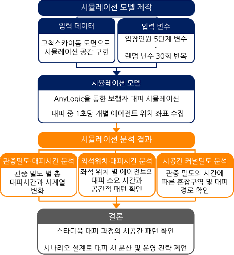
- 대형 실내 스포츠 경기장은 화재・테러 등 재난 발생 시 관람객 밀집으로 대형 참사로 이어질 위험이 크므로, 좌석 열이 촘촘하고 경사가 큰 다층 구조를 고려한 효율적 대피 시나리오 구축이 필요하다. 관중 밀도와 좌석 위치에 따른 건물 구조–관중 상호작용이 만들어내는 시공간적 대피 취약성을 규명하기 위해, 본 연구는 에이전트 기반 모델링(Agent-Based Modeling, ABM)으로 고척스카이돔의 관중 밀도를 중심으로 대피 시간과 시공간 패턴을 분석하였다. ABM은 개별 보행자의 규칙과 상호작용을 반영해 창발적 혼잡의 시공간 전개를 재현할 수 있다. 그 결과, 고밀도 조건에서는 주요 결절점의 혼잡이 심화되며 우회 현상이 나타났고, 40-60% 중밀도 구간에서는 시행 간 분산이 크게 나타나 동선 설계 및 좌석 배치 조정을 통해 개선할 여지가 확인되었다. 본 연구는 관중 밀도와 공간구조의 상호작용이 만들어내는 패턴을 제시함으로써, 안전하고 효율적인 대피 시나리오 설계에 기초자료를 제공하고자 한다.
- COLLAPSE
Large sports arenas are prone to mass-casualty incidents during fires or terrorist attacks because high spectator densities interact with tightly spaced seat rows and steep, multi-level circulation. To quantify the spatiotemporal evacuation vulnerability that emerges from the interaction of crowd density and seat layout, this study develops an Agent-Based Model (ABM) of the Gocheok Sky Dome. The ABM represents individual pedestrians with rule-based movement and local interactions, enabling emergent congestion to evolve through time and space. We simulate multiple crowd-density levels and evaluate evacuation time and spatiotemporal patterns. Under high-density conditions, congestion intensified around key nodes, and detouring behavior emerged. In the medium-density range (40–60%), run-to-run variance is the largest, suggesting substantial potential to improve egress performance through routing design and seat/section allocation. By linking occupancy to emergent patterns, the results provide a basis for safer and more efficient evacuation scenario design for large sports stadiums.
-
에이전트 기반 모델을 활용한 군중 대피 패턴 분석 - 고척 스카이돔을 사례로 -
-
Research Article
-
관계인구의 증가・확대방안과 연구과제
Strategies and Research Tasks to Increase and Expand the Affiliated Population
-
韓柱成
Ju-Seong Han
- 관계인구는 단지 인적 흐름이 아니고 관계성의 재구축을 의미하는 새로운 사회시스템이자 새로운 가치관과 라이프 스타일이다. 본 연구는 농・산촌이 활기찬 과소(過疎)가 되기 위한 하나의 …
The affiliated population is not merely a flow of people, but a new social system that involves rebuilding relationships and represents a …
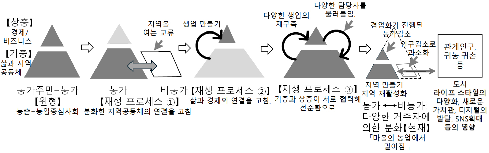
- 관계인구는 단지 인적 흐름이 아니고 관계성의 재구축을 의미하는 새로운 사회시스템이자 새로운 가치관과 라이프 스타일이다. 본 연구는 농・산촌이 활기찬 과소(過疎)가 되기 위한 하나의 지역진흥 수단으로 관계인구의 증가・확대방안을 제시하고 그 활성화 대책과 연구 과제를 밝히는 것을 목적으로 한다. 분석결과는 다음과 같다. 관계인구는 농・산촌의 과제해결이나 매력을 향상시키는데 공헌하는 존재로 지역주민과 공조함으로 지역의 내생적 발전을 유발하고, 지역자원을 발굴해 연마함으로 부가가치가 창출되어 지역 활성화와 연계되는 것을 기대할 수 있다. 그래서 관계인구의 증가는 도농이 서로 보완하면서 지속가능한 사회시스템을 구축하기 위한 중요한 기반이 되는 것을 기대할 수 있는데, 지역방문자들에게 지역의 매력이나 문화를 충분히 이해시키고 이주자가 적은 지역에는 주말이주를 제안하는 틀로도 기대할 수 있다. 그리고 관계인구의 확대・심화의 관점은 인재, 장소, 시스템 만들기로 구성된 연결의 지원과 공유의 역할이 중요하다. 이런 점에서 농・산촌에 존재하는 모습을 실현할 수 있는지 여부나 중장기적인 조치의 효과를 정량적으로 평가해 정기적으로 검토하는 것이 중요하다. 나아가 농・산촌 주민과 새로운 공생관계자인 관계인구와의 사이에는 광역의 공생관계모델로서 새로운 사회(관계)자본의 영역을 구축할 가능성을 시사하고 있다는 점에서 양자에 걸친 종합적 평가방법이 더욱 검토되어야 할 것이다. 그리고 사회네트워크의 약한 유대 강도를 관계인구 네트워크에 적용하면 유효하다고 할 수 있다.
- COLLAPSE
The affiliated population is not merely a flow of people, but a new social system that involves rebuilding relationships and represents a new value or way of life. The purpose of this study is to examine ways to increase and expand the affiliated population as a means of regional promotion, enabling agricultural and mountain villages to become vibrant low-density communities, and to identify related research tasks. The analysis results are as follows. The affiliated population contributes to solving local problems and enhancing the attractiveness of agricultural and mountain villages. It is also expected to induce endogenous regional development through cooperation with local residents, create added value by discovering and refining regional resources, and ultimately contribute to regional revitalization. Therefore, an increase in the number of affiliated people can be expected to serve as an important basis for building a sustainable social system by fostering mutual complementarity between urban and rural areas. It can be expected that this framework enables visitors to fully understand the attractiveness and culture of the region and encourages weekend migration to areas with few migrants. From the perspective of expanding and deepening affiliated populations, the role of support and the sharing of connections—comprising talent, place, and system creation is important. In this regard, it is important to quantitatively evaluate whether the presence of affiliated populations in agricultural and mountain villages can be realized, as well as the effects of mid-to long-term measures, and to regularly review these outcomes. Furthermore, a comprehensive evaluation method for both should be further considered, as it suggests the possibility of establishing new social capital as a model for wide-area symbiotic relationships between villages and affiliated populations. The strength of weak ties in social networks can be applied to affiliated population networks.
-
관계인구의 증가・확대방안과 연구과제
-
Research Article
-
CNN을 이용한 이미지 기반 지형 분류에 관한 연구
A Study on Image-based Landform Classification using CNN
-
정지윤, 박충선
Ji Yun Jeong, Chung-Sun Park
- 본 연구에서는 전국자연환경조사 사진 자료를 바탕으로 CNN을 이용해 이미지 기반 지형 분류를 시도해 보고, 이러한 지형 분류의 한계점 및 의의를 논의해 보았다. …
This study tries to classify image-based landforms using CNN, with photographs from the National Ecosystem Survey, and discusses limitations and implications of …
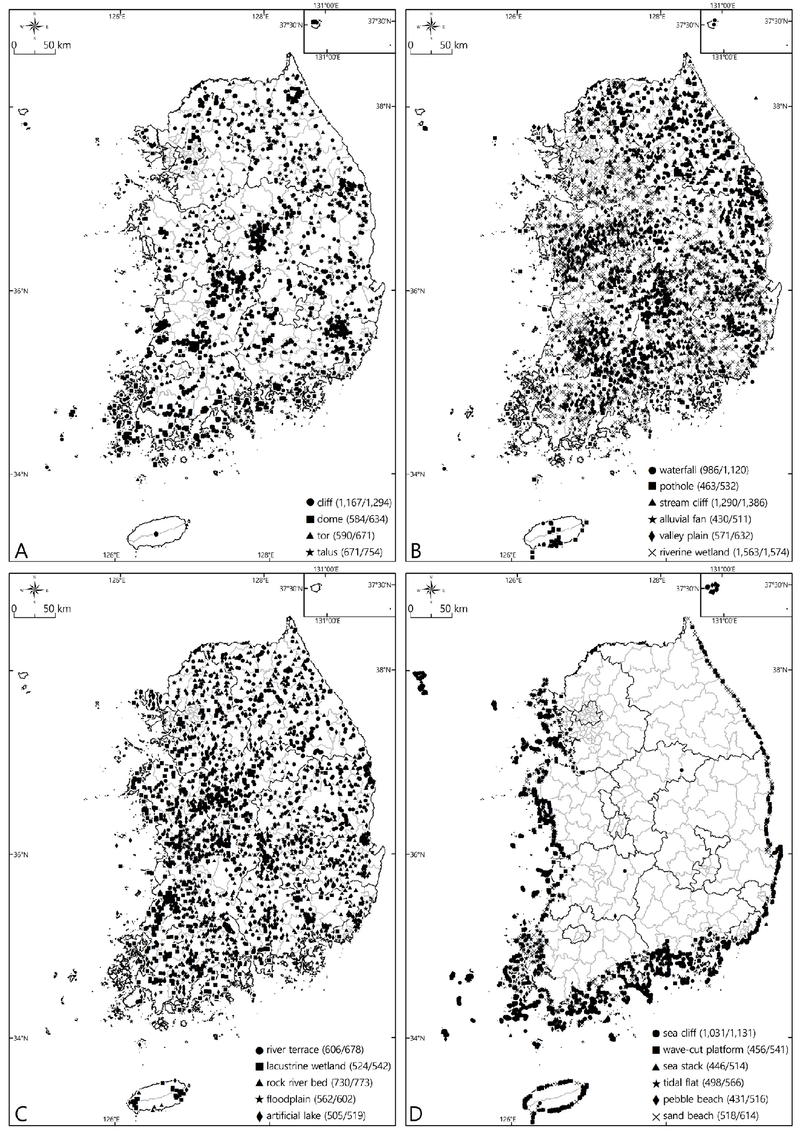
- 본 연구에서는 전국자연환경조사 사진 자료를 바탕으로 CNN을 이용해 이미지 기반 지형 분류를 시도해 보고, 이러한 지형 분류의 한계점 및 의의를 논의해 보았다. 본 연구에서 분석된 21개 종류의 지형 중, 폭포, 인공호수 및 모래해안과 같이 형태적인 요소가 중요한 지형의 분류 정확도는 높은 데 반해, 하안단구처럼 지형을 형성한 작용이 중요한 지형은 낮은 분류 정확도를 보였다. 더구나 공통적인 형태적 특징이 있는 지형은 서로 잘못 분류되기도 하였다. CNN을 이용한 이미지 기반 지형 분류는 사진에서 형태적인 특징만을 고려하기 때문에 분명한 한계가 있지만, 다양한 자료가 추가된다면 지형 분류나 지형 연구에 새로운 가능성을 제시해 줄 수 있을 것으로 기대된다.
- COLLAPSE
This study tries to classify image-based landforms using CNN, with photographs from the National Ecosystem Survey, and discusses limitations and implications of the landform classification. Among the 21 types of landforms used in this study, landforms such as waterfall, artificial lake and sand beach with distinct morphological features show high accuracy, while geomorphic process-dominant landform including river terrace exhibits low classification accuracy. Moreover, misclassification occurs among the landforms with common morphological features. The image-based landform classification using CNN has obvious limitations, because it considers only morphological features on a photograph. However, it is expected that the landform classification will provide new possibilities for landform classification or geomorphic study with the help of various additional data.
-
CNN을 이용한 이미지 기반 지형 분류에 관한 연구
-
Research Article
-
한라・백록 지명고(漢拏・白鹿 地名攷)
Ascertaining the Specific Name Halla and Baengnok in the Jeju Indigenous Language
-
김순배
Sun-Bae Kim
- 본 논문은 한라산과 백록담의 지명 어원이 제주 고유어 지명에서 유래했다는 가설을 설정하여 한자 지명으로 변천해 온 명명 시기, 명명 주체, 명명의 이유, …
Hypothesizing that the place names Hallasan and Baengnokdam are derived from the Jeju indigenous place names, this article aims to elucidate the …
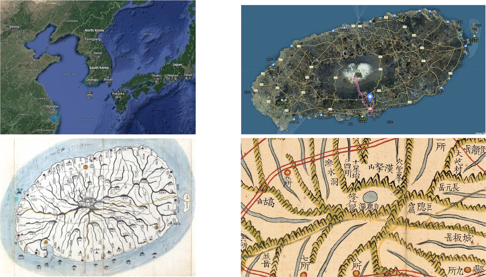
- 본 논문은 한라산과 백록담의 지명 어원이 제주 고유어 지명에서 유래했다는 가설을 설정하여 한자 지명으로 변천해 온 명명 시기, 명명 주체, 명명의 이유, 그리고 본래의 고유어 지명을 역사지리적이고 지명언어학적으로 규명하는 것을 목적으로 한다. 연구 결과를 요약하면 다음과 같다. 첫째, ‘漢拏山’이란 한자 지명은 고려 말에서 조선 초에 이르는 14세기 후반~15세기 초반경에 성리학적 개혁 사상을 가진 신진사대부 및 유학자들에 의해 처음 기록되어 등장했을 것으로 추정된다. ‘漢羅山’은 14세기 말 조선 건국 직후인 1397년에 권근(權近)에 의해 처음 기록된 점과 표기의 특성으로 볼 때 고대 지명 형태소의 음차 표기 형태를 간직한 것으로 보인다. ‘하늘의 은하수를 끌어당길 수 있을 정도로 높은 산(漢拏山)’이라는 지명 인식은 15세기 후반인 1472~1477년경에 처음 등장한 것으로 추정된다. ‘白鹿潭’의 경우, 17세기 초인 1601년에 김상헌(金尙憲)이 쓴 『남사록』에 처음 등장한다. 도가적인 의미를 지닌 ‘신선이 백록에게 물을 마시게 한 못(白鹿潭)’이라는 지명 인식은 1609~1610년에 제주판관을 지낸 김치(金緻)가 지은 「유한라산기」에 처음 등장하는 것으로 조사되었다. 둘째, ‘漢拏山’과 ‘白鹿潭’의 제주 고유어 지명을 각각 ‘큰 땅에 있는 산(오름)’[大地山]을 뜻하는 ‘*한라산~*할라산~*하라산’과 ‘바람못’[風池・風潭]을 의미하는 ‘*ᄇᆞ로못~*ᄇᆞᄅᆞ뭇’이었을 것으로 추정하였다. 또한 ‘漢拏山’의 경우, 조선 초인 14세기 말(1397년)~15세기 중반(1451~1454)에 조선의 도가적인 소양을 지닌 유교적 지식인 및 관료들에 의해 도가적인 가치를 반영한 한자로 전부지명소를 음차 표기한 것으로 추정하였다. ‘白鹿潭’의 경우, 16세기 초(1520~1521)에 제주도 출신의 유학자였던 김양필(金良弼)에 의해 유교적이고 도가적인 상징적 의미와 가치를 지닌 ‘白鹿’(흰사슴)으로 음차 표기된 것으로 추정하였다.
- COLLAPSE
Hypothesizing that the place names Hallasan and Baengnokdam are derived from the Jeju indigenous place names, this article aims to elucidate the naming period, naming agent, reason for naming, and original native place names from a historical-geographical and toponymic perspective, which have been transformed into Chinese character place names. The research results are summarized as follows: First, it is presumed that the Chinese character place name ‘Hallasan (漢拏山)’ was first recorded and appeared in the late 14th century to early 15th century by the new Confucian scholars and scholars who held the Neo-Confucian reformist ideology during the late Goryeo and early Joseon periods. Considering that ‘Hallasan (漢羅山)’ was first recorded by Kwon Geun (權近) in 1397, shortly after the founding of Joseon in the late 14th century, and the characteristics of the notation, it appears to have retained the phonetic transcription form of an ancient place name morpheme. The meaning of a place name like ‘Hallasan Mountain (漢拏山), so high that it can pull up the Milky Way in the sky’ is believed to have first appeared in the late 15th century, around 1472-1477. In the case of Baengnokdam Pond (白鹿潭), it first appeared in Namsarok (南槎錄) written by Kim Sang-heon (金尙憲) in 1601, in the early 17th century. The recognition of the place name as ‘the pond where the Taoist hermit gave the white deer a drink of water’, which has a Taoist meaning, was first found in the Yuhallasangi (遊漢拏山記) written by Kim Chi (金緻), who served as the Jeju magistrate from 1609 to 1610. Second, it was estimated that the Jeju native place names of Hallasan and Baengnokdam were ‘*Hallasan~*Harasan’ meaning ‘mountain (oreum) on a large land’ and ‘*Beoromot~*Beoreomut’ meaning ‘wind pond’. In addition, in the case of ‘Hallasan (漢拏山)’, it is presumed that the prior morpheme of a toponym were written in Chinese characters that reflected Taoist values by Confucian intellectuals and officials with Taoist learning in the early Joseon Dynasty, from the late 14th century (1397) to the mid-15th century (1451-1454). In the case of ‘Baengnokdam (白鹿潭)’, it is presumed that it was written as ‘白鹿’ (white deer) in the phonetic transcription, which has Confucian and Taoist symbolic meaning and value, by Kim Yang-pil (金良弼), a Confucian scholar from Jeju Island in the early 16th century (1520-1521).
-
한라・백록 지명고(漢拏・白鹿 地名攷)
-
Research Article
-
수직적 인클로저의 정치경제학 - 공중공간 자산화와 도시지대 추출 -
The Political Economy of Vertical Enclosure: Airspace Assetization and Urban Rent Extraction
-
최철웅
Cheolung Choi
- 도시 공간의 급격한 수직화에도 불구하고, 공중공간이 어떻게 희소하고 배타적인 권리로 구성되어 지대 추출의 기반으로 기능하는지는 충분히 이론화되지 않았다. 본 논문은 이 공백에 …
Despite the rapid verticalization of urban space, how airspace is constituted as a scarce and exclusive right and becomes the structural basis …
- 도시 공간의 급격한 수직화에도 불구하고, 공중공간이 어떻게 희소하고 배타적인 권리로 구성되어 지대 추출의 기반으로 기능하는지는 충분히 이론화되지 않았다. 본 논문은 이 공백에 개입하여 ‘수직적 인클로저’ 개념을 정식화한다. 수직적 인클로저란 공중공간의 개발 가능성을 도시계획 제도의 차등적 승인을 통해 희소하게 구획하고, 그 배타적 접근권과 수익권을 특정 주체에게 법적으로 귀속시키는 과정이다. 그러나 이러한 권리 구성만으로 지대 추출이 곧바로 이루어지는 것은 아니다. 귀속된 개발 가능성이 경제적 가치로 전환되기 위해서는 자산화의 매개 과정이 필요하다. 본 논문은 공중공간의 자산화를 배타적 권리 구성, 경제적 가치 계산, 미래 수익의 현재 가치화라는 세 계기의 접합으로 이론화하고, 권리의 법적 확정에 선행하여 자본화가 작동하며 이후의 제도적 승인에 영향을 미치는 자기강화적 순환 구조를 논증한다. 이러한 구조 위에서 마르크스주의적 지대의 세 형태—차액지대, 독점지대, 절대지대—를 수직적 공중공간의 차원으로 확장한다. 세 지대 형태는 동일한 제도적 조건으로부터 발생하며 중층적으로 결합된 단일한 지대 구조를 형성한다. 본 연구는 이론적 개념 정식화를 목적으로 하며, 서울의 정비사업을 전형적 사례(Flyvbjerg, 2006)로 활용한다. 이를 통해 논증하는 것은, 공중공간에서의 지대 추출이 자연적 희소성이나 자본 생산성의 차이가 아니라 제도적으로 생산된 희소성과 배타성의 경제적 표현이라는 점이다.
- COLLAPSE
Despite the rapid verticalization of urban space, how airspace is constituted as a scarce and exclusive right and becomes the structural basis for rent extraction has not been sufficiently theorized. This paper addresses this gap by formalizing the concept of vertical enclosure. Vertical enclosure denotes the process through which urban planning systems differentially allocate the development potential of airspace via authorization, legally vesting exclusive rights of access and revenue in designated parties. The conversion of development potential into economic value requires the mediating process of assetization, conceptualized here as comprising three moments: the constitution of exclusive rights, the calculation of economic value, and the capitalization of future income streams into present value. Capitalization operates prior to the formal vesting of rights and forms a self-reinforcing cycle that feeds back into subsequent institutional approvals. On this basis, the paper extends Marx's three forms of rent into the vertical dimension of urban airspace, showing how they arise from the same institutional conditions and are organized into a layered and unified rent structure. Using Seoul's urban redevelopment projects as a paradigmatic case (Flyvbjerg, 2006), this study argues that rent extraction in urban airspace is not an expression of natural scarcity or differential productivity, but the economic manifestation of institutionally produced scarcity and exclusivity.
-
수직적 인클로저의 정치경제학 - 공중공간 자산화와 도시지대 추출 -
-
Research Article
-
중소도시의 압축성과 연계성이 사회적・경제적 활력 수준에 미치는 영향 분석
The Effects of Urban Compactness and Connectivity on Social and Economic Vitality in Small and Medium-Sized Cities
-
홍세환, 손정렬
Sehwan Hong, Jungyul Sohn
- 본 연구는 도시 성과의 구체적 차원으로서 도시 활력에 주목하고, 한국 중소도시를 대상으로 구조적 요인(압축성・연계성)과 사회적・경제적 활력 간의 관계를 실증적으로 분석하였다. 인구 5만~50만 …
Urban social and economic performance is shaped by cumulative interactions in urban space and is closely related to urban structure. This study …
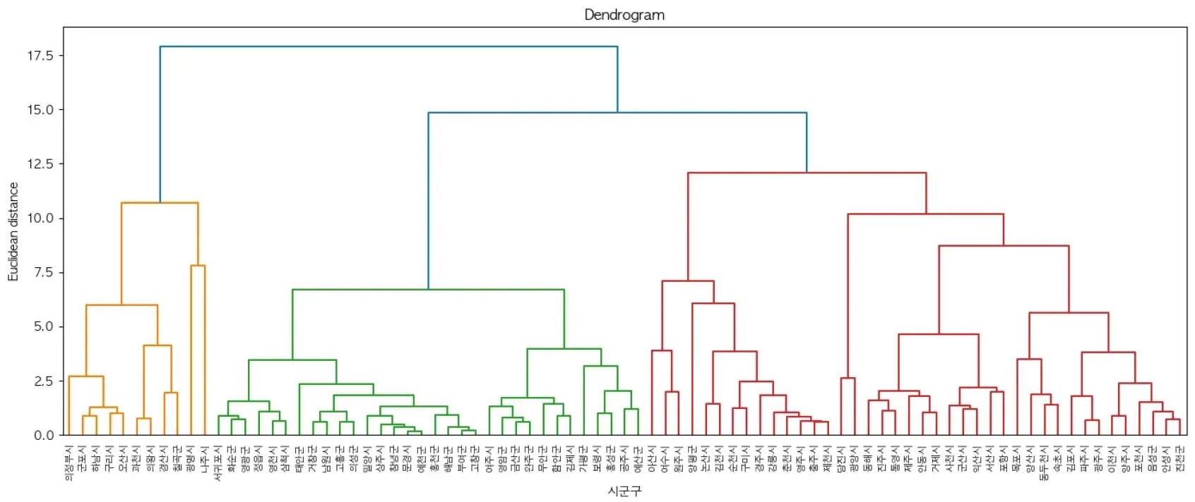
- 본 연구는 도시 성과의 구체적 차원으로서 도시 활력에 주목하고, 한국 중소도시를 대상으로 구조적 요인(압축성・연계성)과 사회적・경제적 활력 간의 관계를 실증적으로 분석하였다. 인구 5만~50만 규모의 중소도시 83개를 대상으로 압축성과 연계성 지표를 수집한 후, 계층적 군집분석으로 도시 구조 유형을 분류하였다. 이후 도출된 도시 구조 유형을 바탕으로 Global/Local GAM 모형을 통해 도시 구조 요인이 사회적・경제적 활력에 미치는 영향을 분석하였다. 분석 결과, 도시 구조 유형별로 관계를 추정한 Local GAM이 Global GAM보다 더 높은 설명력과 적합도를 보였다. 고밀・고연계 구조의 Cluster A에서는 인구 이동이 일정 수준을 넘어서면 사회적・경제적 활력 모두에 부정적으로 작용하는 비선형 반응이 확인되었으며, 저밀・저연계 구조의 Cluster C에서는 구조 지표가 사회적 활력과 경제적 활력에 상반되게 작동하였다. 또한 분석 결과 전반에 걸쳐 동일한 구조 지표라도 도시 유형에 따라 활력에 미치는 영향이 다르게 나타남을 확인하였다. 이는 한국 중소도시에서도 구조–활력 관계가 본질적으로 이질적이며, 도시별 유형과 맥락을 고려한 접근이 필요함을 시사한다.
- COLLAPSE
Urban social and economic performance is shaped by cumulative interactions in urban space and is closely related to urban structure. This study focuses on urban vitality as a specific dimension of urban performance and empirically examines the relationship between structural factors and social and economic vitality in small and medium-sized cities in Korea. For 83 cities with populations between 50,000 and 500,000, indicators of compactness and connectivity were constructed. Urban structural types were identified through hierarchical cluster analysis, and Global/Local GAM models were applied to analyze structure–vitality relationships. The results show that the Local GAM, which reflects urban structural types, provides higher explanatory power and better fit than the Global GAM. In Cluster A (relatively high-density and high-connectivity), population movement shows a nonlinear effect, negatively influencing both social and economic vitality beyond a threshold. In Cluster C (low-density and low-connectivity), structural changes affect social and economic vitality in opposite directions. Overall, the findings confirm the heterogeneity of structure–vitality relationships and highlight the need for type- and context-sensitive approaches.
-
중소도시의 압축성과 연계성이 사회적・경제적 활력 수준에 미치는 영향 분석
-
Research Article
-
핵심 광물의 지리학적 분석 - 텅스텐 글로벌 가치사슬과 영월 상동광산을 사례로 -
Geographical Analysis of Critical Minerals: Global Value Chains of Tungsten and the case of the Sangdong Mine in Yeongwol
-
우정석, 김성훈
Jungsuk Woo, Seonghun Kim
- 본 연구는 천연자원이 핵심 광물로 부상하는 과정에서의 지리적 함의성을 찾고자 한다. 경제 활동은 자원을 다양한 상품과 기술로 변환하는 물질적 변환의 과정이며, 이 …
This study examines the geographical implications of natural resources that have emerged as critical minerals. Economic activities are fundamentally a process of …
- 본 연구는 천연자원이 핵심 광물로 부상하는 과정에서의 지리적 함의성을 찾고자 한다. 경제 활동은 자원을 다양한 상품과 기술로 변환하는 물질적 변환의 과정이며, 이 과정에서 천연자원의 채굴, 가공, 유통, 소비는 복잡한 지리적 네트워크를 통해 이루어진다. 자원 문제는 기술적, 경제적 차원의 문제를 넘어 자원의 생산과 이동, 소비가 이루어지는 공간적 구조와 복잡한 정치・경제적 관계가 얽혀있는 문제이다. 경제 성장, 기술 혁신, 지정학적 관계, 환경 문제 등이 교차하는 지점에 위치한 핵심 광물을 둘러싼 문제들을 이해하기 위해서는 자원의 글로벌 생산-소비 네트워크가 어떠한 지리적 조건 속에서 형성되는지, 그리고 광물은 어떠한 경제적 조건 속에서 ‘핵심’으로 구성되는지 구체적 사례를 통해 분석할 필요가 있다. 이를 위해 본 연구는 텅스텐을 사례로 지정학적 긴장과 지경학적 경쟁이 비중국 중심으로 공급망을 재편하고 있으며, 이러한 변화가 텅스텐을 생산하는 로컬 공간과 산업 구조 재편을 촉진하고 있음을 밝힌다. 결론적으로 핵심 광물은 단순한 천연자원이 아닌, 국제 정치・경제 공간을 이해하는 주요한 지리학의 연구 대상임을 강조한다.
- COLLAPSE
This study examines the geographical implications of natural resources that have emerged as critical minerals. Economic activities are fundamentally a process of material transformation in which natural resources are converted into various commodities and technologies. In this process, the extraction, processing, distribution and consumption of natural resources are coordinated through complex geographical production networks. Issues surrounding resources extend beyond technical exploration and economic supply to encompass the spatial structures and intricate political-economic relations through which resources are produced, circulated and consumed. Critical minerals, positioned at the intersection of economic growth, technological innovation, geographical relations, and environmental concerns, demand an analytical examination on how particular minerals have come to be coordinated as ‘critical’ within specific historical and geographical contexts and how global value chains are being restructured. To this end, this study takes tungsten as a case mineral to demonstrate that geopolitical tensions and geoeconomic competition are reshaping global supply chains toward non-China production networks, and that these changes are driving the restructuring of local space and industrial configurations in tungsten-producing regions. In conclusion, the study argues that the geographies of critical minerals is not merely a matter of resource management, but a key lens through which to understand contemporary international political-economic spaces.
-
핵심 광물의 지리학적 분석 - 텅스텐 글로벌 가치사슬과 영월 상동광산을 사례로 -
-
Research Article
-
대중교통 환승 체계를 반영한 서울시 정신의료기관의 잠재적 공간 접근성 분석
Analysis of Potential Spatial Accessibility to Psychiatric Clinics in Seoul Incorporating Public Transit Transfer Systems
-
유대훈, 송인상
Daehoon Yu, Insang Song
- 한국의 정신건강 지표는 세계 각국과 비교하여 악화 경향이 뚜렷하여 대책에 관한 관심이 증가하고 있다. 정신의료기관은 우울증이나 조현병 등 정신질환이 의심되거나 이환 중인 …
Mental health has become a growing public concern in Korea, as key mental health indicators show concerning trends compared with those of …
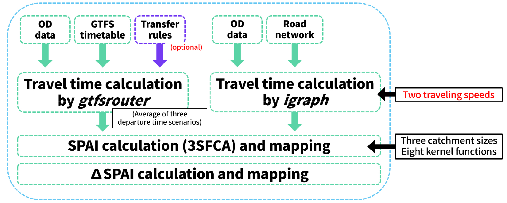
- 한국의 정신건강 지표는 세계 각국과 비교하여 악화 경향이 뚜렷하여 대책에 관한 관심이 증가하고 있다. 정신의료기관은 우울증이나 조현병 등 정신질환이 의심되거나 이환 중인 환자들이 주기적으로 진료와 상담을 받는 장소로서 정신보건에서 중심적 역할을 수행한다. 정신의료기관의 이용률은 지리적 근접성과 밀접하게 연관되어 있으나, 기존 연구에서는 단일 교통수단 이용을 가정한 분석이 주를 이루어 왔다. 그러나 광범위한 대중교통 네트워크가 전체 통행의 상당 부분을 분담하므로 잠재적 공간 접근성을 평가할 때 이용자의 환승 가능성을 고려할 필요가 있다. 본 연구에서는 서울특별시와 인천광역시, 경기도 일부를 대상으로 환승체계를 고려한 다중수단(multimodal) 대중교통을 활용해 정신의료기관의 잠재적 접근성을 평가하고, 기존 단일수단 기반 평가 결과와 비교 분석했다. 3단계유동권역분석법(3SFCA) 모형에 대중교통체계 환승을 반영한 결과 정신의료기관이 집중적으로 분포한 중심지역과 수요인구가 주로 분포한 주변지역 간 연결성이 향상되어 정신의료기관 접근성의 공간적 격차가 줄어드는 것으로 나타났다. 본 연구는 대도시에서의 정신의료기관 접근성 분석에서 환승 반영이 중요함을 강조하며, 기존의 단일 교통수단 기반 분석의 개선 방향을 제시한다.
- COLLAPSE
Mental health has become a growing public concern in Korea, as key mental health indicators show concerning trends compared with those of other countries. Psychiatric clinics play a central role in mental health promotion, as patients and individuals at high risk rely on them for ongoing diagnosis and follow-up care. Although geographic proximity has been shown to influence psychiatric clinic utilization, most studies assessing potential accessibility to psychiatric services have been based on unimodal travel assumptions. Given that the introduction of the integrated transit fare system has significantly reduced travel costs for residents of Seoul and its surrounding areas, transferability between transport modes should be explicitly considered in accessibility assessments. In this study, we incorporated cross-modal transfers into public transit feed data to examine potential accessibility to psychiatric clinics in Seoul under multimodal transit scenarios and to compare the results with those obtained from conventional unimodal approaches. The results indicate that multimodal public transit improves connectivity between major residential areas with high potential demand and central business districts, where most psychiatric clinics are concentrated, thereby reducing spatial disparities in potential accessibility. Overall, these findings suggest that unimodal accessibility assessments risk introducing systematic bias, while accounting for transfers is crucial for accurately evaluating access to psychiatric clinics in metropolitan settings.
-
대중교통 환승 체계를 반영한 서울시 정신의료기관의 잠재적 공간 접근성 분석
-
Research Article
-
강도와 지속성을 고려한 우리나라 복합극한고온현상의 정의, 변화와 전망에 관한 연구
Study on Definition, Change and Future Projection of Compound Extreme Heat Events in the Republic of Korea Considering their Intensity and Duration
-
경예현, 이한수, 이태민, 임동건, 최다솜, 최영은
Yehyun Kyoung, Hansu Lee, Taemin Lee, Donggun Lim, Dasom Choi, Youngeun Choi
-
Human induced global warming has led to greater risks of extreme heat events, which intensify negative impacts on human society and ecosystem. …
-
- COLLAPSE
Human induced global warming has led to greater risks of extreme heat events, which intensify negative impacts on human society and ecosystem. The intensified extreme heat events can lead to prolonged heat conditions, and such compound events often result in amplified impacts. However, the current lack of appropriate indicators to capture characteristics of compound extremes makes it difficult to detect these phenomena accurately and evaluate their potential danger. Thus, we developed two compound extreme heat indicators, Consecutive Heat Event (CHE) and Heatwave (HW) to assess the successive heat occurrence in the Republic of Korea. The national averaged frequencies of CHE and HW indicated significant upward trends, supported by a notable rise after the 2010s. Intensity, severity, and duration of those events also followed increasing pattern to frequencies. Analysis of individual station data reveals that urban areas exhibited the highest vulnerability to compound extreme heat events, primarily influenced by the Urban Heat Island effects. Under the high-emission scenario, robust increases in the frequency of CHE and HW were detected nationwide, accompanied by strengthened intensity and durations of heat events. Even under the lowest-emission scenario, the compound extreme heat events were projected to increase in the near future due to the accumulated greenhouse gas, however they stabilized as the time progressed.
-
강도와 지속성을 고려한 우리나라 복합극한고온현상의 정의, 변화와 전망에 관한 연구

Journal Informaiton
 Journal of the Korean Geographical Society
Journal of the Korean Geographical Society


대한지리학회
#1413, 213-12, Saechang-ro, Yongsan-gu, Seoul, Republic of Korea
Tel: 02-875-1463 / Fax: 02-876-2853 / E-mail: geography77@hanmail.net Copyright© The Korean Geographical Society. Powered by APUB
Tel: 02-875-1463 / Fax: 02-876-2853 / E-mail: geography77@hanmail.net Copyright© The Korean Geographical Society. Powered by APUB