

1. Introduction
2. Geological Setting
3. Methodology
4. Results
1) Surficial evidence of shallow sub-surface fault
2) GPR evidence of subsurface deformation
3) Borehole log interpretation
4) Age of Kushabhadra River paleochannel
5. Discussion
6. Conclusions
1. Introduction
Many workers have studied surface propagation of basement faults in different geological settings (Gawthorpe and Leeder, 2000; Yang et al., 2007; Hardy, 2011; Chatzipetros et al., 2013; Whitney and Hengesh, 2015; Robson et al., 2016 and references therein) using geophysical techniques and field studies. Reactivation of basement faults modify the surface geomorphic architecture by surface propagation and development of secondary faults at the surface level (Gawthorpe and Leeder, 2000). Adequate exposure in hilly terrains makes identifying surface faults relatively easy. Fault mapping is challenging in flat alluvial plains due to low relief and frequent reworking of sediments. Additionally, in areas experiencing less frequent seismic events, surface signatures of co-seismic faults are rapidly modified by the fluvial and eolian activities. Especially in deltaic regions, where fluvial and marine activities are dominant, identification of the influence of different geomorphic agents on fluvial geomorphology becomes difficult. Therefore, preliminary and supporting evidence to study tectonic geomorphology is scarce. In such terrains, morpho-tectonic features and shallow sub- surface geophysical methods have been proved helpful in inspecting active faults (Bano et al., 2000; Goldsworthy and Jackson, 2000; Ganas et al., 2001; Audru et al., 2001; Anderson et al., 2003; Smith and Clark, 2005; Michon and Van Balen, 2005; Leucci and Negri, 2006; Malik et al., 2007; Bhosle et al., 2009; Pati et al., 2011; Yalçıner et al., 2013; Nath et al., 2016, Verma et al., 2017). Fault excavation is a standard procedure in paleoseismological studies. However, finding adequate trenching sites is often tricky in dynamic environmental settings. As faults are buried or eroded in such environments since their last activity, sub-surface structures can be overlooked in trenches.
We choose the N.W. and S.E. coastal sectors of the Mahanadi delta (Fig. 1) to study the ongoing neotectonic activity. Dash and Pati (2018) presented a brief report on the neotectonic activity along the Mahanadi delta using Ground Penetrating Radar and geomorphic indices. However, their study lacked a regional perspective of the neotectonism along the Mahanadi delta, and the chronological constraints were not considered. In addition, topographical dispositions across the faultlines were not taken into account. The present study aims to provide a more detailed account of surface and sub-surface evidence of neotectonism. The N.W. sector of the Mahanadi delta was selected for the study as the presence of active basement structures in the N.W. Odisha makes this region more vulnerable to deformation (Fig. 2a) (Gupta et al., 2014; Dhar et al., 2017; Satyakumar et al., 2022), a number of recent earthquakes have been reported in the N.W. Odisha, and the contact between the basement and cover sediments is very shallow in this region (Mahalik, 2006); suggesting that any deformations in cover sediments can be identified using shallow geophysical techniques. The vulnerability of the near coastal areas of the Mahanadi delta to neotectonism can be argued on the basis of the presence of many active faults in the offshore region of Mahanadi delta (Fig. 2b). Moreover, the Kakinada-Midnapore seismic zone passes through the study area, making the region more vulnerable to seismic activity (Fig. 2c).
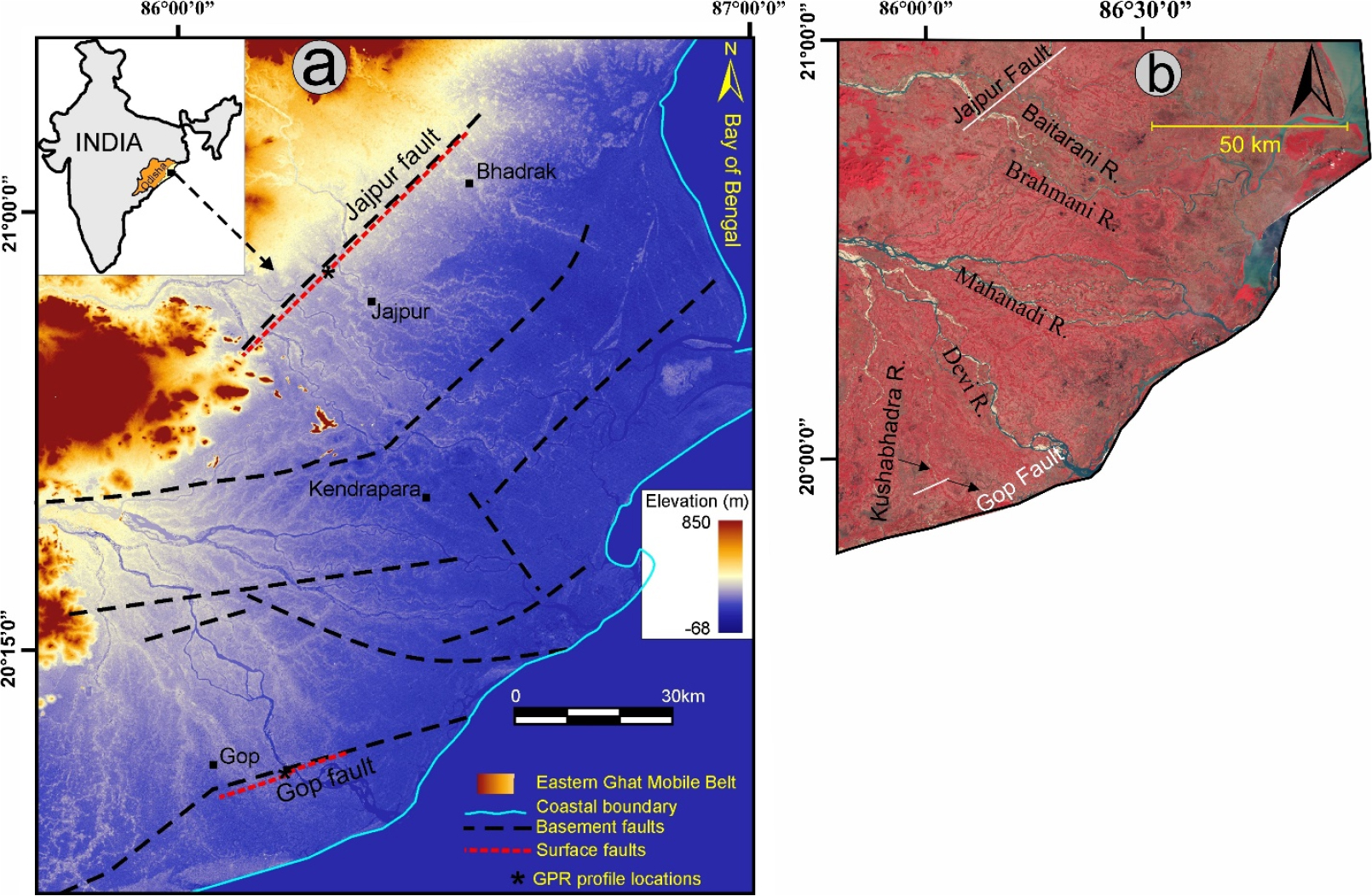
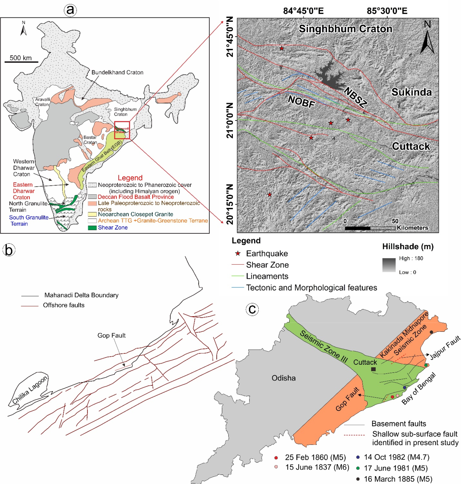
Fig. 2.
(a) Geological map of India showing the cratons and mobile belts (Samal et al., 2019). The rectangle is an outline of structural elements towards the N.W. of the Mahanadi deltaic plain. The zoomed map shows detailed structural features, i.e., faults, lineaments, shear zones, surface geomorphic expressions of the structural elements, and earthquake epicenters on a hillshade image to the N.W. of the study area (Satyakumar et al., 2022); (b) Coast parallel faults in the continental margin of India along the Mahanadi delta (Behera et al., 2004); (c) Map showing the seismic Zone III and the Kakinada Midnapore seismic zone. The basement faults (Seismotectonic Atlas of India) and recent earthquake locations (Data from ASC Website; http://asc-india.org/) in the vicinity of basement faults are shown on the map. (NBSZ = North Boundary Shear Zone; NOBF = North Orissa Boundary Fault).
As India's coastal plains are increasingly populated (The state of Odisha has a population density of 410 persons/ km2 in the coastal areas) and selected for growing economic hubs, seismic vulnerability assessment in the region is the need of the hour. Further, recent reports of land subsidence, tilting, and damage to infrastructures (Table. 1) in the coastal regions of India, add more emphasis to the present work and demand a detailed seismotectonic evaluation of this area on an urgent basis (Bharali et al., 1991; Vaidyanadhan and Ghosh, 1993; Kumar and Bhatacharya, 2003; Mahalik, 2006).
Table 1.
Publications in national newspapers regarding various geological hazards along the Odisha coast
2. Geological Setting
This study is confined to the coastal plains of Odisha (east coast of India). The Mahanadi Delta is an eastward sloping (gently) plain consisting of unconsolidated to semi-consolidated alluvium, deposited by the rivers like Mahanadi, Brahmani, Baitarani, and their distributaries. This coastal plain is limited by the Eastern Ghat Mobile Belt (EGMB) to the west and the Bay of Bengal basin to the east (Fig. 2). The basement is traversed by many NE-SW trending faults, forming horst and graben structures (GSI, 2000). Basement depth below the alluvium varies from nearly zero in the western part to more than 2500 m near the coast.
Gravity, magnetic, and seismic refraction studies suggest these basement faults were reactivated in the geologic history (Bharali et al., 1991; Satyakumar et al., 2022). Seismic activities in the Bay of Bengal region and N.W. Odisha (around the North Orissa Boundary Fault) (Gupta et al., 2014; Dhar et al., 2017; Satyakumar et al., 2022) and movements along the coast parallel faults (Subrahmanyam et al., 1993) have the potential to deform the deltaic cover sediments. In addition, the historical records of many near coastal earthquakes in the Mahanadi delta suggest ongoing neotectonic activity in the region. This study area falls in the seismic zone-III in the seismic atlas of India and hence is seismically moderately active (Anon, 1998).
3. Methodology
Surface fault identification in the hilly terrain is relatively easy due to the availability of adequate exposures. But in coastal plains experiencing intense fluvial activity, any accommodation space created due to surface faulting is rapidly filled by sediment remobilization. Because the study location is a low-altitude coastal plain with few exposed deformation structures, conventional morpho- tectonic approaches including remote sensing and Geographic Information System (GIS) were utilized to gather evidence for surface signs of sub-surface faulting. Fluvial channels are very sensitive to tectonic activity; hence the analysis of Longitudinal River Profile (LRP) is a universally practiced tool in neotectonic research (Demoulin, 1998; Holbrook and Schumm, 1999; Viveen et al., 2012; Fekete and Vojtko, 2013; Goren et al., 2014). If the rate of river bed uplift exceeds the incision capability, a convex longitudinal profile develops (Whittaker et al., 2007). In particular, the convex segments are called knick points or knick zones, depending upon their length. The knick points can be investigated to evaluate their coincidence with tectonic perturbations at scales ranging from the whole chain to local structures (Molin and Fubelli, 2005). The longitudinal profiles of rivers were studied using Google Earth elevations. The rivers with dominant sand bars were avoided for the longitudinal profile study. In areas with low topographic elevations, the profiles drawn across the faults have been proved to be helpful in indicating the change in surface slopes. Topographic breaks across the shallow faults have been proved to be a useful morphotectonic parameter in the Indo-Gangetic plains (Pati et al., 2018, 2019; Patel et al., 2020). We analyzed topographic breaks from Digital Elevation Models generated using Survey of India Toposheets for this study. Ground Penetrating Radar (GPR) survey was carried out to explore the nature of the sub-surface deformation structures. Borehole logs obtained from Central Ground Water Board were used to study the nature of the basement fault and its effect on sediment deposition patterns.
Since the Kushabhadra River demonstrates channel avulsion while crossing the Gop fault (Fig. 1b), we infer that probable slope change across the faultline may have afforded space for channel avulsion in near-coastal environments. As a result, the age of the Kushabhadra River paleochannels will provide information about the late Quaternary activity along the Gop fault. Only one sample from the Kushabhadra River paleochannel crossing the Gop fault was used for Optically Stimulated Luminescence chronology study. The sampling for OSL chronology was carried out from a trenched section along the paleochannel. The detailed methodology for OSL chronology sample preparation is explained elsewhere (Murray and Wintle, 2000; 2003). Briefly, carbonate and organic fractions from the sediments were removed using Hydrochloric acid and Hydrogen peroxide (30%), respectively. The samples were further wet sieved to obtain 90-150 micron grain size. Pure Quartz was obtained using density separation method (with Sodium polytungstate salt). We used the IISER Kolkata OSL/TL laboratory for OSL measurements (details of instrumentation settings and parametrization are mentioned in Resmi et al., 2017).
4. Results
1) Surficial evidence of shallow sub-surface fault
Tectonic geomorphology is being used as a valuable tool to assess the tectonic activity of any region, especially in flat plains (Burbank and Anderson, 2001; Keller and Pinter, 2002; Singh et al., 2006; Bhosle et al., 2009; Azañón et al., 2012; Pati et al., 2015). Surface movements produced by the activity of growing faults affect the topography as well as modify the drainage (Jackson and Leeder, 1994). As the present study area is experiencing less frequent seismic events, surface signatures of co-seismic faults are rapidly modified by the fluvial and eolian activities. Therefore, evidence of fault scarps rarely exists. Tectonic geomorphological parameters used to identify surface positions of the fault are discussed below.
In the present study, LRP prepared from Google Earth for rivers Kharsuan and Shalandi show local convexity across the Jajpur fault (Fig. 3a and b). We did not choose other large rivers in the study area for longitudinal profile study as sand bars are prominent in these rivers, which may obliterate the longitudinal profiles. The LRP across the Kushabhadra River did not show any changes in the river profile (Fig. 4a and c). Topographic profiles were generated in the study area from the DEMs generated using the point heights from Survey of India Toposheets (Fig. 3d and 4d), and significant breaks in slopes were recognized. Based on the changes in LRP and topographic breaks, we inferred the probable presence of a near-surface fault/deformation structures (the Jajpur Fault and Gop Fault). The prominent rivers also show channel offsets and the development of paleochannels across the fault. To further confirm and characterize the near-surface deformation structure, we carried out a Ground Penetrating Radar survey across the inferred fault.
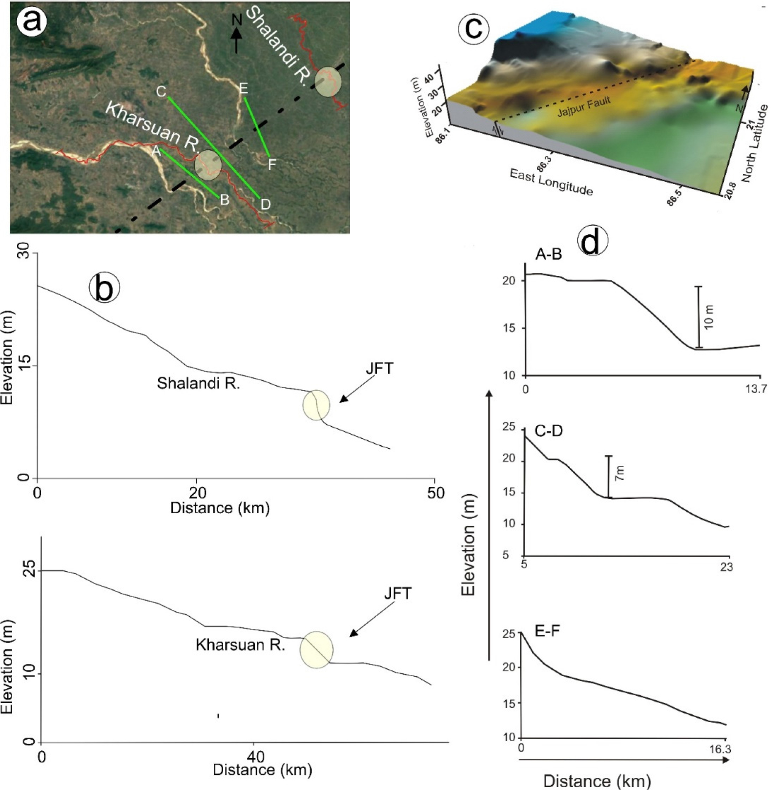
Fig. 3.
(a) Segment of the Kharsuan and Shalandi Rivers analyzed for river longitudinal profile. A-A, B-B, and C-C are the sections along which surface topographic profiles are constructed; (b) Longitudinal river profiles of the rivers crossing the Jajpur fault; (c) 3D digital elevation model around the Jajpur fault; (d) Surface topographic profiles drawn across the Jajpur fault.
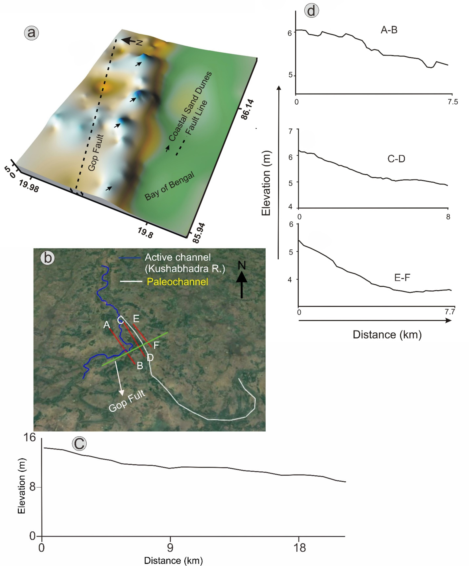
Fig. 4.
(a) 3D digital elevation model around the Gop fault; (b) The segment of the Kushabhadra River analysed for river longitudinal profile. A-A, B-B, and C-C are the sections along which surface topographic profiles are constructed; (c) Longitudinal river profiles of the rivers crossing the Gop fault; (d) Surface topographic profiles drawn across the Gop fault.
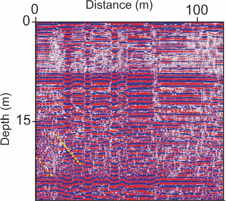
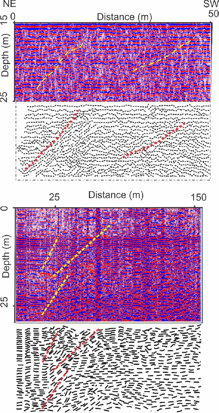
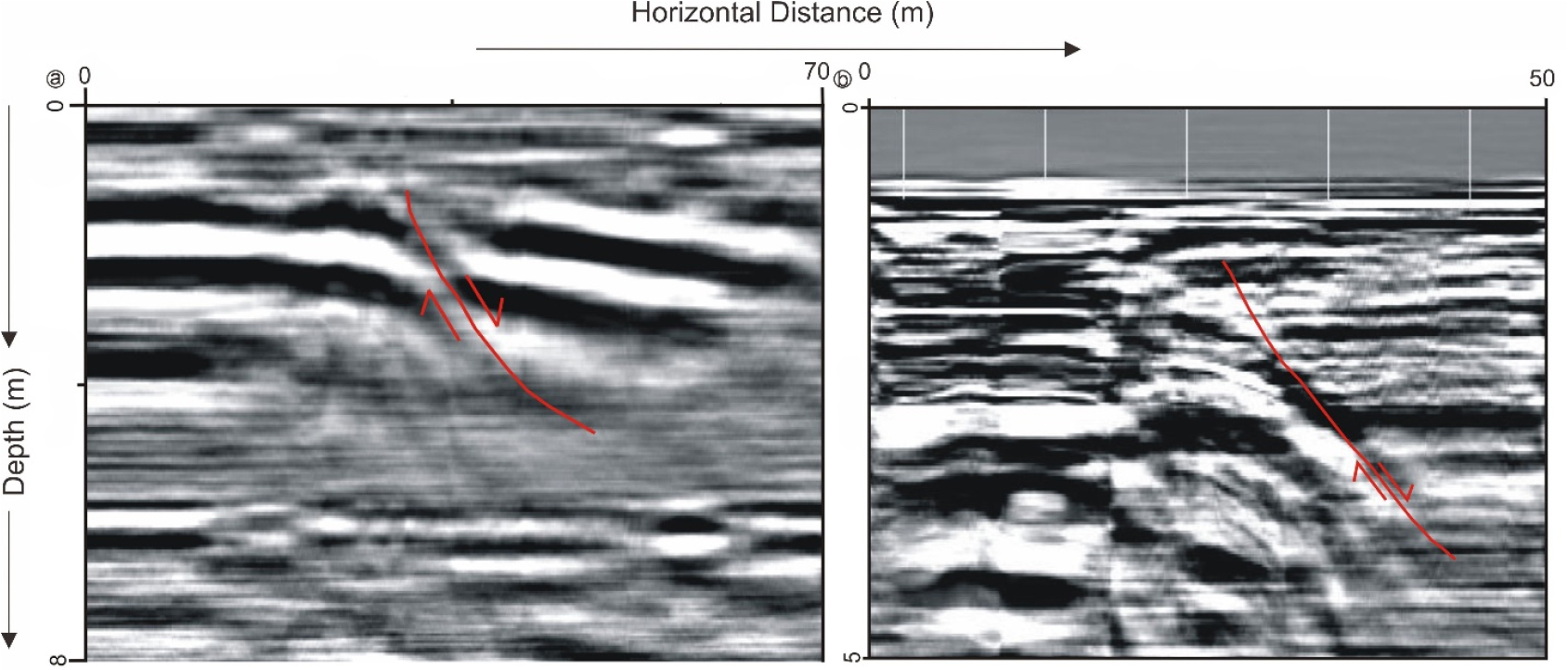
2) GPR evidence of subsurface deformation
GPR survey was used to study the subsurface position and nature of the fault. GPR profiles were taken across the inferred sub-surface deformations in the fault zone identified from the remote sensing and GIS studies and subsequent field works (Fig. 1). GPR survey was carried out in distance mode (survey wheel model 620, GSSI) by 100 MHz antennae, which gives the best tradeoff between penetration depth and resolution (Bristow and Jol, 2003). Automatic gain control was applied during data acquisition. Several test profiles were collected and analyzed to determine the best acquisition parameters for the survey. GPR Manual Version 5.0 with computer-based RADAN software was used for processing the collected data as described by Fisher et al. (1994).
250 m long GPR traverses across the inferred Gop fault and Jajpur fault show displacements in sub-surface strata (Fig. 5 and 6). Deformation structures around the Gop fault were observed below 15 m from the surface. Deformation structures in all the GPR profiles across the Gop Fault indicate that deformation occurred in a zone. In contrast, the GPR profiles across the Jajpur fault show deformation structures at a shallower level, around 5 to 10 meters below the surface. More than one-meter net vertical displacement is observed in the subsurface strata at both locations. The observed faults strike parallel to the basement faults and dip eastward towards the coast (Fig. 7). As the subsurface materials across the faults are the same in both locations, no perceptible velocity change is noticed in the GPR profiles.
3) Borehole log interpretation
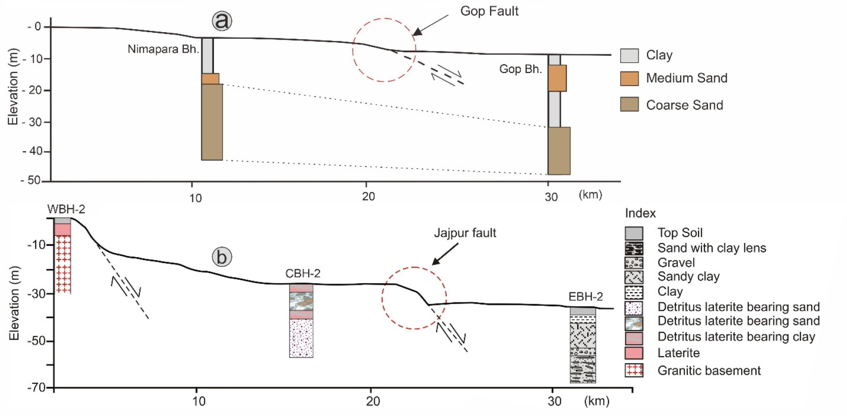
Borehole logs collected from the Central Ground Water Board (CGWB) were interpreted to decipher if there are any sub-surface discontinuities in the lithology across the deformation zone. The lithologies across the Gop fault show fluvial sediments of sand and clay (Fig. 8a). The thickness of the clay at the downthrown side of the fault is nearly twice that of the upthrown side. The basal coarse sands also show a similar deposition pattern across the fault, i.e., at a shallower depth on the upthrown side and a deeper depth on the downthrown side. General lithology across the Jajpur fault consists of a granitic basement overlain by lateritic sediments, and the fluvial deposits comprised of sand and clay occupy the topmost part. Three logs across the Jajpur fault, at about 10 km intervals, show a significant change in the lithology. The basement at the WBH-2 lies close to the surface, whereas at EBH-2 lies at a much deeper level (Fig. 8). The top lateritic layer at WBH-2 is not observed in CBH-2 or EBH-2. Instead, eroded laterite-rich clay is observed along the downthrown side of the fault. This implies that either the lateritic layer at the upthrown side was detached and altered by pedogenic processes or eroded and deposited in the downthrown side. The borehole towards the east (EBH-2) shows deposition of fluvial sediments.
4) Age of Kushabhadra River paleochannel
Dose rate calculation of the OSL sample from the Kushabhadra paleochannel was done using ICPMS measured U, Th, and K concentrations (U:0.9 ± 0.011 ppm, Th:11.12 ± 0.061 ppm, K:1.91 ± 0.048 %). The equivalent dose obtained using OSL measurements was found to be 17 ± 1 (Gy) using the SAR protocol given by Murray and Wintle (2000, 2003). The calculated age was found to be 7.4 ka (Fig. 9).
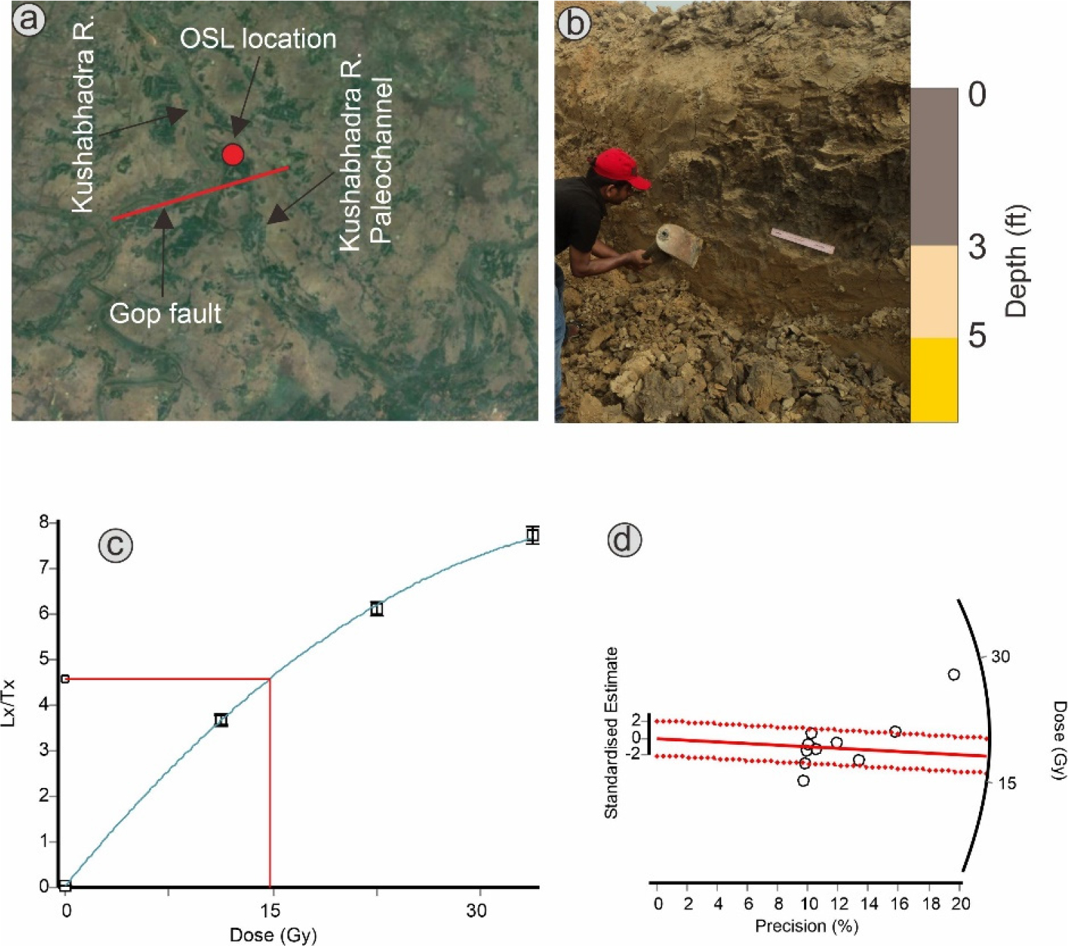
Fig. 9.
(a) Location of OSL sampling point on the Kushabhadra paleochannel; (b) Trenching for OSL sample collection, (c) Growh curve for OSL sample from Kushabhadra paleochannel; (d) The distribution of equivalent dose (De) values for all samples presented with radial distribution pattern. The equivalent dose was obtained using the central age model.
5. Discussion
In this study, we discuss the development of a shallow sub-surface deformation structure in the coastal sediments of the east coast of India. Due to the unavailability of exposure, an integrated approach has been adopted using remote sensing, GIS, borehole logs, and GPR to establish the nexus between the basement fault and the shallow sub-surface deformation. The GPR profiles at the two locations reveal the presence of listric faults, dipping towards the coast. These coastward dipping faults are parallel to the basement structures, suggesting that a possible reactivation of the basement fault in the Quaternary propagated the secondary deformations to the surface.
Although surficial expressions of the faults are unavailable, the geomorphic alterations seen in the fluvial morphology are significant. Rivers such as Kharsuan and Baitarani offset about 4 km along the Jajpur fault. The longitudinal profiles of rivers across Jajpur fault show significant breaks, suggesting that low magnitude deformations altered the river bathymetry. The longitudinal profile across the Kushabhadra River, which is near the coast, did not show any changes as the sedimentation rate in near coastal settings is adequate to fill the accommodation space created by the faulting event.
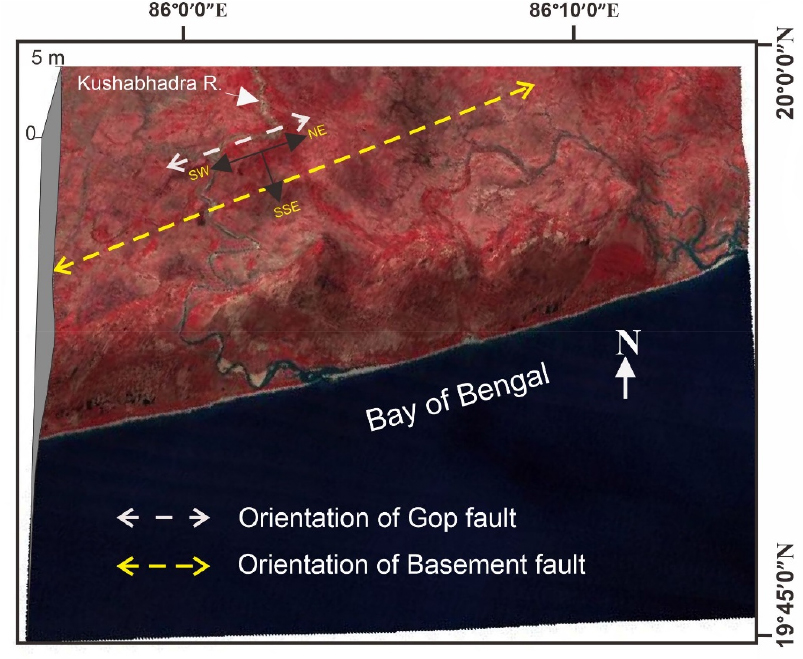
The OSL age of the Kushabhadra paleochannel suggests that the last channel shifting occurred around 7.4 ka B.P. As the Kushabhadra River flows across the Gop fault, which creates significant breaks in the topographic profile, the mid-Holocene channel avulsion process could have been supplemented by a possible slope change across the fault. Hence it can be inferred that, although seismic activities are infrequent in the Mahanadi delta region, the late Quaternary geomorphic changes were triggered by the basement fault activation. Since the coastal rivers are at a low energy state and are acted upon by multiple endogenic forces, factors like slope change would supplement fluvio-architectural reconstruction. It can be debated that feeble slope change may not cause channel avulsion, but if triggered by factors like base level change (Dash et al., 2020), the fluvial channels would follow the preferred topographic slope. As can be seen in the 3D digital elevation model (Fig. 10), the Kushabhadra River follows the slope break across the Gop fault, which is parallel to the orientation of the basement fault. This implies that, even though coastal topographic alterations in response to late Quaternary reactivation of basement faults would have been minor, compelled by autogenic/allogenic forces the fluvial channels followed the topographic slopes reshaped by neotectonism.
Historical records of recurrent earthquakes in the region suggest that although infrequent, the neotectonic activity occurred in the background of fluvio-geomorphic construction of the delta. Digital elevation models and the surface topographic breaks are prominent across the Jajpur Fault. Perhaps the sediment remobilization in the near coastal settings around the Gop fault obscured the surficial signatures of the subsurface deformation. Lithology interpretation across the faults shows differences in the depositional pattern of the sediments across the faults. The sediment thickness above the basal parent material on the downthrown side is nearly twice than that on the upthrown side. The accommodation space created due to sub- surface deformation offered a higher sedimentation rate at the downthrown side of the fault. The striking feature observed in the lithologs across the Jajpur fault is the differences in the basement depth on the upthrown and downthrown sides.
The presence of basement faults in this area has been well established by Bharali et al. (1991) and the Geological Survey of India (2000) by different geophysical techniques. The Mahanadi Graben is bound by North Orissa Boundary Fault to North and the Mahanadi Shear zone to the south. The graben is characterized by a number of surface and sub-surface deformational structures (Fig. 2). The deformational structures include surface and sub-surface faults, shear zones, and thrusts, shaping the topography of the Mahanadi basin. The graben experiences recurrent seismicity due to the reactivation of structures beneath the eastern ghat mobile belt (Sarkar et al., 2007; Gupta et al., 2014). Seismicity of magnitude 3-6 has been recorded in recent history (Satyakumar et al., 2022). The presence of surface and sub-surface deformation structures have shaped the geomorphology of the basin and can be mapped using remote sensing images. The activity along these surface and sub-surface structures make the Mahanadi delta vulnerable to seismic activities and warrants seismotectonic evaluation of this sector. Moreover, less intense fluvial activity in the western and N.W. sector of the Mahanadi delta offers a good preservation potential for any topographic alterations due to neotectonic activity. While, the eastern and southern sectors are dominated by intense fluvial activity, where any evidence of surface/ sub-surface deformation are obscured with time.
The Mahanadi basin has buried basement faults which reactivated during Tertiary and Quaternary periods, as evident from gravity, magnetic, and seismic refraction studies (Bharali et al., 1991). These faults are reactivated in response to the ongoing northward movement of the Indian plate and trigger small magnitude earthquakes. Twelve historical earthquakes have been recorded from 1837 to 1992 due to the activities of these faults (Anon, 1998). “Basement fault reactivation in the subsurface may either cause the upward propagation of basement-involved normal faults or the nucleation of a vertically isolated normal fault array in shallow cover sediments directly above the reactivated basement-involved faults” (Robson et al., 2016). The resulting deformation in both cases causes local or regional uplift or subsidence (Chatzipetros et al., 2013). Thus, it is believed that the near-surface deformation observed in the present study is either the continuation of the basement faults to the surface through the covered sediment or the generation of new faults on the surface due to basement fault reactivation (Fig. 2).
Numerous studies have shown that the development of parallel striking normal faults occurs in the sediment cover above the basement normal faults due to increased flexure, gravity gliding, and tilting of cover sediments (Vendeville et al., 1995; Withjack and Callaway, 2000). The mechanism of basement fault reactivation and propagation to the surface is well explained by Gawthorpe and Leeder (2000). Active faults promote subsidence along the coastal plains and enhance the erosion rate (Dokka et al., 2006; Dokka, 2006; White and Tremblay, 1995; Closson, 2005; Kuecher et al., 2001). As the coastal plain of Odisha is mainly composed of unconsolidated sand and clay, frequent subsidence has been reported close to the coast (Table 1). Loss of land to sea has now become a more recurrent phenomenon (Mohanti, 1993), which too may have been partly contributed by subsidence of the region. Many researchers have discussed the effect of faults on fluvial geomorphology, landscape modification, coastal subsidence, loss of land to sea, and infrastructure damage along the coastal tracts of India (e.g., Valdiya and Narayana, 2007; Resmi et al., 2017). As this region is tectonically less active, the development of faults and their influence on a wide spectrum of geological problems demands a seismotectonic re-evaluation of the region.
6. Conclusions
a. Near surface faults identified in the present study are parallel to the basement faults, suggesting their possible Quaternary reactivation.
b. The surface evidences of geomorphic alterations across the Jajpur fault are more prominent. Intense fluvial activity across the Gop fault altered the sediment depositional pattern, rapidly filling the accommodation space.
c. In terrains with lower relief and negligible slope where sub-surface deformations are not exposed to the surface, an integrated approach using remote sensing, GIS, and GPR is helpful in mapping active faults.
d. Because coastal rivers are in low-energy state and are influenced by various endogenic and exogenic forces, attributes such as slope change could amplify fluvio-architectural reconstruction.
