
-
Research Article

-
지리적 관점에서 본 국가유산 기후변화 대응의 현안과 도전과제
A Geographical Consideration and Suggestion on Current Issues and Challenges to Cope with Climate Change for National Heritage
-
김지수
Jisoo Kim
- 우리나라의 국가유산은 기후변화로부터 다양한 영향을 받고 있다. 국제사회는 이에 대한 논의를 유네스코 세계유산위원회를 중심으로 진전시켜왔으며, 우리나라도 2050 탄소중립 선언 이후 유산 분야에서의 …
The national heritage of Korea is being influenced by various aspects of climate change. The international community has advanced discussions on this …
- 우리나라의 국가유산은 기후변화로부터 다양한 영향을 받고 있다. 국제사회는 이에 대한 논의를 유네스코 세계유산위원회를 중심으로 진전시켜왔으며, 우리나라도 2050 탄소중립 선언 이후 유산 분야에서의 정책적 대응과 연구를 강화하고 있다. 지리적 관점에서 국가유산의 기후변화 대응을 위해 단기적으로 GIS 기반의 공간정보 활용과 위험 평가도구 개발, 유산 보존・관리 방법론의 간학문적 검토, 탄소배출 감축이 필요하다. 중장기적으로는 체계적・순환적 모니터링 체계 구축, 기후변화 대응 항목의 유산 체계에의 적용, 전통지식과 지속가능한 방식 탐색, 자연기반 해법 적용방안 모색이 중요하다. 또한 장소기반 접근방식에 근거하여 유산지역 너머의 공간적 맥락을 고려한 대응조치를 탐색하고 지역공동체와의 협력을 고려해야 할 것이다.
- COLLAPSE
The national heritage of Korea is being influenced by various aspects of climate change. The international community has advanced discussions on this through the UNESCO World Heritage Committee, and Korea has strengthened its policy responses and research in the heritage sector since the 2050 carbon neutrality declaration. From a geographical perspective, short-term responses to climate change for national heritage require active utilization of GIS-based spatial information, development of risk assessment tools, interdisciplinary exploration of methodologies for heritage conservation and management, and carbon emission reduction. In the medium to long term, it is important to establish a systematic and cyclical monitoring system, integrate climate change response elements into the heritage system, explore traditional knowledge and sustainable practices, and seek nature-based solutions. Furthermore, based on a placed-based approach, efforts should be made to explore response measures considering the spatial context beyond heritage sites and to consider collaboration with local communities.
-
지리적 관점에서 본 국가유산 기후변화 대응의 현안과 도전과제
-
Research Article

-
청년 귀농후계농가의 경영형태 전개
Progression in Management Techniques of Young Return-to-Farm Successors
-
韓柱成
Ju-Seong Han
- 본 연구는 청년 귀농후계자로서 가업승계자와 영농 신규 후계자를 대상으로 이들이 경영자원 기본요소로서 인적자원, 무형재산 및 유통・판매에 의한 영농활동에서 어떠한 특성을 나타내는지 경영형태의 …
The purpose of this study is to see characteristics between successors of family farm business and new immigrant farmers. The differences are …
- 본 연구는 청년 귀농후계자로서 가업승계자와 영농 신규 후계자를 대상으로 이들이 경영자원 기본요소로서 인적자원, 무형재산 및 유통・판매에 의한 영농활동에서 어떠한 특성을 나타내는지 경영형태의 전개로 밝히는 것을 목적으로 한다. 분석결과는 다음과 같다. 생업으로서 또 지역자원을 활용해 승계농가나 지역기업(起業)으로서의 신규 후계농가의 전개과정을 지원주체와 그 역할에서 보면, 승계농가의 경영전환은 순환지속형 농업화, 재배(사육)방법개선, 농촌융복합산업화, 온라인 거래・홈쇼핑 등을 포함한 판매방법의 개선, 자격・기술정보・노하우・지적재산화를 꾀해 나갔다. 그런데 신규 후계농가는 순환지속형 농업, 스마트 팜, 농촌융복합산업으로 온라인 거래・홈쇼핑 등에 의해 판매를 하는데 이를 위해 각종 자격증이나 기술정보를 획득하고 생산을 위한 노하우와 지적재산을 보유하게 되었다. 따라서 청년 귀농후계자는 농업경영을 위해서 어떤 가치를 만들어 어떻게 전달해서 수익을 올릴지에 대한 경영전략으로서 비즈니스 모델을 구축해 가고 있다고 할 수 있다.
- COLLAPSE
The purpose of this study is to see characteristics between successors of family farm business and new immigrant farmers. The differences are assessed through the progression of management techniques in basic management elements, such as human resources, intangible assets, distribution, and sales. The analysis results are as follows. In terms of supporting entities and their roles, the development process of family farm successors shows improvement in sales through circular farming, change of growing/feeding methods, rural convergence industries, online/home shopping, and various certificates, technical information, know-how, and intellectual properties. One the other hand, new immigrant farmers tend to acquire various certificates, technical information, know-how, and intellectual properties for the sales of the products that were made through circular farming, smart farms and rural convergence industries. Consequently, young agricultural successors are building business models as a management strategy on what values to create, how to deliver the value, and how to create income.
-
청년 귀농후계농가의 경영형태 전개
-
Research Article
-
4차 산업혁명 시대, 어떤 특성을 가진 지역의 일자리가 지속가능할 것인가?
Which Local Characteristics Affect Local Employment Sustainability in the Fourth Industrial Revolution?
-
구한민, 이상원, 김갑성, 홍사흠
Hanmin Gu, Sangwon Lee, Kabsung Kim, Saheum Hong
- 4차 산업혁명으로 인한 급격한 기술진보 속에서 정책입안자에게 지역일자리의 지속가능성은 중요한 문제다. 본 연구는 우리나라를 대상으로 기술진보에 따른 지역일자리 지속가능성의 변화에 영향을 미치는 …
In the transformative landscape of the Fourth Industrial Revolution, characterized by rapid and significant technological progress, sustainability in local employment has become …
- 4차 산업혁명으로 인한 급격한 기술진보 속에서 정책입안자에게 지역일자리의 지속가능성은 중요한 문제다. 본 연구는 우리나라를 대상으로 기술진보에 따른 지역일자리 지속가능성의 변화에 영향을 미치는 지역의 산업적・인구학적 특성을 탐구한다. 실증분석의 결과는 다음과 같다. 첫째, 지역의 교육 수준이 지역일자리의 지속가능성을 높이는 핵심적인 요인으로 확인되었다. 둘째, 지역 내 산업 종사자의 장기근속자 비율 역시 지역일자리의 지속가능성과 긍정적인 관계가 있는 요인으로 나타났다. 이러한 결과는 지역적 맥락을 고려한 산업・고용 관련 정책의 중요성을 시사한다. 본 연구는 미증유의 기술변화 속에서 지역일자리의 지속가능성을 유지하기 위해 노력하는 정책입안자, 기업 그리고 지역사회에 귀중한 통찰력을 제공하는 동시에, 4차 산업혁명에 따른 일자리의 미래와 관련한 담론을 강조한다는 데 의의가 있다.
- COLLAPSE
In the transformative landscape of the Fourth Industrial Revolution, characterized by rapid and significant technological progress, sustainability in local employment has become a critical issue for policymakers. In this study, we explored specific industrial and demographic characteristics affecting local employment sustainability amid ongoing technological advancements in Korea. Our results show that (1) the local educational level is a key factor for enhancing local employment sustainability, and (2) the proportion of long-term employees in local industries also positively affects sustainability. These results underscore the importance of industry and employment policies that consider the local context. This study is significant in underlining the “future of work” discourse relative to the Fourth Industrial Revolution, offering insights for policymakers, enterprises, and communities aiming to maintain local employment sustainability amid unprecedented technological changes.
-
4차 산업혁명 시대, 어떤 특성을 가진 지역의 일자리가 지속가능할 것인가?
-
Research Article
-
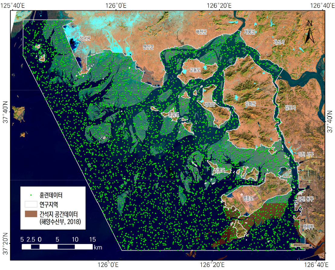
Landsat 영상 기반 수문지수의 간석지 탐지 분야 활용성 비교 - 경기만 북부를 대상으로 -
Applicability of Hydrological Indices for Tidal Flat Mapping in the Northern Gyeonggi Bay Coast
-
임종서, 김찬웅
Jongseo Yim, Chan-Woong Kim
- 이 연구는 황해안 내 경기만 북부지역의 원격탐사 기반 간석지 식별을 대상으로 수문지수의 활용성을 분석했다. 원격탐사는 조사 주기가 짧고 비용효율적이며, 접근성이 제한된 지역의 …
This study analyzed the applicability of hydrological indices for identifying tidal flats using remote sensing in the northern region of Gyeonggi Bay …
- 이 연구는 황해안 내 경기만 북부지역의 원격탐사 기반 간석지 식별을 대상으로 수문지수의 활용성을 분석했다. 원격탐사는 조사 주기가 짧고 비용효율적이며, 접근성이 제한된 지역의 현황을 파악하는 데 적합하여 현장조사의 대안으로 인식된다. 황해안은 탁도가 높아 간석지와 수면을 구별하기 어려워, 원격탐사를 통한 간석지 분류에 앞서 방법론의 신뢰도를 검토할 필요가 있다. 이 연구는 전세계적으로 폭넓게 활용하는 수문지수 기반의 간석지 분류 방법론(MNDWI, WRI, MBWI, AWEI)을 비교하고, 각 지수의 신뢰도를 정량적으로 검토하였다. 분석 결과, 이 연구가 제안한 mWRI는 다른 지수들보다 높은 신뢰도를 보였다. MBWI는 기준값에 가까운 임계치로 우수한 간석지 분류 성능을 보여, 다양한 환경에서 연구자 개입을 최소화하고 간석지를 식별하는 데 효과적일 것으로 판단된다. 원격탐사는 조사 주기가 짧고 비용효율적이며 접근성에 제약이 큰 지역의 정보를 파악하는 데 효과적이므로, 간석지의 최대 범위를 정확하게 산정하는 데 유용한 현장조사와 상호 보완적이다. 따라서 정확도가 높지만 제작주기가 상대적으로 길고 일부 지역의 자료가 부재한 정부 조사자료와 통합함으로써 그 장점을 극대화할 수 있을 것으로 기대된다.
- COLLAPSE
This study analyzed the applicability of hydrological indices for identifying tidal flats using remote sensing in the northern region of Gyeonggi Bay on the Yellow Sea coast. Remote sensing, recognized as an alternative to field surveys due to its short survey cycle and cost-effectiveness, is particularly suited for assessing areas with limited accessibility. The high turbidity of the Yellow Sea coast complicates the distinction between tidal flats and water surfaces, necessitating a review of the reliability of methodologies before classifying tidal flats through remote sensing. This research compared globally widely-used hydrological index-based tidal flat classification methodologies, and quantitatively assessed the reliability of each index. The analysis showed that mWRI, a modification of WRI, exhibited higher reliability than other indices. MBWI, with a threshold value close to the standard, demonstrated excellent tidal flat classification performance and is expected to effectively identify tidal flats with minimal researcher intervention across various environments. As remote sensing is effective in accessing restricted areas and efficient in terms of cost and time, it complements field surveys which are useful for accurately determining the maximum extent of tidal flats. Therefore, integrating it with legal survey data, which has a relatively long production cycle and lacks data in some areas, is expected to maximize its advantages.
-
Landsat 영상 기반 수문지수의 간석지 탐지 분야 활용성 비교 - 경기만 북부를 대상으로 -
-
Research Article

-
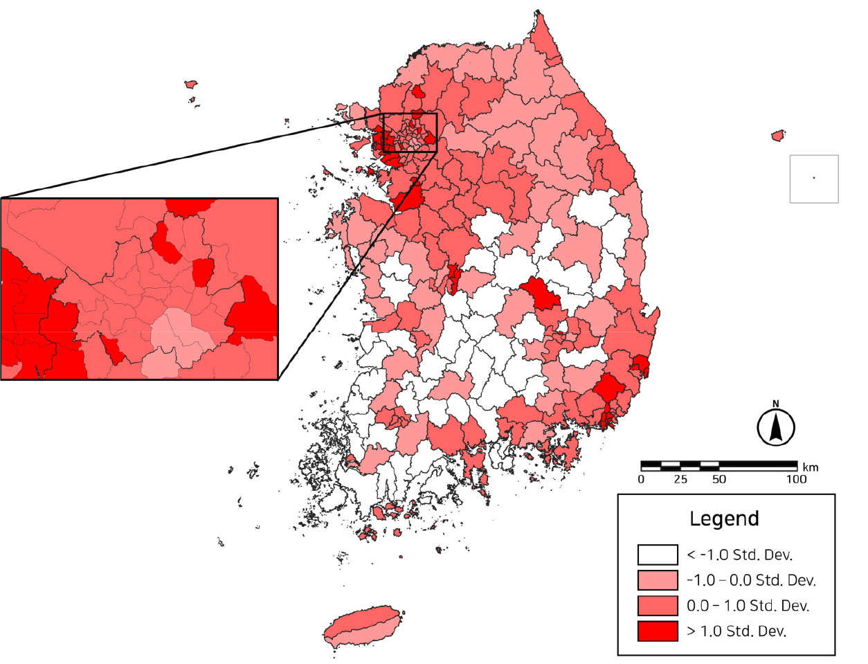
지역노동시장 특성이 청년 1인 가구 성별 분포 차이에 미치는 영향
Impact of Local Labor Market Characteristics on Gender Distribution Differences in Young Single-person Households
-
조규원
Kyu-won Jo
- 본 연구는 청년 1인 가구를 직업을 위해 이주한 집단으로 바라보고, 이들의 규모와 공간분포에서 드러나는 성별 차이에 주목한다. 청년 1인 가구 거주비율이 지역별·성별로 …
This study focuses on youngt single-person households as a group that migrates for work, and on gender differences in their size and …
- 본 연구는 청년 1인 가구를 직업을 위해 이주한 집단으로 바라보고, 이들의 규모와 공간분포에서 드러나는 성별 차이에 주목한다. 청년 1인 가구 거주비율이 지역별·성별로 차이가 있는지, 있다면 이를 해당 지역의 노동시장 특성으로 예측할 수 있는지 살펴보고자 하였다. 독립변수는 시군단위 네 개 산업의 입지계수와 도시규모로 설정하고 종속변수는 청년여성 1인 가구와 청년남성 1인 가구의 거주비율로 구분하여 두 개의 공간회귀분석 결과를 비교하였다. 분석 결과 지역노동시장 특성은 청년여성 1인 가구의 거주비율에서 더 설명력이 높았고, 유의한 관계를 가지는 변수가 두 집단 간에 차이가 있었다. 부동산업의 입지계수는 두 집단의 거주비율을 모두 높이는 효과가 있고, 전문, 과학 및 기술서비스업의 특화도는 양의 관계에 있기는 하지만 유의하지는 않았다. 반면 사업시설 관리·사업지원 및 임대서비스업과 인구 140만 이상 도시규모는 청년여성 1인 가구 거주비율에만 유의한 양의 관계를 보이고, 청년여성이 많이 종사하는 보건업 및 사회복지 서비스업의 입지계수는 청년여성 1인 가구와 유의하지는 않으나 음의 관계를 보였다. 이러한 결과 차이는 청년 내의 성별 차이를 넘어서 본인의 직업으로 독립적 생계를 유지하는 1인 가구의 특성에 기인하는 것으로 보았다. 청년여성 1인 가구가 수도권 및 광역시에서 특정 직업군에 집중되어있는 것은 안정적인 이주독립을 위한 직업과 지역의 선택권이 청년여성에게 더욱 제한적일 수 있음을 시사한다.
- COLLAPSE
This study focuses on youngt single-person households as a group that migrates for work, and on gender differences in their size and spatial distribution. The purpose of this study is to examine whether there is a difference in the residential ratio of young single-person households by region and gender, and if so, whether this can be predicted as the characteristics of the labor market in the region. The independent variables are the location coefficients of four industries and city size at the municipal level, and the dependent variable is the residence rate of young female-headed households and young male-headed households, and the results of two spatial regressions are compared. The results showed that local labor market characteristics had more explanatory power in the residence rate of young female- headed households, and the variables with significant relationships differed between the two groups. The location coefficient of the real estate industry has the effect of increasing the residence rate of both groups, and the specialization in professional, scientific, and technical services has a positive but not significant relationship. On the other hand, business facility management, business support, and rental services and city size of 1.4 million or more are only significantly positively related to the share of young women living alone, while the location coefficients of health and social services, which are dominated by young women, are negatively but not significantly related to young women living alone. This difference in results may be due to the characteristics of single-person households that are independent earners from their own jobs, beyond gender differences within young adults. The concentration of young female-headed households in certain occupational groups in metropolitan and large cities suggests that young women may have more limited options in terms of occupation and location for stable migration independence.
-
지역노동시장 특성이 청년 1인 가구 성별 분포 차이에 미치는 영향
-
Research Article

-
강원도 영동지역 봄철 대형산불의 시공간적 패턴 및 기후학적 프로세스 연구
Spatiotemporal Patterns and Climatological Processes of Large Spring Wildfire in Yeongdong, Gangwon-do, Korea
-
염나은, 김예원, 임아영, 이은걸
Naeun Yum, Yaeone Kim, Ahyeong Im, Eungul Lee
- 최근 전 세계적으로 피해가 커지고 있는 대형산불의 피해 저감을 위해서는 국지적인 지형 요인과 종관규모의 기후학적 요인을 통합한 지리학적 관점에서의 연구가 필요하다. 본 …
Large wildfires have been increasingly destructive around the world in the recent decades. To reduce the damage caused by the wildfires, it …
- 최근 전 세계적으로 피해가 커지고 있는 대형산불의 피해 저감을 위해서는 국지적인 지형 요인과 종관규모의 기후학적 요인을 통합한 지리학적 관점에서의 연구가 필요하다. 본 연구에서는 1979~2023년(45년)동안 영동지역 봄철 대형산불의 시공간적 패턴을 분석하고, 그와 관련된 기후학적 프로세스를 제시하였다. 장기간 시공간적으로 연속적인 산불위험지수와 기후재분석자료의 기후변수 간 연관성을 분석한 결과, 유라시아 중남부 지역의 기온 상승은 대기의 열적 팽창을 통해 대류권 중상층 지위고도를 상승시켜 한반도로 불어오는 북서풍을 강화함을 확인하였다. 이러한 대기의 열역학적 프로세스는 유라시아 중남부와 동아시아 북동부 지역에 중심을 두고 있는 서고동저형 기압 편차를 유도하여 북서풍을 강화시켰다. 이때 중국 동부 및 황해 중상층 대기에서 발생한 하강기류 편차가 하층의 북서풍에 합류된 후, 태백산맥을 넘으며 푄 현상으로 인해 영동지역의 고온 건조한 상태를 증폭시키는 것으로 나타났다. 이러한 기후학적 프로세스는 강원 영동지역의 산불 발화와 확산에 영향을 끼쳐 산불위험도를 증가시킬 수 있다. 본 연구는 종관기후적 특성과 함께 영동지역의 지형적 특성을 고려한 대형산불 예보 및 대응에 기여하고, 나아가 자연재해로 인한 사회경제적 비용을 절감하는 데에 활용될 것으로 기대된다.
- COLLAPSE
Large wildfires have been increasingly destructive around the world in the recent decades. To reduce the damage caused by the wildfires, it is necessary to explore the factors amplifying wildfires based on a geographical perspective with local topographical and synoptic climatological factors. In this study, we analyzed the spatiotemporal patterns of spring wildfires in the Yeongdong region over the period of 1979-2023 (45 years) and identified the integrated climatological processes associated with the wildfires. By analyzing the spatiotemporal associations between the continuous long-term Fire danger index and climatic variables from ERA5 climate reanalysis data, it was found that the increase in temperature over the south- central Eurasia enhanced the geopotential height in the mid- to upper-troposphere through the thermal expansion of the atmosphere, which resulted in the northwesterly winds blowing over the Korean Peninsula. These atmospheric thermodynamic processes induced the anomalous pressure pattern of western-High and eastern-Low, respectively, centered over south-central Eurasia and northeastern East Asia, which strengthened the northwesterly winds. At the same time, descending wind anomalies from the upper atmosphere over eastern China and the Yellow Sea have merged into the northwesterly winds in the lower atmosphere. Then, as crossed over the Taebaek Mountains, the hot and dry conditions of airflows were amplified in the Yeongdong region due to the Föhn phenomenon. These climatological processes may affect the initiation and spread of wildfires in the Yeongdong region of Gangwon Province, increasing the risk of wildfires. This study is expected to contribute to the forecasting and response to large wildfires, integrating the topography of Yeongdong region along with the synoptic climatology of Eurasia continent, which could reduce the socio-economic costs of natural disasters.
-
강원도 영동지역 봄철 대형산불의 시공간적 패턴 및 기후학적 프로세스 연구
-
Research Article
-
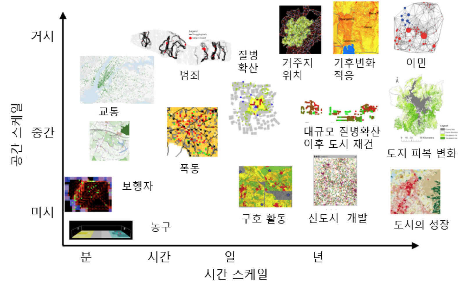
공간 시뮬레이션 모델(Geosimulation Model)과 활용 분야 - 질병 및 보건, 재해 대피, 도시 교통 -
Geosimulation Modeling and Its Applications to Public Health, Disaster Evacuation, and Urban Transportation
-
강전영, 신혜섭, 최문기
Jeon-Young Kang, Hyesop Shin, Moongi Choi
- 공간 시뮬레이션 모델은 개인 수준에서의 행동규칙, 속성, 상호작용 등을 중심으로 하여 다양한 지리적 현상(도시의 발전, 질병의 확산 등)에 대해서 이해, 해석, 예측 …
Geosimulation model has been widely used to understand and predict various geographical phenomena (i.e., urban expansion, disease spreads) through an individual-level behaviors, …
- 공간 시뮬레이션 모델은 개인 수준에서의 행동규칙, 속성, 상호작용 등을 중심으로 하여 다양한 지리적 현상(도시의 발전, 질병의 확산 등)에 대해서 이해, 해석, 예측 등을 위한 목적으로 널리 활용되어 오고 있다. 특히, 구축된 모델은 시뮬레이션을 통한 정책적 시나리오의 평가 등이 가능하다. 최근 국제 학회 및 학술지에서는 공간 시뮬레이션 모델링과 관련한 연구가 활발한 반면, 국내의 지리학계에서는 여전히 관련 연구가 미비한 것을 확인할 수 있다. 이에 본 연구에서는 공간 시뮬레이션 모델링에 대한 기본적인 내용을 설명하고, 질병 및 보건, 재해 대피, 도시 및 교통 분야로 한정하여 공간 시뮬레이션 모델링의 활용 분야에 대해 소개하고자 한다. 본 연구를 통해 학문 후속세대가 공간 시뮬레이션 모델의 기초적인 내용을 학습하고, 향후 지리학 분야에서 공간 시뮬레이션 모델을 구축 및 활용하는 후속 연구가 많이 진행되는 것을 기대한다.
- COLLAPSE
Geosimulation model has been widely used to understand and predict various geographical phenomena (i.e., urban expansion, disease spreads) through an individual-level behaviors, properties and interactions. These models not only serve as conceptual models for intellectual interactions, but they also function as simulation-based policy analysis tools, such as COVID-19 prevention tools. Despite the abundance of research and widespread application of geosimulation in recent years, few studies have been conducted in Korean geographical societies. To this end, this study introduces the fundamentals of geosimulation modeling and its applications to public health, disaster evacuation, urban planning, and transportation. We expect that this paper helps many students and early career scholars to get an improved understanding of geosimulation modeling perse, and enabling them to apply this approach for their won research.
-
공간 시뮬레이션 모델(Geosimulation Model)과 활용 분야 - 질병 및 보건, 재해 대피, 도시 교통 -

Journal Informaiton
 Journal of the Korean Geographical Society
Journal of the Korean Geographical Society


