

1. Introduction
2. Study Area
3. Concept of Fluvio-geomorphic Modifications in Response to Base Level Changes
4. Results and Discussion
1) Fluvio-geomorphic changes in different deltas along the early Holocene paleo-strandline
5. Conclusions
1) The anastomosing channels and their relation to sea level change
2) River mouth shifts along transgressive coastlines
3) Dendritic channels along paleo-coastlines
1. Introduction
Unlike the Indo-Gangetic plains, where tectonic activity plays a major role in modifying fluvio-geomorphological architecture (Pati et al., 2015, 2018, 2019; Patel et al., 2020), the deltaic geomorphology in peninsular India is controlled by climate and sea level changes (Mahalik, 2006; Dash et al., 2020). Previous studies on Indian deltas do not suggest any role of tectonic activity controlling fluvial geomorphology. The eastern continental margin has remained passive since the Quaternary; hence we rule out any major tectonic disturbances controlling the geomorphology of the coast (Mahalik, 2000; Subrahmanyam and Chand, 2006). The dominant forces controlling the geomorphology of peninsular India, especially coastal India, are fluvial, marine, and climatic.
Compared to the western coastal plain of India, the eastern coast is wider. Major rivers draining in peninsular India debouch their sediments to the Bay of Bengal, and their deltas and alluvial plains shape the fluvial geomorphology of the eastern coast of India (Dash et al., 2020). The dominant deltaic geomorphic features along the eastern coast of India are meandering-anastomosing river channels, abandoned river channels, paleo-beach ridges, paleo-swamps, and paleo-lacustrine deposits (Dash et al., 2020). These geomorphic features occur at different stratigraphic positions and thus are indicative of several episodes of geomorphic evolution of the eastern coast of India. Past studies on the deltaic plains of India have emphasized on the chronological and stratigraphical aspects of these geomorphic features. A comprehensive correlation between these features and related geomorphic phenomena is lacking.
Although sea level variations at different locations along the eastern coast of India have been marked, associated fluvio-geomorphic modifications have not been adequately explored. Based on the available reports, the Holocene sea level history along the eastern coast of India can be summarized as follows. The east coast of India experienced dynamic environmental conditions throughout the Holocene. Based on different proxy records, the relative sea level between 5 and 7 ka B.P. is estimated to be 1.2~1.5 m higher (Banerjee, 2000), and the paleo-shoreline was about 20-25 km inland from the present shoreline (Farooqui et al., 2016). Abandoned delta lobes, paleo- beach ridges, and paleochannels along the Krishna-Godavari and Mahanadi deltas suggest that the sea level rise was ~5 m around 6 ka B.P. (Nageswara Rao and Sadakata, 1993; Dash et al., 2020). Intertidal bivalves in beach ridges and estuarine sediments along the eastern coast of India, around the Godavari delta suggest a 3 m rise around 7.3 ka B.P. (Banerjee, 2000). Based on palynological evidence, Farooqui and Vaz (2000) suggested a 4.2 m sea level rise around 6 ka B.P. Following the early- to mid-Holocene sea level rise, the late-Holocene witnessed a fall in sea level. Holocene sea level changes from different proxy data are shown in Fig. 1.
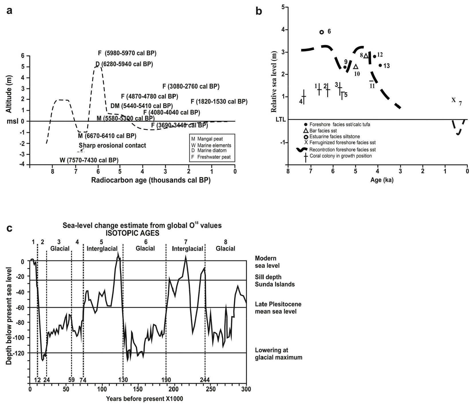
Fig. 1.
(a) Relative sea level curve along the Bay of Bengal coast of Bangladesh (Redrawn from Rashid, 2014). (b) Illustration of relative sea level change of east coast of India during Middle to Late Holocene (Redrawn from Banerjee, 2000). (c) Sea level changes during the Late Quaternary (Redrawn from White, 2011)
Using borehole logs, Mahalik (2006) illustrated several episodes of sea level change and alternation of coastal landform in the Mahanadi delta region. A previous study by Dash et al.(2020) using Optically Stimulated Luminescence (OSL) ages of paleochannel deposits suggests that the fluvial channels in the Mahanadi delta region responded to the early- to mid-Holocene sea level changes by adjusting to the base level. Strandlines along the Mahanadi delta can be distinguished by channel morphologic changes, such as anastomosing-meandering transition, dendritic channels, river mouth change, and paleo beach ridges (Dash et al., 2020). The Chilika Lagoon formed as a result of the early Holocene sea level rise, which covered a large portion of the SW Mahanadi delta (Mahalik, 2006; Dash et al., 2020). The lagoon shrank to its current extent during the mid-to-late Holocene sea level retreat.
The present study aims to provide a comprehensive review of the paleo-shoreline change along the eastern coast of India and correlate it with the fluvio-geomorphic features in the river deltas. We use satellite imagery (LANDSAT and google earth imagery) to figure out the various deltaic geomorphic features and correlate them with the Holocene Sea level change. The Holocene coastline is targeted as the paleo-geomorphic features for this period are unaltered by geological agents and are readily available for study. We also present new Ground Penetrating Radar (GPR) data along the Holocene coastline of the Mahanadi delta to figure out the depositional discontinuities in the sediment layers due to sea level change.
2. Study Area
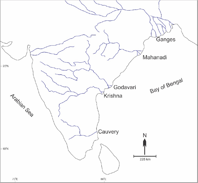
The eastern coast of India is characterized by several major river deltas. The prominent river deltas are of Krishna, Cauvery, Godavari, Mahanadi, Subarnarekha and the Ganges-Brahmaputra River systems (Fig. 2). The tectonic evolution of the eastern continental margin of India has been dealt in several studies. Early researchers studied the geologic history of major river basins in peninsular India using the sub-surface lithological data from the Oil and Natural Gas Corporation of India (Kumar, 1983; Chandra et al., 1993; Deshpande et al., 1993; Venkatarengan et al., 1993a; 1993b). Different tectonic frameworks on the evolutionary history of the eastern coast of India were postulated by later workers. A comprehensive model of the tectonic evolution of the Eastern coast of India and the episodic origin of the river basins was suggested by Lal et al.(2009). Using subsurface geophysical data (gravity and magnetic data), they suggested that the east coast of India evolved through four significant tectonic stages. The basins along the eastern continental margin of India evolved through these successive tectonic stages. The Cauvery basin developed around 52 Ma as a result of the rifting of Antarctica and development of the Natal Basin. The Krishna-Godavari basin formation was associated with the southwestward propagation of the India-western Australia rift during the Kimmeridgian-Valanginian period. The Mahanadi basin also developed during this time.
3. Concept of Fluvio-geomorphic Modifications in Response to Base Level Changes
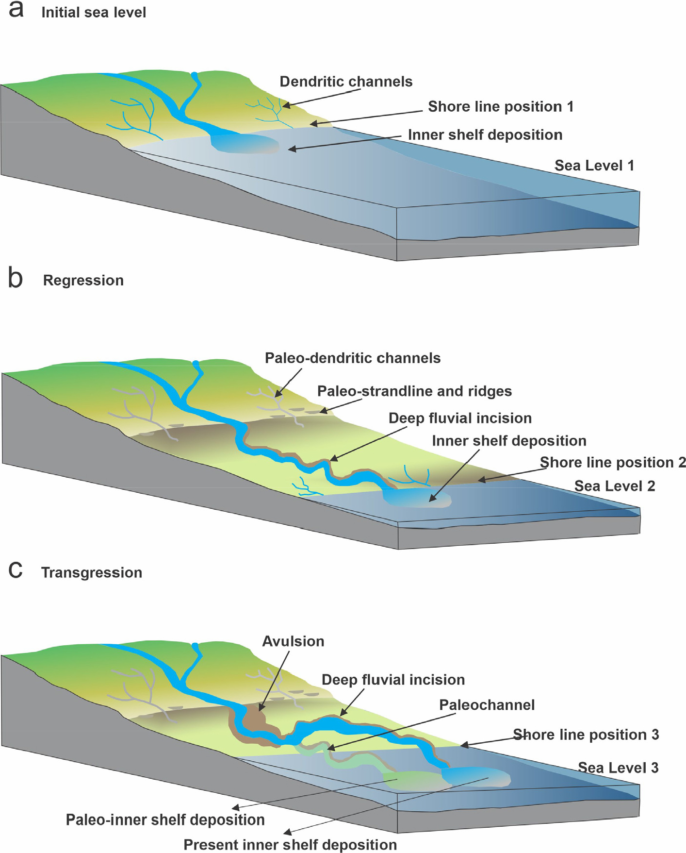
Many conceptual and experimental models were developed during the 1990’s to characterize fluvial response to upstream and downstream forcings (Penck and Brückner, 1909; Leopold and Maddock, 1953; Leopold and Bull, 1979; Butzer, 1980; Coleman, 1988; Begin et al., 1981; Begin, 1988, Schumm, 1993). At the continental margins, fluvial morphological changes are controlled by eustatic sea level changes, which is an indirect outcome of climate change. Studies around the globe have documented several fluvio-geomorphic modifications in response to base level changes, such as transformation of single-channel to anastomosing channels (David Knighton and Nanson, 1993; Tornqvist, 1993a, 1993b; Makaske, 1998, 2001), generation of dendritic drainage pattern (Ren and Shunan, 1990; Schumm, 1993; Xue, 1993) and lateral shift of river mouth at sea-land interface (Schumm, 1993; Hughes, 2012). These channel morphological changes are preserved in the sedimentary record as paleochannels, and their morphology indicates the associated environmental condition. River mouth shifts are the result of avulsion like processes nearer to the coast. A rise in relative sea level drowns the river mouth, diminishing its sediment transporting efficiency. The streams adjust to the increased sediment load through avulsion (Fig. 3a) (Ren and Shunan, 1990; Schumm, 1993; Xue, 1993). Transgressive coastlines cause river anastomosis due to aggradations at the river mouth, and these anastomosing branches coalesce to form straight/meandering channels at the lower slope when the sea level retreats (Fig. 3b) (Walker and Coleman, 1987; Makaske, 1998; McIntosh, 1983). Dendritic drainage networks form when flow concentrates near coastal areas due to lower slopes (Schumm, 1993); hence paleo-dendritic branches along different strandlines are indicative of paleo-coastline position (Fig. 3b).
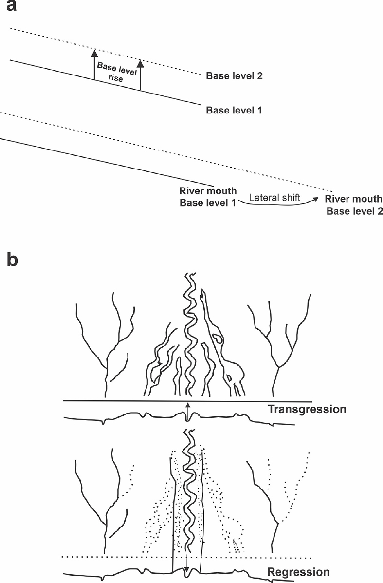
Fig. 3.
Fluvial response to base level changes along the coast. (a) When base level increases, riverbed aggrades, and the accommodation space decreases. The river mouth shifts its position to accommodate the increased sediment load. (b) Anastomosing and dendritic channels at the transgressive coastline (plan view). With regression, the anastomosing channels merge and form a single channel, and the dendritic channels become abandoned at the coast (Conceptualized after Schumm, 1993; Makaske, 1998)
Near the present-day coastline, due to the high sediment load and sea level rise, interconnected channels (possibly anastomosing channels) separated by floodplain deposits/islands are observed worldwide (Fig. 4).
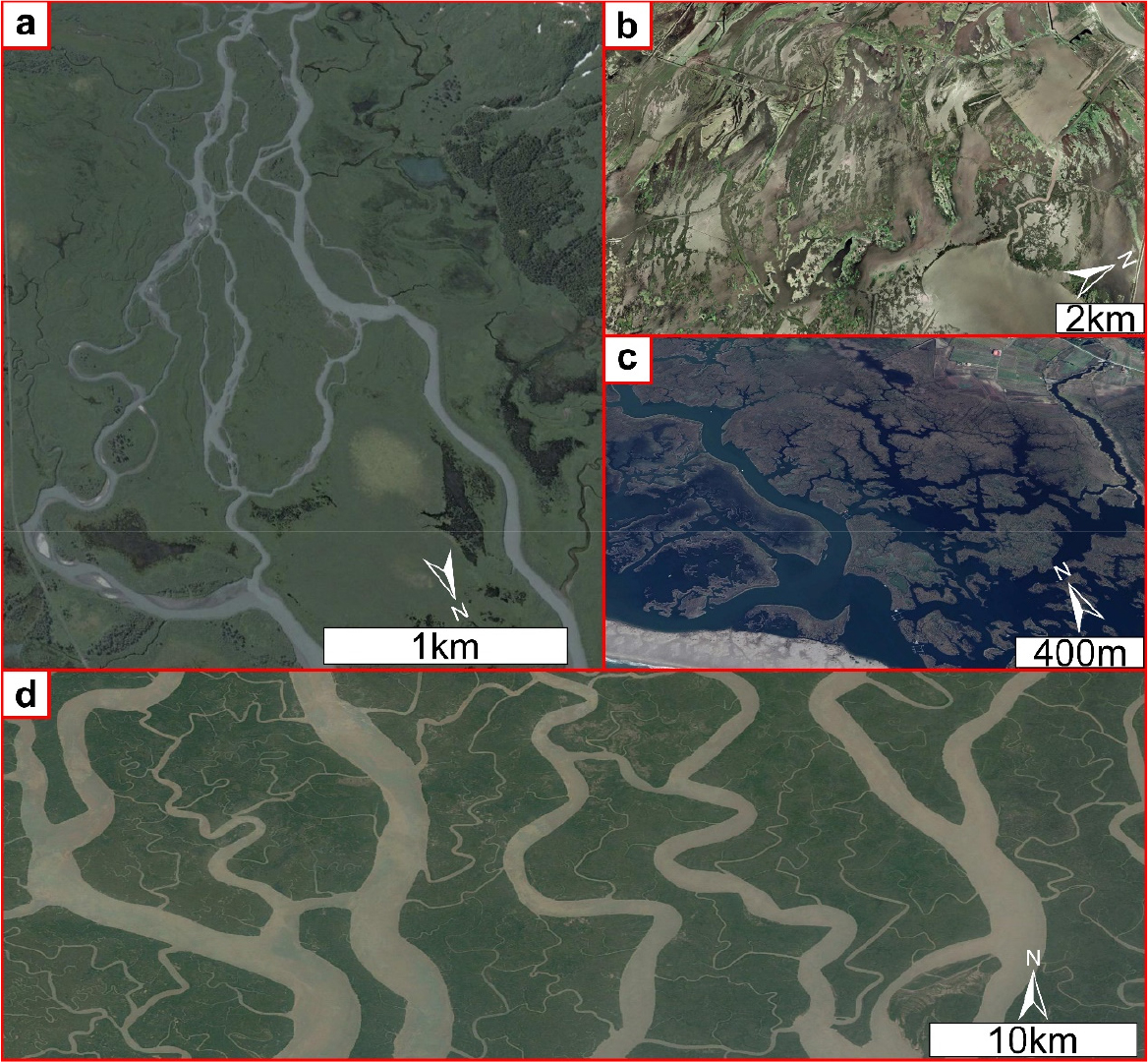
The occurrence of coastal zone dendritic channels and river mouth shifts associated with marine transgressional events are common fluvio-geomorphic features observed along major deltaic systems. Dendritic channel networks are commonly observed along tidal flats and salt marshes (Fig. 5).
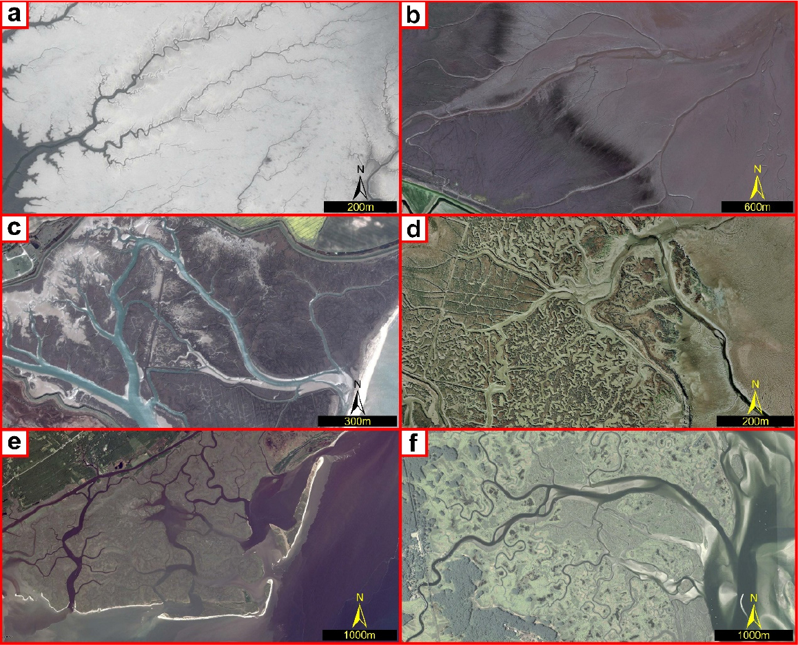
Fig. 5.
Examples of modern dendritic channels at present-day coasts (Aerial photographs from Google Earth). (a) West coast of North Korea. (b) Elongate dendritic networks reaching from the tidal flats onto the vegetated marsh, Wash (UK). (c) Highly meandering dendritic network, Norfolk (UK) (d) a complex dendritic morphology, Tollesbury Marsh (UK). (d) Interconnected meandering dendritic channels, Santee River delta. (e) Elongated dendritic channels, Essex Marsh, Massachusetts (USA)
These morphological changes near the present-day coasts are examples of fluvio-geomorphic modifications at the sea-land interaction zone. Paleochannels showing such fluvio-geomorphic features are indicative of the paleo-coastline position. With retreat in sea level, larger channels incise through the bedrock to adjust slope change. Smaller channels along the coast are either captured by large rivers or become abandoned, as they have very low incision capacity to adjust the slope change (Fig. 6) (Mixon, 1985; Colman and Mixon, 1988; Leigh and Feeney, 1995; Reineck and Singh, 2012). Thus, the chronology of paleochannels showing morphological features indicative of sea level changes is useful in deciphering the paleo-coastline position. Previous studies (Colman and Mixon, 1988; Koss et al., 1994; Leigh and Feeney, 1995; Barnhardt et al., 1997) have mentioned spatio-temporal correlation between coastal zone paleochannels and sea level changes.
4. Results and Discussion
1) Fluvio-geomorphic changes in different deltas along the early Holocene paleo-strandline
(1) Mahanadi delta
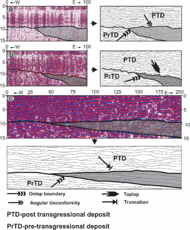
Ground Penetrating Radar (GPR) study was carried out between Early and Late Holocene strandlines in the Mahanadi delta. The detailed methodologies adapted for the Ground Penetrating Radar study are well described by Patel et al.(2020). Shallow subsurface structures were studied up to a depth of 25 meters (Fig. 7). These features are identified as onlap and downlap depositional structures in the sub-surface strata. GPR study gives evidence of the presence of paleo-coastline around Early -Mid Holocene times.
The paleo-fluvial geomorphology in the Mahanadi delta suggests sea level change played an important role in shaping the delta (Fig. 8). A detailed description of channel morphological changes along the paleo-coastlines is given by Dash et al.(2020). Several generations of paleo-stream networks in the Mahanadi delta are observed along the paleo-coastlines. These suggest episodic delta development along the paleo-strandlines. The river anastomosis is prominently observed along the transgressive strandlines. Whereas meandering channels are observed along the regressive coastlines. This suggests that the sea level rise reduced the fluvial channel accommodation space, which prompted anastomosis. During the sea level regression, the anastomosing networks coalesced, and channel progradation occurred with falling sea level.
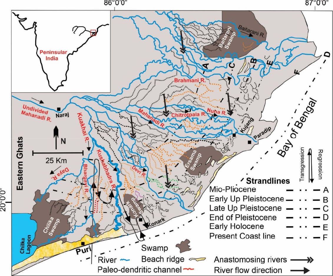
Fig. 8.
Geomorphology and drainage morphological changes in the Mahanadi delta. Spatio-temporal distribution of paleochannels in the Mahanadi delta. Note: Distributary channels are observed along the Mio-Pliocene strandline, whereas dendritic and complex network paleochannels dominate along the Pleistocene and Holocene strandlines. Anastomosing-meandering transition across the paleostrandlines of Mahanadi delta. Note: River anastomosis is observed during periods of marine transgression, which change to meandering patterns during the regressional phase
During Mio-Pliocene times, the sea transgressed farthest into the land (Fig. 9), as evidenced by radiocarbon dates of marine shells and lithological records from the Mahanadi delta (Mahalik, 2006). The inception of initial phases of the Mahanadi delta formation began at the Mio-Pliocene Sea. Rivers showing an anastomosing pattern were formed at the Mio-Pliocene transgressive boundary. Sea level retreated after the Mio-Pliocene transgression event, as represented by gravel and sand deposits of fluvial origin above Mio-Pliocene marine deposits in the Delang and Talapada boreholes (Mahalik, 2006). With the retreat in sea level, the anastomosing channels coalesced to form single meandering channels. During the Upper Pleistocene, the second phase of marine transgression occurred.
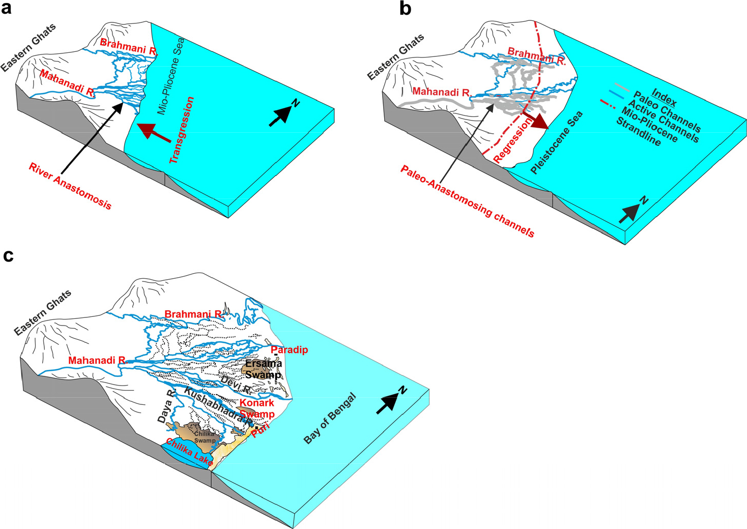
Fig. 9.
Block diagrams showing representative anastomosing Meandering transition along Mio-Pliocene strandline. (a) The Mio-Pliocene coastline was transgressive and anastomosing channels developed at the interface of sea; (b) with regression during Early to Upper Pleistocene times the anastomosing branches became abandoned, and the Mahanadi River migrated towards the Early Pleistocene coastline; (c) the present coastline position.
Towards the end of the Pleistocene, sea level retreated near the present-day coastline. The Upper Pleistocene anastomosing channels formed single meandering channels in response to the regressive event. The early to Mid-Holocene witnessed a phase of the marine high stand. Along the early to Mid-Holocene strandline major rivers of the Mahanadi delta show an anastomosing channel pattern, indicating a transgressive coastline. Tornqvist (1993b) suggests that the principal condition for the development of anastomosing channels is rapid vertical aggradation (caused by rapid sea level rise) and cohesive sub-soil, consisting of thick clay and organic matter.
All the transgressive phases along the Mahanadi delta occurred during interglacial warm climatic periods, while the regressive coastlines occurred during glacial periods. The warm interglacials could have provided enough sediments to river channels, favoring the development of an anastomosing pattern. Anastomosing channels present at Mio-Pliocene, Pleistocene, and Holocene transgressive strandlines are due to high aggradation at the river mouth and riverbank instability. Shift from anastomosing to a meandering pattern occurred in response to pronounced changes in flow velocity and sediment discharge. As base level falls, the distributaries coalesce at the lower slope and incise the bedrock. Anastomosing fluvial systems along paleo-coastlines may be more abundant than that has been reported. Major deltaic systems throughout the world show distributary channel systems along paleo-coast lines (Dash et al., 2020), suggesting that present-day distributary channels may be part of past anastomosing systems.
Dash et al.(2020) dated the coast parallel paleochannel of Kushabhadra River and inferred that the channel shift occurred around 7 ka B.P. (Fig. 10). This suggests that the channel avulsion occurred along the early-mid Holocene strandline. The paleo-swamp of the Chilika Lagoon indicates the Holocene extension of the lagoon. A similar swamp is observed at Ersama (Ersama swamp). These swamps developed due to marshy or lagoonal environments along the Holocene strandline. Dendritic channels terminate along these paleo-swamps, suggesting flow accumulation along the paleo-coastline. Meander scars are observed around the Brahmani and Baitarani rivers, and their OSL chronology dates back to early-mid Holocene times (Dash et al., 2020). These meander scars are indicative of channel shift. As the channel shifting occurred due to avulsion, the meander scars developed along the paleo-flow paths. The relict meander scars are further indicative of Holocene transgression.
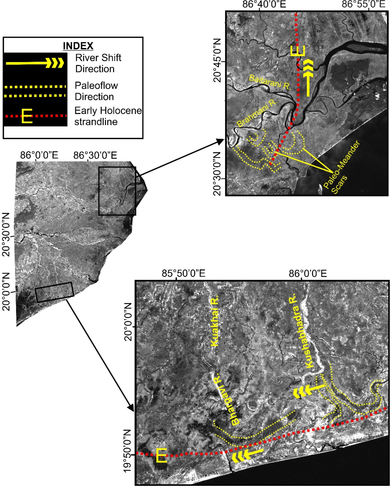
Fig. 10.
River mouth shift of Bhargavi, Kushabhadra, Brahmani, and Baitarani rivers; (a) the NW-SE flowing Bhargavi and Kushabhadra rivers shift mouth parallel to the Early Holocene strandline; (b) paleo-meander scars of EW flowing Brahmani and Baitarani rivers indicate river mouth shift along the Early Holocene strandline (Modified after Dash et al., 2020)
(2) Subarnarekha Delta
Between the macrotidal Hoogly estuary and compound deltas of the Mahanadi River, the Subarnarekha delta is situated along the Balasore coastal plain of Odisha (Fig. 11). Although there has been no systematic study on the evolution of the Subarnarekha delta, radiocarbon and Optically Stimulated Luminescence dating of the deltaic deposits by Geological Survey of India and other researchers (Niyogi, 1970; Maiti, 2013; Pattanayak et al., 2014) define the chronological evolution of the geomorphic features. Maiti (2013) combined published chronological data with cartographic mapping to study the deltaic evolution since the past 7000 years. Kamila et al.(2021) gave a detailed description of the chronological evolution of the geomorphic features and associated sea level changes. Based on these previous studies, the evolutionary history of the Subarnarekha delta can be traced back to 7 ka B.P. Around this period, the Subernarekha River along with the Rusulpur River were draining into the Bay of Bengal towards the early Holocene coastline.
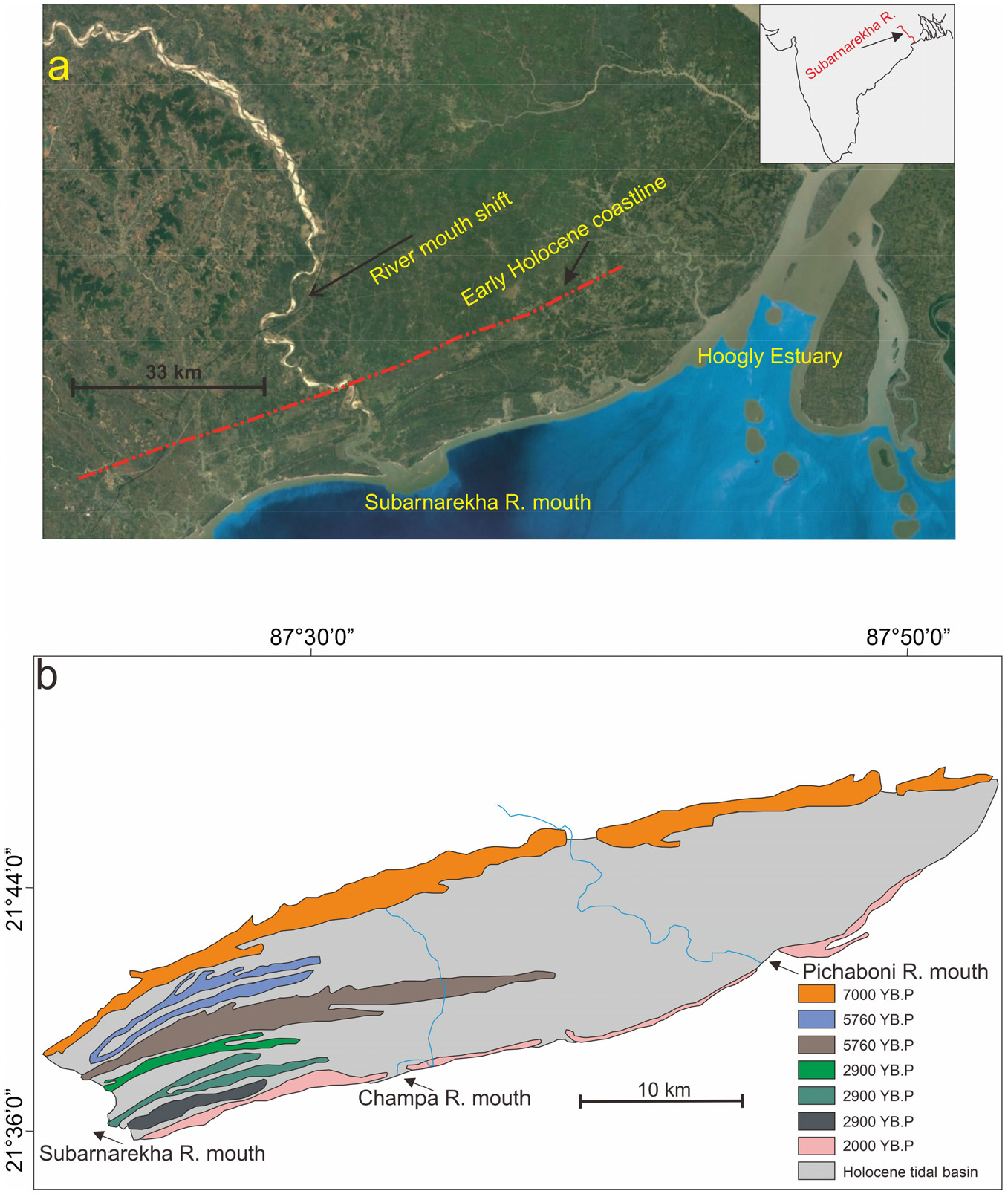
Fig. 11.
(a) Google earth image showing the Subarnarekha delta and the position of Holocene paleo strandline. Inset figure shows the location of Subarnarekha River in peninsular India. (b) The development of coast parallel beach ridges during the Holocene (modified after Kamila et al., 2021)
The longshore current drift distributed the river mouth sediments forming the beach ridges, similar to the early Holocene beach ridges observed in the Mahanadi delta plain. This deltaic environment was stable till 5 ka B.P., after which finer sediment supply from the Hoogly estuary (North of Subernarekha delta) became dominant. The previous authors describe the westward shift of the Subernarekha River mouth during this time due to local tectonics. However, Holocene tectonic movements are negligible in peninsular India, and evidence from the Mahanadi delta suggests river mouth shift due to aggradation. The delta plain has successive rows of sandy paleo-beach ridges, separated by intervening finer sediment deposits. These successive sandy paleo beach ridges are indicative of punctuations in Holocene sea level regression after the early Holocene sea level rise (Niyogi, 1970).
(3) Krishna and Godavari Delta
The geological evolution of the Krishna delta took place in five stages, continuously with falling sea levels during the Quaternary (Babu, 1973, 1975; Rao, 1985; Nageswara Rao, 1987; Krishna Rao, 1990; Rao et al., 2020). Paleo-beach ridges, swamp and tidal flat deposits mark the paleo-strandline positions (Fig. 12). The mouth shift of Krishna River is also observed near the Holocene strandline. These paleo-fluviomarine features show a parallel trend, indicating migrating shoreline. Paleo-deltaic lobes presently represented by paleochannels end abruptly along the paleo beach ridges. These distributary lobes formed as the delta debouched sediments into the Holocene sea. The oldest beach ridge dated was ~7 ka B.P. (Rao et al., 2020). This indicates that the delta prograded continuously during the Holocene.
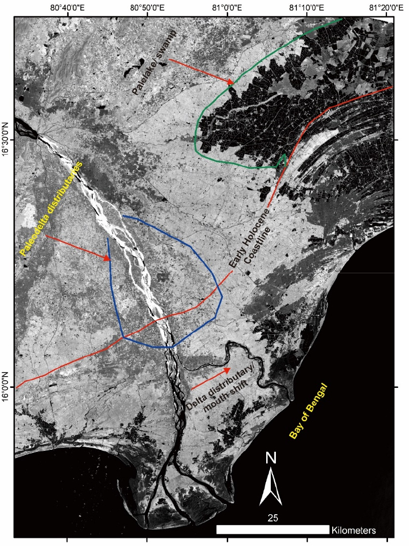
Four stages of evolution in the Godavari delta can be inferred based on previous works (Mahadevan, 1958; Babu, 1973; Rao and Vaidyanathan, 1979; Sambasiva Rao, 1979, 1987; Krishna Rao, 1990). Based on fluvial morphology and paleo-marine features, authors have classified the delta into several progradational sequences. Krishna Rao (1990) dated the four paleo-sand ridges of the Krishna delta, which are a continuation of the Godavari Delta ridges. The ages were 6500, 4500, 3250, and 2450-2150 years B.P., respectively, with the youngest towards the present-day coast. Paleo-distributaries characterize the paleo-lobes of the delta with sand at the bottom of clay deposits, which indicates that the channels were exhumed with successive phases of delta development. Based on ages and paleo-morphologic features, it can be concluded that the delta prograded throughout the Holocene towards the present coast.
5. Conclusions
1) The anastomosing channels and their relation to sea level change
Previous studies on anastomosing rivers suggest that climate change is the dominant cause for river channel instability (Mackin, 1948; Smith, 1983; Tornqvist, 1993a, 1993b; Makaske, 1998). The Quaternary sea level changes are directly related to the changes in climate (Fairbanks, 1989; Lambeck, 2001; Galbraith et al., 2002; Raper and Braithwaite, 2006; Hoegh-Guldberg and Bruno, 2010). As climate changes from drier to warmer, increased fluvial discharge causes river channel instability at the downstream, which triggers channel anastomosis (Garner, 1959; Gallais, 1967; Bowler et al., 1978; McIntosh, 1983; Bakker et al., 1989; Makaske, 1998). The river anastomosis observed along the Holocene strandline in this study suggests a rapid sea level rise during this period. As sediment discharge in peninsular India increases during the warmer climatic episodes (Dash et al., 2022a; 2022b; 2023), instability in these deltaic rivers was caused due to reduced accommodation space and increased sediment budget.
2) River mouth shifts along transgressive coastlines
River mouth shift in the alluvial environments is due to increased sediment load. These mouth-shifting events are quick and similar to avulsion-like phenomena. A fast positive swaying of sea level drowns the waterway's mouth and diminishes the stream's sediment transporting proficiency. In these conditions, the river channels adjust to the increased sediment budget by avulsion. Further, the progradation of the channels resumes at the newly developed river mouths. River mouth shift is observed in all the deltas of peninsular India. The channel shifting is observed along the lower deltaic plains, possibly due to the rapid sea level rise during the Holocene. River mouth shifts of Bhargavi, Kushabhadra, Brahmani, Baitarani, Subarnarekha and Krishna rivers along the early Holocene strandline suggest a major transgression event during this time. As sea level rise limited the accommodation space in river channels, avulsion in these deltaic rivers occurred to accommodate the increase in the sediment discharge during the warmer early Holocene period. Paleo-beach ridges have been frequently observed along the newly developed river mouths, which further suggests that the avulsion was due to sea level rise.
3) Dendritic channels along paleo-coastlines
Dendritic channels develop near the coast as the flow concentrates. These channels have low base level erosion capacity. As the sea level falls, these channels cannot incise and migrate towards the new coastline. Hence, they are either captured or become abandoned. Dendritic paleochannels in the Mahanadi delta region are indicative of paleo-coastline position. The dendritic paleochannels are not observed along the pre-Holocene strandlines of the Mahanadi delta, as these could have been altered or buried due to the later sedimentation in the upper deltaic plain.
