

1. Introduction
1) Purpose of the study
2) Methodology
2. Analysis of the Finger Plan’s Spatial Structure
1) Background of the finger plan and developmental characteristics
2) The adaptation trajectory of the finger plan
3. Case Study
1) Study of Nyhavn
2) Study of Nørrebro
3) Study of Nordhavn
4. Discussion and Conclusion
1) Discussion
2) Conclusion
1. Introduction
1) Purpose of the study
In the twenty-first century, urban planning has increasingly focused on responding to climate change, addressing the problems of overconcentration in large metropolitan areas—such as congestion and housing shortages—and seeking alternatives to urban sprawl and the decline or disappearance of non-urban regions. Establishing sustainable and resilient urban models, as well as pursuing spatially balanced regional development, are critical challenges faced by most metropolitan areas. In particular, European cities have long developed strategic plans that integrate spatial structure, transportation systems, and environmental policies to resolve the issue of urban concentration since the post–World War II period. Among these initiatives, the Finger Plan of Copenhagen is widely regarded as a representative success case of urban containment and sustainable urban development. Egnsplanved København (the Finger Plan) was formulated in 1947 by the Regional Planning Office and has since been adjusted through collaboration between the Danish Town Planning Institute and the surrounding municipalities of Copenhagen. The Finger Plan is a development model designed to curb urban sprawl by forming a linear urban structure along rail corridors while preserving the green areas between them.
In the latter half of the twentieth century, the United States and Canada codified an urban planning movement known as New Urbanism, modeled after such European cities (Charter of the New Urbanism, 1992). The United Kingdom also adopted the concept of the urban village, emphasizing not large-scale urban development plans but localized regeneration, community-centered stabilization, and cultural identity formation as core principles of urban planning rooted in traditional development approaches. New Urbanist urban management pursues multidimensional objectives such as sustainability, regional balance, transportation efficiency, social integration, and resilience. Its ultimate goal extends beyond simple physical development to the comprehensive enhancement of quality of life (Lee, 2020). The Finger Plan of Copenhagen is not merely a policy ahead of its time but a practical model that has provided strategic inspiration for urban planning capable of accommodating societal change and emerging demands. Within the historical tradition of European urban planning, Copenhagen is closely linked to the ideological foundations of urban geographical New Urbanism—namely, publicity and community, green space planning, and the integration of transportation and land use. This suggests that New Urbanism is not merely an American response model but a conceptually resilient development approach centered on community and rooted in European planning principles (Bohl, 2000; Talen, 2002). In this respect, Copenhagen’s urban planning can be regarded as a practical prototype of New Urbanism and an important case demonstrating continuity between European traditional planning and contemporary urban theory. Although the Finger Plan has been analyzed and applied in relation to radial urban structure development or policy recommendations for urban growth, no research has yet addressed qualitative social and community transformation from a geographical perspective.
This study reviews the planning background and process of the Finger Plan, analyzes its characteristics across different historical phases, and diagnoses the development of local communities and their social resilience. Particular attention is given to the conceptual similarity between the Finger Plan and the New Urbanist movement that developed in the United States in the latter half of the twentieth century. The analysis focuses on how the Finger Plan influenced the key objectives of urban improvement advocated by New Urbanism, self-sufficient communities, transit-oriented development, walkable urban structures, and mixed-use development (Calthorpe, 1993; Duany et al., 2000). Several case areas where the Finger Plan has been implemented are examined in detail to identify lessons for community-based cultural development. By drawing on the ideas of the Finger Plan, the study aims to address solutions to regional imbalance resulting from metropolitan expansion, establish a foundation for resilient recovery and sustainable principles, improve spatial efficiency, and strengthen citizen participation-based planning.
2) Methodology
This study adopts a qualitative case study approach. The analysis is primarily based on secondary sources, drawing on reliable academic literature, government reports, and urban planning guidelines as core references. Reports published by the Regional Planning Office and the Danish Town Planning Institute, as well as archival publications provided by the City of Copenhagen, were utilized to examine the historical background, revision cycles, and key characteristics of the Finger Plan (City of Copenhagen, 2020; 2023). In addition, urban indicators and evaluation data released by international organizations such as UN-Habitat and the OECD, along with relevant policy reports and academic studies, were used to assess the policy outcomes of the Finger Plan(OECD, 2017; Statistics Denmark, 2023).
To investigate whether the Finger Plan can serve as a model for the community-oriented urban environment and sustainable development advocated by the New Urbanism movement, representative areas where the plan has contributed to local community improvement, such as Nyhavn, Nørrebro, and Nordhavn, were selected for case analysis. Fieldwork was conducted in these three areas to verify specific aspects of the planning process and evaluate its practical impact. Five criteria were established for the comparison of the three towns: (1) effectiveness of urban containment strategies; (2) contribution to urban stability through transportation system integration and public transit connectivity; (3) performance in housing and social integration policies; (4) levels of citizen participation and governance structuring; and (5) flexibility and resilience in responding to social change, including sustainability and climate adaptation. Through case comparison, the study identifies planning characteristics shaped by the institutional and cultural contexts of each city, discusses common achievements and policy potential related to community resilience and sustainability, and explores implications for urban planning in South Korea.
2. Analysis of the Finger Plan’s Spatial Structure
1) Background of the finger plan and developmental characteristics
Copenhagen’s Finger Plan is a strategic model for urban and regional development announced in 1947. It was proposed by Peter Bredsdorff and Steen Eiler Rasmussen of the Danish Town Planning Institute in response to rapid urbanization and severe housing shortages caused by population concentration in cities after World War II. Although it held no legal status at the time of its publication, the plan provided a foundational design framework for preventing disorderly urban expansion and guiding the systematic and stable growth of urban spatial structure (Ministry of the Environment, DK, 2015). It has also been evaluated as having been influenced by the British New Town movement and Lewis Mumford’s theory of regionalist urban planning (Knowles, 2012).
The Finger Plan focused on preventing urban sprawl by directing urban expansion along a railway-based radial structure while preserving the green spaces in between. The core of Copenhagen was conceptualized as the “palm,” from which five “fingers”—linear development corridors connected by the rail system and radial road networks—extended outward. Green wedges were inserted between these fingers to be preserved as recreational and agricultural areas where urban development was prohibited. This structure facilitated residents’ access both to green spaces and to the city center of Copenhagen (Figure 1).
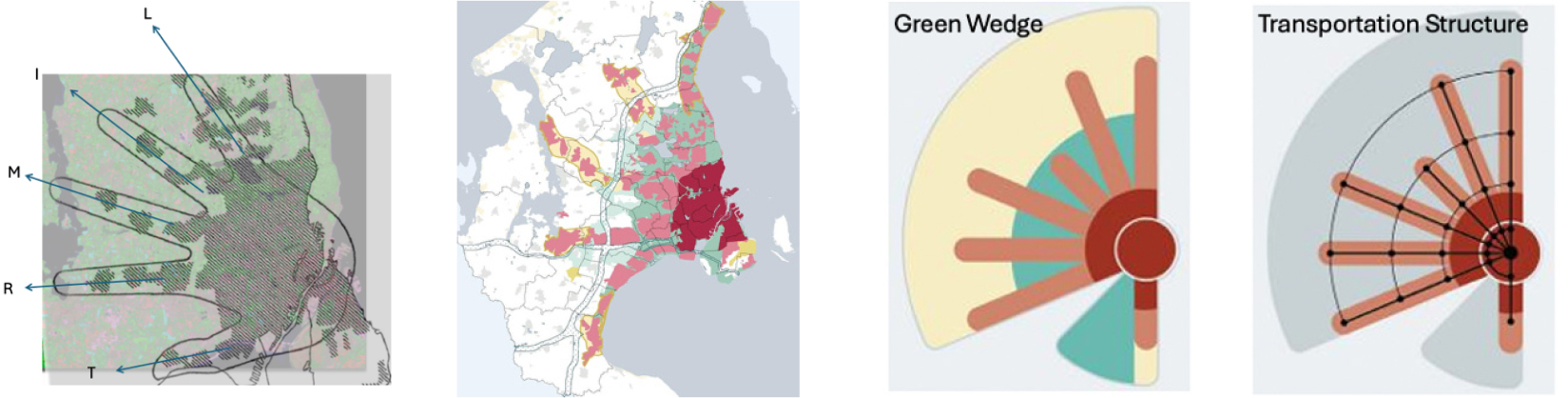
Under this plan, the Copenhagen metropolitan region was spatially divided into four zones: the central urban core (the palm), urban expansion corridors (the fingers), green belts, and the outer periphery of Greater Copenhagen. The primary objective of the Finger Plan was to promote sustainable growth and the efficient use of public transportation while maintaining a balance between urban development, infrastructure expansion, and environmental conservation.
The L (Little Finger) represents one of the high-income residential areas located along Copenhagen’s northern coastline, encompassing communities such as Klampenborg, Rungsted, and Birkerød that anchor the focal city of Hellerup. Also referred to as the ‘Whiskey Belt,’ this area is characterized by large detached houses with private gardens. Over time, it has evolved into a district accommodating apartments for affluent young residents, supported by continuous improvements in transportation infrastructure, green space preservation, and the development of waterfront commercial facilities. The R (Ring Finger) corridor comprises middle-class communities in the northwestern region, including Gladsaxe, Bagsværd, Værløse, and Farum, with a substantial proportion of single-family homes, some of which are high-end dwellings. Residential development has steadily progressed in accordance with the expansion of transportation infrastructure. The M (Middle Finger) refers to a mixed area of industry and middle-class housing located on the northwestern outskirts, including major urban centers such as Herlev, Ballerup, and Egedal, and some districts have undergone redevelopment in response to industrial restructuring, accompanied by improved transport accessibility. The I (Index Finger) axis extends toward the western region and consists largely of public housing areas with high proportions of immigrants and low-income populations. Communities such as Albertslund, Brøndby, and Taastrup are located within this zone, where various policies promoting social integration and urban regeneration have been implemented, and certain areas have been designated for redevelopment. The T (Thumb Finger) corridor stretches along the southwestern coastline and is primarily composed of high-density residential districts dominated by middle-income households. Communities such as Hvidovre, Ishøj, Greve, and Køge fall within this area. Like the western corridor, this region also has a relatively high share of immigrants and has been designated as a major redevelopment zone, leading to the expansion of transportation infrastructure along the coast.
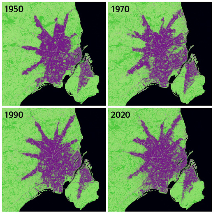
The five development corridors began to take shape around major railway nodes in the 1950s. In 1973, the City of Copenhagen granted legal authority to the principles of the Finger Plan, enabling national planning guidelines under the Danish Planning Act to regulate urban development. During this period, the existing railway network was expanded into the S-train system, accompanied by plans for large-scale park-and-ride facilities and ring roads. Although rapid urbanization in Copenhagen could have resulted in uncontrolled expansion into the hinterlands, the railway-centered planning approach helped establish major population flows from the periphery to the urban core, thereby inducing concentrated growth in these suburban towns. As population growth in the city center slowed and suburban areas began to outpace the core in growth rate, the suburban districts experienced qualitative improvements in urban services and more dynamic intra-regional interactions. As development strategies aligned with the characteristics of each corridor were consolidated, the economic and cultural potential of the metropolitan region reshaped population distribution trends, generating a new urban development cycle centered on the core area. The Finger Plan of Copenhagen thus became the foundation for a long-term urban planning strategy, guiding the city through phases of metropolitan expansion and planned suburbanization while continuously adapting to new urban conditions up to the present day (Table 1, Figure 2).
표 1.
Phase-specific characteristics of the finger plan
The continual incorporation of the Finger Plan into public policy and its periodic revisions in response to changing urban conditions have successfully curbed disorderly urban sprawl while maximizing accessibility to public transport through the coordinated development of rail systems and road networks. This approach facilitated the redistribution of population and employment, contributing significantly to balanced growth across the entire metropolitan region. By reducing traffic congestion and establishing a sustainable mobility system, it also laid the foundation for subsequent climate change mitigation strategies.
In particular, the spatial planning framework centered on green space preservation (as seen the Figure 2) functioned as a key mechanism for containing metropolitan expansion. Beyond acting as a physical growth boundary, it provided residents with easily accessible recreational areas, thereby enhancing overall quality of life while mitigating noise and pollution to maintain a pleasant urban environment. The conservation of natural landscapes and ecosystems within these green zones has supported biodiversity and environmental sustainability. Moreover, by serving as designated sites for climate adaptation infrastructure, these areas have strengthened the city's resilience to climate change.
Under the Danish Planning Act, the Finger Plan became the principal framework through which individual municipalities structured their development strategies, thus reinforcing inter-municipal cooperation and promoting a harmonious regional urban structure under a unified national planning vision. Although the curbing urban sprawl strategy based on green space configuration may appear similar to the containment concept of the Greenbelt, it is more accurately characterized as a flexible and adaptive ‘Green Structure’ (Lee, 2019). Rather than enforcing rigid exclusion, it embodies a forward-looking model of ‘resilience’ and ‘sustainable development’, providing a concrete alternative capable of responding dynamically to evolving socio-environmental challenges.
2) The adaptation trajectory of the finger plan
The Finger Plan was applied to the systematic growth of the Copenhagen metropolitan region in the late twentieth century, leading to the development of the Ørestad district, which had not been included in the initial plan. By designating the island of Amager as a new development axis, a new metro line was constructed, and high-density development was pursued alongside infrastructure improvements. At the time the original Finger Plan was proposed, Ørestad—located on Amager Island—consisted largely of wetlands and pastures designated as nature conservation areas, and it was excluded from the S-train network. Due to its geographical characteristics, including its remote location from the city center and its lack of road and public transport infrastructure, the area was dismissed as having little development value and regarded as incompatible with the rail-oriented development philosophy. Parts of Amager were additionally designated as military training zones and environmentally protected areas, further constraining urban expansion.
However, Ørestad, on the western side of Amager Island, held strategic potential as it lay midway between central Copenhagen and the airport, and the construction of the Øresund Bridge enabled integration with Malmö, Sweden. This provided the opportunity to position the area as a hub for international economic and human exchange. In 1993, the Ørestad Development Corporation was established, and a Transit-Oriented Development (TOD) structure was implemented through the construction of the metro line. The metro network was designed to connect with the existing S-train system, creating an urban structure in which public transit was accessible within a five-minute walking distance. This modernized the rail-centered urban expansion philosophy. Land use planning adopted a mixed-use model accommodating residential, commercial, educational, and public facilities alongside high-density, high-rise buildings. Upholding the Finger Plan principle of development predicated on green space preservation, Ørestad integrated parks, ecological corridors, and waterways into its spatial design, becoming a 21st-century extension of the Finger Plan. Recognized as an evolutionary finger, the ‘sixth finger’ or an ‘extension of the thumb’, it has become a prototypical model of contemporary urban planning.
The development of Ørestad catalyzed the interconnection of suburban nodes, transforming previously fragmented settlements stretching from the inner city toward the periphery into a continuous linear formation. Nevertheless, the preservation of green wedges between the fingers remains non-negotiable, ensuring ongoing control over the outward expansion of urban boundaries. In 2007, the Danish Ministry of the Environment formally adopted the principles of the Finger Plan as official planning guidelines. With climate-responsive urban development, high-efficiency energy use, and multifunctional mixed-use spatial design as its core modules, Finger Plan 2.0 was proposed in 2020. In response to emerging challenges such as climate change, biodiversity loss, and social inequality, the renewed strategy places urban regeneration at its center. Enhancements to green infrastructure, the promotion of cultural diversity within communities, the conservation of traditional landscapes, and the establishment of 15-minute city-based local living environments serve as the principal framework through which the Finger Plan continues to be revised and advanced (Table 2).
As shown in Table 2, the initial role of the Finger Plan centered on managing suburban expansion in the metropolitan area, developing growth corridors, and coordinating land use (Finger Plan Secretariat, 1947). These processes were driven by the Regional Planning Office, which functioned as a mediating and technical support body between national planning authorities and local governments. During this phase, metropolitan cooperation mechanisms between the City of Copenhagen and surrounding municipalities coordinated the allocation of housing, industry, and transport infrastructure, while buffer zones were designated to clearly demarcate green belts and development-restricted areas.
표 2.
Key developmental contents of the finger plan
Source: The Danish Nature Agency, 2015, The Finger Plan: a Strategy for the Development of the Greater Copenhagen Area, Ministry of the Environment, Denmark. (www.naturstyrelsen.dk); City of Copenhagen, 2020, Copenhagen Climate Plan 2025, City of Copenhagen Technical and Environmental Administration, Copenhagen, Denmark.
Following administrative restructuring in the mid-1970s, the authority of the Regional Planning Office was either strengthened or decentralized. Under the municipal reform, certain functions were transferred to the Hovedstadsrådet(Greater Copenhagen Council), and in 1990, regional planning responsibilities were reorganized under district-level planning committees and the National Spatial Agency. After the 2007 administrative reform, metropolitan planning in Greater Copenhagen became divided between the Danish Nature Agency and Region Hovedstaden (representing the core city and the metropolitan authority). Despite the institutional restructuring, the fundamental principles of the Finger Plan, which concentrated development along transport corridors and strict preservation of the green wedges, have remained intact.
At present, regional development (regionplanlægning) is operated in the form of a national-level strategic framework through the National Planning Directive for Greater Copenhagen. The functions previously held by the Regional Planning Office have been dispersed across three main entities: the Danish Nature Agency (Naturstyrelsen), Region Hovedstaden (Capital Region Authority), and the Local Planning Offices of individual municipalities. Naturstyrelsen is responsible for the legal stewardship of the Finger Plan, designating developable and conservation areas and regulating land use based on rail and metropolitan transport corridors. Region Hovedstaden coordinates planning across 29 municipalities, including the City of Copenhagen. At the same time, local planning offices formulate detailed land-use plans (local plans) in alignment with national and regional directives, managing major urban regeneration and new town development projects such as Ørestad, Nordhavn, and Carlsberg Byen. This study interprets the Finger Plan not merely as a metropolitan-scale spatial framework but as a multi-scalar connective system that extends from the plan to the corridor, the station area, and finally to the pedestrian route. From this perspective, the Finger Plan is understood to have generated and institutionalized design-oriented interventions at the local scale, such as the configuration of station plazas, mixed-use block guidelines, parking regulations, and pedestrian–bicycle network design, through its integration with the physical infrastructure of the rail corridors. For instance, the station-area master plans of Ørestad and Nordhavn explicitly articulate the Finger Plan’s corridor-based logic by regulating local plans within a walkable catchment (typically 400–800 meters from the station), specifying high floor-area ratios, mixed land uses, and a modal shift toward low-car, high-bicycle mobility (Knowles, 2012). Consequently, the Finger Plan should be interpreted as exerting a two-tiered influence: determining “where” growth is permitted at the metropolitan scale, and guiding “how” that growth is spatially and functionally designed at the district scale.
3. Case Study
Since 2020, the evolution of the Finger Plan into Finger Plan 2.0 has shifted its primary objectives toward a carbon-neutral urban model centered on climate- responsive coastal management, coastal restoration, and disaster prevention. With the addition of a new spatial coastal regeneration axis to the existing finger structure, the original strategies of transport corridor development and green preservation have been expanded to incorporate waterfront resilience, flood-adaptive public spaces, and CO₂-neutral urban development. As a result, what began as a transport-oriented scheme has evolved into a comprehensive climate crisis response strategy.
Copenhagen’s Finger Plan 2.0 has thus transitioned from a mere urban containment model to a paradigm of Resilient Coastal Urbanism (Dupuy, 2008). By integrating a coastal development axis (often referred to as the ‘Blue Finger’) into the traditional land-based growth corridors, the model now encompasses disaster mitigation, residential development, commerce, and ecological restoration within a unified urban growth framework. To further elucidate the trajectory of this evolution, three contrasting towns were selected for comparative analysis between the outcomes of Finger Plan 1.0 and the strategies of Finger Plan 2.0.
1) Study of Nyhavn
Nyhavn is a historic harbor located along the main canal in central Copenhagen. The term havn means ‘port’ in Danish. Established in the 17th century as a maritime infrastructure for shipbuilding and cargo transport, it eventually lost its industrial function through post- industrial decline. Classified within the Palm area of the Finger Plan structure, it is spatially connected to key civic and cultural landmarks such as Amalienborg Palace, the Opera House, and major financial institutions via the central pedestrian axis Strøget.
Rather than allowing the area to fall into decay, the principles of open space retention embedded in the Finger Plan guided the transformation of the port’s waterfront into a pedestrian-oriented promenade (Figure 3). Through the restoration of traditional Danish architectural elements and the implementation of coastal regeneration policies, the former industrial harbor was redeveloped into a vibrant waterfront district anchored in tourism, commerce, and culture. Although not a direct application of the Finger Plan in institutional terms, Nyhavn exemplifies the urbanism paradigm of European city centers where economic vitality and public accessibility are simultaneously restored (Hall, 2002; Talen, 2002). Alongside harbor revitalization, Denmark’s first department store and adjacent commercial areas regained economic dynamism, reinforcing both heritage conservation and civic openness at the core. As tourism and service industries expanded, Nyhavn emerged as a central case of urban redevelopment that contributed to strengthening Copenhagen’s international economic competitiveness (Table 3).
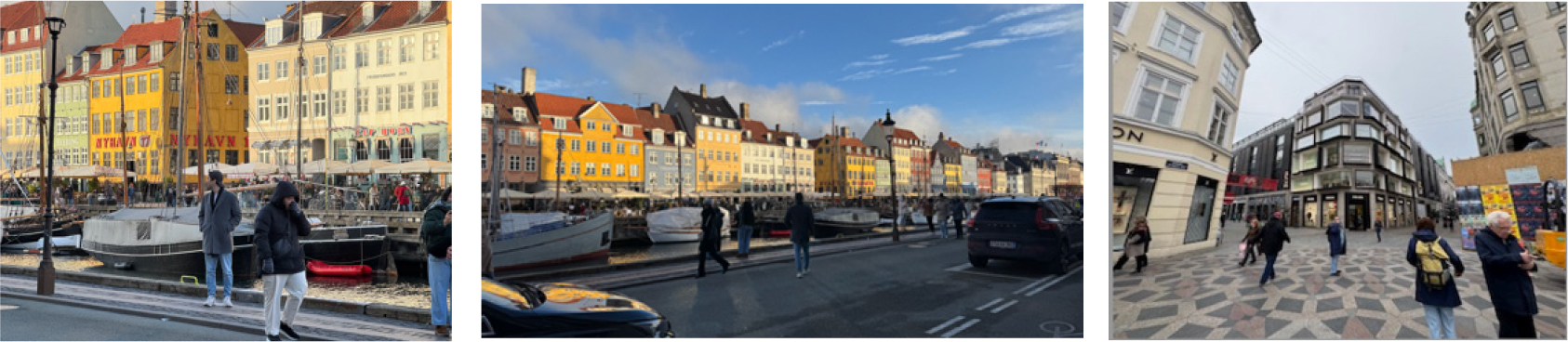
표 3.
Comparison of performance indices between Nyhavn and Nørrebro
Source: City Population, 2025, Nørrebro population statistics;City of Copenhagen, 2023, Population and income statistics by district;SPUR., 2022, Housing for Everyone, the Danish Way.;European Environment Agency (EEA), 2022, Urban green space indicators.
Unlike the rail-based growth model of the original Finger Plan, Nyhavn pursued a core stabilization strategy by transforming a declining inner-city port site into a pedestrian- and bicycle-priority public promenade, regenerating it into a tourism-, commerce-, and culture-oriented mixed-use district. This approach stood in contrast to the early outward expansion framework of the Finger Plan. Between the 1960s and 1980s, heritage protection ordinances were introduced to prevent functional decline and neglect, accompanied by civic movements advocating for landscape preservation. In the 1990s, a comprehensive harbour regeneration masterplan was established, and under the Copenhagen Harbour Transformation Policy, a pedestrian-oriented waterfront was developed.
By the 2000s, the area experienced a surge in commercial activity—particularly restaurants, hotels, and financial services—yielding substantial economic outcomes. With over 10 million annual visitors, Nyhavn has become Copenhagen’s most frequented tourist destination. More than 80% of its buildings now operate as commercial or food service establishments, underpinning its role as an economic hub. Notably, 49% of trips made by residents are by bicycle and 27% by walking, demonstrating the success of the car-free waterfront strategy. The regeneration also contributed to improvements in public safety, with incidents of violence and theft decreasing by 15% between 2015 and 2020 (Danish Police Open Data). Property values in adjacent areas rose accordingly, with land costs increasing by 30% after 2010. Today, the City & Port Development Corporation continues to coordinate public–private governance strategies to sustain and expand this regeneration model.
The development characteristics of this area can be briefly summarized as follows, urban vitality, public realm as a civic spine based on the principles of the New Urbanism movement. The principles of New Urbanism can be summarized as follows: Neighborhoods should be compact, pedestrian-friendly, and mixed-use, with a strong emphasis on the public realm. Its core themes can be described as human-scaled urbanism, street vitality, and the integration of work–live–leisure functions. In particular, the spatial characteristics are emphasized as follows: Located at the historic waterfront, Nyhavn represents a fine-grained, pre-industrial urban form, narrow plots, continuous façades, and high building permeability. Streets are hierarchically organized around a public waterfront axis, promoting visual and physical continuity between the built form and the harbor. Public spaces (e.g., waterfront promenade, pocket plazas) are scaled for pedestrians rather than automobiles. Nyhavn embodies many New Urbanist ideals long before the movement’s formalization, mixed-use ground floors, small block patterns, and a lively, walkable street edge. The reactivation of Nyhavn’s waterfront in the 1990s mirrored New Urbanist placemaking principles, prioritizing public life (Gehl, 2010) and the reinvention of post-industrial areas for civic engagement. In other words, it indicates that social integration has been achieved. This can also be confirmed through quantitative indicators. Pedestrian flow increased by 120% between 2000–2020 (City of Copenhagen, 2020), and 65% of ground-floor units serve public-facing uses (cafés, restaurants, cultural venues). To interpret, Nyhavn serves as a historic prototype of New Urbanist “human-scale urbanity”, an early European manifestation of the movement’s civic-space ethos, later influencing Copenhagen’s broader urban design paradigm.
2) Study of Nørrebro
Nørrebro is located northwest of central Copenhagen and has a population of approximately 80,000 as of 2025. Characterized by a high proportion of immigrants and multicultural residents, the area also has a substantial share of social housing. Geographically situated between the Core zone and the western Frederikssund rail corridor, it represents one of the development axes within the Index Finger of the Finger Plan. Since the end of World War II, Nørrebro has been a neighborhood with a distinctly high concentration of low-income immigrant households, a socio-cultural feature that remains evident today. Historically dominated by small-scale manufacturing and substandard housing, the area was highly vulnerable to industrial restructuring and consequently experienced a significant decline.
With the introduction of the Finger Plan, principles of transit-based densification were applied along existing industrial rail infrastructure, promoting mixed-use residential and commercial development. Although green space provision was relatively limited due to the prevalence of industrial land uses, vacant factory plots were converted into community centers and sports grounds to serve residents. As shown in Table 3, the establishment of the Nørrebro Route, a strengthened bicycle network, resulted in Nørrebro achieving the highest cycling modal share in Copenhagen. Nyhavn and Nørrebro are development areas established under the framework of the Finger Plan 1.0. Nyhavn, located in the urban core during the industrial era, served as a central hub of industrial and commercial activity, but it later faced a period of urban decline and depopulation during the post-industrial transition. In contrast, Nørrebro—densely populated by immigrants and manufacturing workers—became a so-called “shock city,” suffering from economic stagnation and social marginalization, and was neglected for some time. With the implementation of the Finger Plan 1.0, the trajectories of these two districts present a striking contrast, offering valuable insights into the diverse outcomes and implications of urban development strategies within the same metropolitan framework.
The district had a high proportion of low-income households and a significant presence of immigrants from Pakistan and the Middle East, making it a multicultural area where latent social conflicts were embedded. Former working-class housing blocks were repurposed into public schools, while industrial sites were converted into public spaces, providing facilities such as skateboarding areas and community centers for residents’ use (Figure 4). It represents the most successful implementation of the Finger Plan’s principles of high density, public transportation integration, and bicycle-oriented planning. Through the construction of social housing, residential conditions were improved, and redevelopment, along with public investment, stimulated employment, ultimately achieving urban social integration. As the district with the highest population density and the highest bicycle usage rate in Copenhagen, it has become a model of Compact & Transit-Oriented Urbanism.
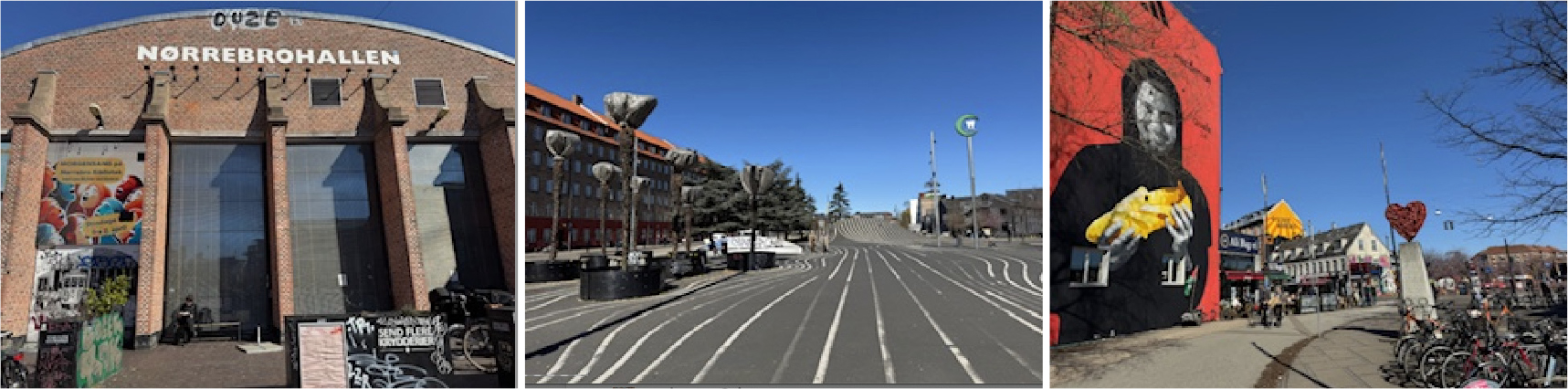
Nørrebro's development is summarized as Social Diversity, Density, and Everyday Urbanism. This aligns with the New Urbanism principle: “Cities should contain a diversity of housing types, people, and activities, integrated within walkable neighborhoods.” Specifically, inclusivity, density, and a fine-grained social structure are key themes. In terms of social context, Nørrebro is an inner-city, high-density neighborhood (approximately 21,000 residents/km2) with mixed ethnic and socio- economic composition. The area retains a traditional urban grid, narrow streets, and strong local street economies. Active mobility dominates, with 53% of all trips made by bicycle or on foot (City of Copenhagen, 2020; 2023). Comparing this area's development with the New Urbanism movement, the social mix as spatial structure stands out. Nørrebro's dense, mixed-tenure fabric exemplifies New Urbanism's diversity principle, combining social housing, private dwellings, and creative industries within a walkable radius. Block-scale public life was achieved through the redesign of Superkilen Park, which introduced a public realm-driven regeneration that exemplifies community-based design, aligning with the New Urbanist emphasis on public participation and cultural inclusivity. Quantitative indicators of development performance include improved green space accessibility from 4 m2/person (2005) to 10 m2/person (2020), and a cycling mode share of 53% (vs. the city average of 45%). As a result of the mixed-use development, the land use ratio of residential, retail, and cultural lands is 0.79, demonstrating a high level of land-use diversity. In other words, Nørrebro illustrates how social equity and neighborhood diversity, central tenets of New Urbanism, can be realized within dense, historic urban fabrics not through new construction, but adaptive and participatory design processes.
3) Study of Nordhavn
Nordhavn is a waterfront redevelopment area located northeast of central Copenhagen. Under Finger Plan 2.0, it is recognized as the ‘sixth finger’ or an example of a ‘maritime extension of the finger structure.’ The urban development vision for Nordhavn can be summarized in five core strategies.
First, following the climate-responsive principles of Finger Plan 2.0, Nordhavn declared its ambition to become a 100% CO₂-neutral district, positioning itself as a testbed for carbon-neutral urbanism. It aims to establish a community powered by renewable energy while prioritizing the qualitative conservation of the coastal environment. Second, it constitutes a TOD development with the opening of Metro Line M4, which connects the district to the city center within seven minutes. Third, 40% of the total land area is allocated to residential use, another 40% to commercial functions, and 20% to public facilities, thereby realizing high-density mixed-use development. Fourth, waterfront accessibility is maximized, with 80% of all residents living within 300 meters of the shoreline. This strategy not only provides the sea as a recreational amenity for local inhabitants but also establishes a framework for preventing marine pollution and preserving the coastal ecosystem. Finally, the share of private car use is restricted to below 25%, while walking and cycling infrastructure are prioritized to create an environmentally friendly community (Fig. 5). The outcomes of these strategies are presented in Table 4 below.
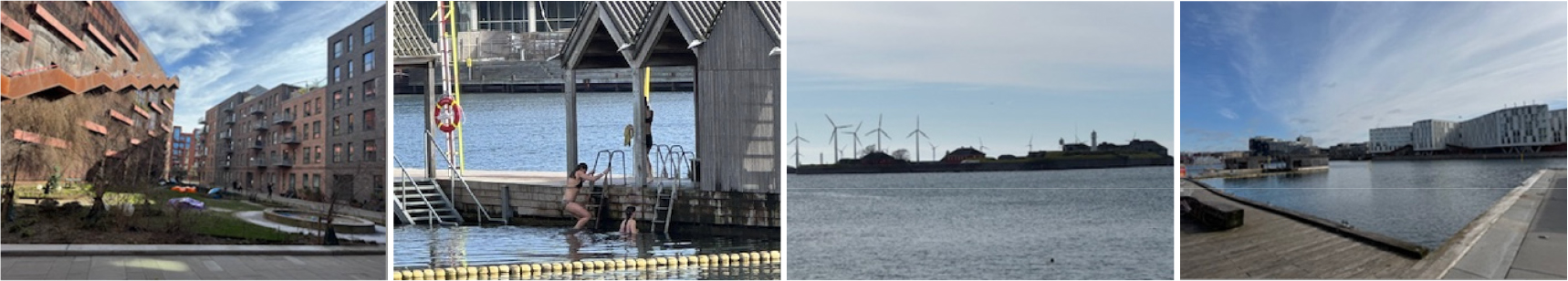
표 4.
Growth performance
Source: same as Table 3.
Whereas the earlier stages of development were driven by railway infrastructure, the recent phase has been characterized by metro connectivity and bicycle-based mobility. The original principle of securing green corridors has been reinterpreted through guaranteed public accessibility to the waterfront. This represents the realization of a blue economy in which living and working environments are in balanced coexistence. Moreover, through infill urbanism, it has served as an effective instrument for curbing urban sprawl.
It has been widely recognized as Copenhagen’s flagship climate-adaptive waterfront project and is now considered a model for eco-friendly new towns rooted in port regeneration. In anticipation of sea-level rise, elevated ground has been constructed, while generous public waterfront spaces have been secured, amounting to an extension of the Blue Finger concept (Figure 6). Furthermore, to prevent inundation caused by heavy rainfall and rising sea levels, flood canals and retention basins have been embedded throughout the community. These facilities function as public parks under normal conditions but serve as water storage infrastructure during extreme weather events, forming a resilient grid system.
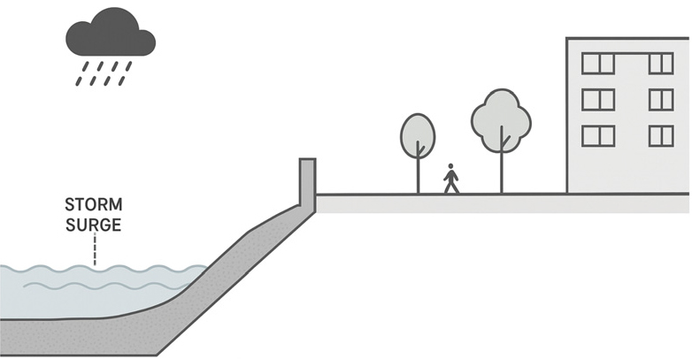
Figure 6.
Finger plan 2.0: Coastal resilience structure
Source: above figure is a conceptual cross-sectional diagram of Copenhagen’s coastal resilience structure, synthesized based on the principles outlined in the Finger Plan 2020 (Danish Ministry of Environment), the Copenhagen Cloudburst Management Plan (City of Copenhagen, 2014)
Accordingly, Copenhagen’s Finger Plan 2.0 can be understood as an evolution from a mere containment strategy against urban sprawl into a model of Resilient Coastal Urbanism capable of responding to the climate crisis. By adding a coastal development axis, so-called the Blue Finger, to the existing transportation-based fingers, the city has formulated a new paradigm of urban growth that integrates disaster mitigation, housing, commerce, and ecological restoration.
Nordhavn can be simply described as having achieved 'Transit-Oriented Eco-Urbanism and 21st-Century New Urbanism'. The project fulfilled the core principles, “Development should be transit-oriented, environmentally sustainable, and reinforce a sense of community through design” of New Urbanism. In particular, it is judged to have successfully implemented core themes, “TOD, ecological resilience, compact urban form, integration of living and working environments”. Looking at Spatial and Functional Characteristics, located on a redeveloped harbor peninsula (north of the city center), Nordhavn is designed under the Finger Plan 2.0 framework, positioning it as a rail- based urban corridor node. Incorporates metro (M4 line) as its central spine, with development structured within 400–800 m walkable catchments. Urban blocks are mixed-use and mid-rise (6–8 stories), designed to support active ground floors and internal courtyards. Principles of eco-design are also being implemented, such as district heating, stormwater retention canals, and adaptive flood- defense landscaping (coastal resilience parks). Compared to the principles of New Urbanism, it is believed that TOD, as institutionalized New Urbanism, has been partially implemented. Nordhavn operationalizes New Urbanism’s transit-first principle, prioritizing pedestrian and cycling infrastructure, with car-ownership rates capped below 25%. Environmental integration has been achieved in this region as well, where the “blue-green infrastructure” reflects New Urbanism’s ecological branch (Calthorpe, 1993; Duany et al., 2010), thereby fusing resilience and urban form. Looking at quantitative indicators, the modal share ratio consists of 49% cycling, 32% public transport, and 19% private car, according to the Danish Police open data. Public space ratio is 40% of the total land area dedicated to open and shared spaces. In other words, Nordhavn interprets New Urbanism’s principles into 21st-century Scandinavian practice, merging transit-oriented development, ecological resilience, and human-centered design into a unified, climate-adaptive urban prototype.
4. Discussion and Conclusion
1) Discussion
Copenhagen’s Finger Plan is one of the representative models of traditional European urban planning, characterized by its emphasis on urban density, mixed land use, and rail-based development. At the end of the 19th century, Ebenezer Howard proposed the Garden City concept, introducing principles of self-sufficiency, greenbelt protection, and railway integration. In the 1920s and 1930s, modern urban planning in Europe, exemplified by Vienna and the Bauhaus movement, advanced ideas of collective housing, high density, and public transport–oriented development.
However, the Finger Plan of Copenhagen not only inherits the values of traditional European planning but has evolved beyond a single case study to become a foundational model for contemporary urban theory and a pioneering laboratory of urban practice. It embodies the core ideals of sustainable urban development across environment, mobility, housing, and social cohesion. The plan established a spatial structure guided by rail corridors extending from the city center, implemented transit-oriented development, preserved green areas on the periphery, and promoted high-density growth. Introduced in the post–World War II era, the Finger Plan helped prevent inner-city overcrowding and suburban sprawl, later transforming into a flexible framework adaptable to new environmental challenges such as climate change.
In the 21st century, it advanced into the second generation “Finger Plan 2.0” as a modular approach to climate-responsive planning. With a city structure prioritizing cycling and walking and more than 400 km of dedicated bike lanes, approximately 62% of Copenhagen residents commute by bicycle as of 2020. The city aims to achieve carbon neutrality by 2025 and has implemented climate action through renewable energy, district heating, and energy-efficient building regulations. As a result, greenhouse gas emissions have been reduced by approximately 42% compared to 1995 levels. Mixed-use development combining residential, commercial, and public facilities is promoted citywide, with planning continuously revised at the neighborhood scale. This approach realizes the concept of the ‘15-minute city,’ enhancing residents’ quality of life and achieving balanced urban development (Gehl, 2010). Notably, evenly distributed public housing has mitigated spatial inequality, while policies for the protection and inclusion of immigrants and low-income groups have fostered multicultural urban landscapes and strengthened social integration. Institutional mechanisms for incorporating citizen input into planning processes have further reinforced participatory governance.
Copenhagen’s Finger Plan aligns with the principles of New Urbanism, Transit-Oriented Development, Mixed-Use Development, Walkability, strong local communities, and a return to safe and resilient traditional urban form (Table 5). Emerging in the United States in the 1980s, New Urbanism sought to move away from car-dependent urban structures, emphasizing walkability, land-use diversity, community-centered design, and the revitalization of public space (Calthorpe, 1993; Congress for the New Urbanism, 1996; Duany et al., 2000). It represents a practical paradigm that prioritizes community well-being, everyday convenience, and cultural landscape—rather than mere physical growth. It also serves as a critical example illustrating the continuity between traditional planning values and contemporary urban theory.
표 5.
The connection between New Urbanism and the Finger Plan
Source: Congress for the New Urbanism, 1996, The Charter of the New Urbanism.; Calthorpe, 1993, The Next American Metropolis: Ecology, Community, and the American Dream, Princeton Architectural Press, New York; Duany et al., 2000, Suburban Nation: The Rise of Sprawl and the Decline of the American Dream, North Point Press, New York.
As a representative model of European urbanism, the Finger Plan offers significant implications for alleviating congestion in the Seoul metropolitan region and for shaping a more decentralized, growth axis-based spatial strategy. In Korea’s metropolitan planning framework, a clearer mechanism for central–local governmental collaboration must be established. Despite having a well-developed public transit system capable of supporting multiple growth corridors, spatial development remains heavily concentrated in the Seoul core, a legacy of long-standing institutional and socio-economic dependence on the capital. Rather than further expansion of the Seoul metropolitan area, policy efforts should prioritize strengthening the distinctiveness and implementation capacity of each growth corridor. Urban growth boundary policies must be reconsidered, and stronger legislative instruments are required to institutionalize their enforcement.
National-level planning should secure ‘flexibility in planning’ to adequately reflect regional characteristics. At the same time, institutional reforms must enable autonomous models in which local governments are granted both fiscal support and legal authority. From the initial planning stages, mechanisms for citizen participation must be embedded, with professional mediation playing a critical role in balancing interests. Regional plans should not be designed to emulate Seoul but rather to preserve and enhance local identity, transforming it into a driver of regional competitiveness. In this process, geographical insight is essential for integrating historical and cultural attributes into planning modules that genuinely improve residents’ quality of life. Compact, mixed-use development strategies should be employed to ensure more efficient use of urban space, a principle aligned with the spatial density-population concentration correlations often discussed in urban geography. Additionally, explicit consideration must be given to the distribution of public and social housing. Social integration and improved accessibility for low-income groups are crucial conditions for ensuring that regional planning principles can be sustained over the long term.
2) Conclusion
The Finger Plan was devised in the aftermath of World War II as an urban planning model to alleviate congestion caused by the overconcentration of population and functions in central Copenhagen. By developing growth corridors along railway lines, the city established multiple sub-centers that reflected distinct geographical conditions and local identities, thereby dispersing urban expansion away from the core. Even during the subsequent decline of traditional industries, the principles of the Finger Plan continued to be applied in adaptive ways, allowing each axis to evolve based on its historical and cultural context. The spaces between these ‘fingers’ were strictly preserved as green belts, serving as powerful regulatory buffers, while community-oriented local planning laid the foundation for long-term regional resilience.
In the 21st century, technological change, shifting geopolitical conditions, and environmental pressures prompted the evolution of the model into what is now referred to as “Finger Plan 2.0.” Whereas the original plan focused primarily on transportation-led growth, the updated version has revised its priorities to emphasize climate change adaptation. Nevertheless, its core principles, green space preservation, transit-oriented accessibility, community strengthening through publicness, and social integration via mixed land use have been consistently maintained. Moreover, territories not included in the original framework were designated as a ‘sixth finger,’ expanding the strategy into previously excluded coastal areas. The systematized nature of the plan now allows specific initiatives to ‘flow’ flexibly in response to changing conditions while remaining grounded in an underlying spatial logic.
Since the 1980s, the paradigm of New Urbanism has emerged as a response to mounting environmental challenges, economic instability, and spatial inequalities associated with urban sprawl. New Urbanism advocates for mixed-use land development, compact and walkable communities, the preservation of historical and cultural identities, resilient spatial structures capable of responding to climate change, public transit-oriented accessibility, the activation of public spaces and social connectivity, and ecologically grounded sustainability. It is essentially an attempt to counteract the climate crises and spatial fragmentation produced by growth-oriented industrial urbanization by re-centering traditional community values. In both philosophy and practice, this approach strongly parallels the implementation logic of the Finger Plan. Ultimately, planning must be realized through the lives of residents. Its goal is to make people happy, enable them to stay in their communities, and foster an enduring sense of belonging.
Copenhagen’s once-declining industrial port of Nyhavn transformed into a vibrant cultural waterfront through the revalorization of historical heritage. Nørrebro, formerly a marginalized working-class immigrant district marked by small-scale manufacturing and deprivation, was nearly abandoned before becoming a key growth axis. Through proactive public policy and multicultural inclusion, it was reimagined as a distinctive urban landscape with strong community cohesion. Nordhavn, which lay outside the scope of the original plan, emerged as a “Blue Axis” in response to contemporary demands—becoming both a testing ground for climate adaptation and a platform for new industries, positioning itself as an international hub connected to neighboring countries such as Sweden. Strong regulation combined with flexible adaptation, public-led community empowerment, and resilience-based territorial competitiveness together embody the practical realization of sustainability.
The evolution of Copenhagen’s Finger Plan 2.0 reflects a profound synthesis between mid-20th-century spatial planning rationality and late-20th-century New Urbanist ideals of human-scale, mixed-use, and transit-oriented urbanism. While the original 1947 Finger Plan established a metropolitan framework grounded in functional zoning and rail-based growth control, its contemporary reinterpretation has re-centered the human experience within that structure. The incorporation of walkability, mixed land use, public life, and community-based design within new development areas such as Ørestad and Nordhavn demonstrates how the plan has evolved from a technocratic growth model into a socially and ecologically responsive urban vision.
Finger Plan 2.0 thus translates the New Urbanist principles of compact form, diverse neighborhoods, and transit-oriented development into a distinctly integrating climate adaptation, social equity, and participatory governance as essential design logics. Rather than importing New Urbanism as an external model, Copenhagen’s planning tradition has internalized its values through decades of iterative practice, transforming the city into a living laboratory of sustainable urbanism. In this sense, the contemporary Finger Plan exemplifies the convergence of European planning rationalism and New Urbanist humanism, where mobility, density, and livability are no longer competing paradigms but mutually reinforcing components of an adaptive urban future.
